Good Thursday, everyone. The dog days of summer are pretty much over and, for the third straight year, they gave us barely a whimper of heat. The weather pattern this month has had a pronounced fall look to it and there is no sign of that letting up over the next week, at least.
A strong cold front blasts across the region early today with showers and thunderstorms ending from west to east. Winds will be very gusty with highs only in the 70s. Skies will become partly sunny with very nice late day conditions taking shape.

This is one heck of a deep trough digging into our region today…
 Lows by Friday morning should be in the mid and upper 50s for many areas with some fog. Afternoon temps will approach 80, but the latest guidance continues to come in a little cooler…
 Either way, it looks absolutely gorgeous as we kick off the high school football season. Game time temps will be around 75 with upper 60s showing up in the 2nd half. Sweatshirt weather already?
Saturday looks equally as nice with a mix of sun and clouds. Lows will be in the 50s with afternoon highs in the upper 70s and lower 80s. There is a small threat for a shower or thunderstorm in the west.
Another fall cold front marches in here late Sunday and Monday with a scattered shower or thunderstorm. That’s another potent trough digging into the region…
 Temps behind that will be much cooler than normal for much of the week…
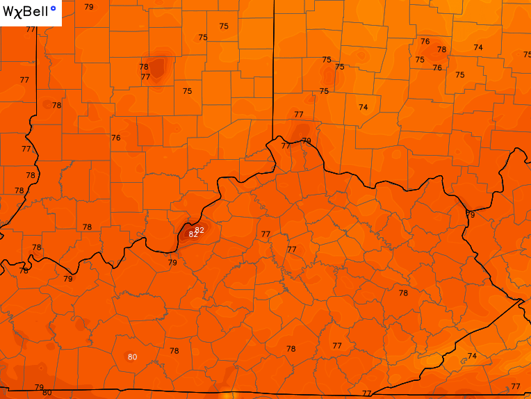
Lows in the 50s with highs ranging from the upper 70s to low 80s. How ’bout them dog days?
Have a great day and take care.

With all the talk of storms and downpours, the rain gauge on my deck in south Lex records 1/4 inch Tue thru 7:00 am this morning. Certainly seemed to be the hit or miss variety with emphasis on miss here in south Lex.
.30 here in Harlan for the entire week! We are definitely not having a wet August down here like we did in July, but we are not dry either! Actually, I have recorded about 2.5 inches for the month-to-date, so we are near normal this month.