Good Wednesday, folks. Our fall weather pattern keeps on delivering the goods across the commonwealth of Kentucky. The nice temps are also bringing a lot of dry weather, and that’s more than okay after the soggy summer we’re coming out of.
This is also the time of year we start to watch the tropics to see what’s cooking. We have Tropical Storm Erika out in the atlantic and the models are having a tough time, as usual, figuring out what to do with it.
The latest track from the Tropical Prediction Center takes this storm toward the Bahamas and strengthens it into a hurricane…

If the storms stays on the southern edge of the forecast cone, it could have a tough go at it because of the interaction with land/mountains. A lot of the straight tropical forecasting models take Erika on a track similar to what the TPC shows.
Some of the latest “regular” computer model runs try to take a weakened system into the Gulf of Mexico late this weekend or early next week. The Canadian Model, which loves to ramp up tropical systems, has the most ominous look…
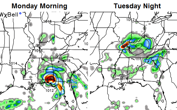 As you can see, that run brings what’s left of the system into the bluegrass state.
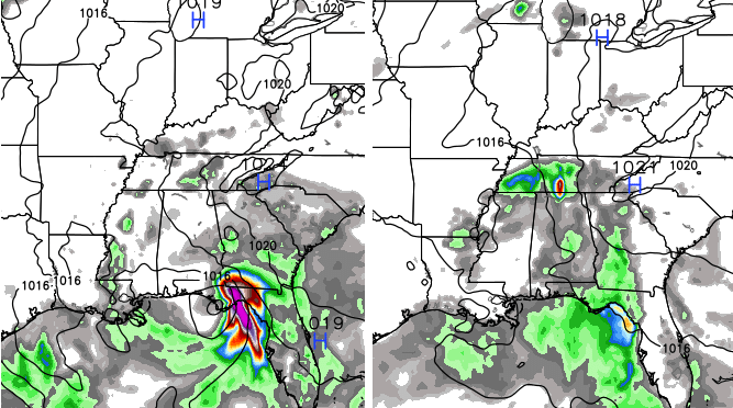
The European Model also has this in the eastern Gulf, but isn’t as strong…
 Overall, the pattern has a warmer look to it as we close in on Labor Day weekend and through much of September. Let’s see if that look actually becomes reality.
Have a great day and take care.

Going into September, one should expect tropical activity near the gulf. Over the years and especially during 2005 through 2006, we had many storms travel through or near Kentucky, so I would not be too surprised to see one this year. It is probably a good thing we have dried out nicely now just in case we get hit with several inches of rain before the tropical season is over. I remember recording over 4 inches of rain in Harlan after the remnants of Tropical rainstorm Lee came through not too many years ago!
Over this past weekend, the NWS showed it turning and going out to see. It will be interesting to see what it does now that it’s not going to cross a large amount of water. It also has too fight against the strong high that is sitting across us and the eastern part of the country.
I am glad that heat and humidity will return soon. Turns out this cool weather is a bit much for me and temps are a bit lower than was predicted (72/53 yesterday at CVG).
so now we’re back to a warmer Sept. which follows the previous backing off the warmth and going cooler the other day and the earlier warmth model before that. stay tuned fearless readers for tomorrow’s episode of As the Models Turn! 😉
p.s. everyone remember to send your next batches of heat and humidity to Covington for Shawon.
I didn’t care much for this comment. Where’s the snark to the hordes who cheer for cooler weather???
WDJB 7 Alison Parker and Adam Ward may you find more peace now than you knew in life.
CB if you see a legit donation link please throw it up on your Twitter feed. thanks.
73 and sunny here in Williamsburg….Great
I still looked at a lot of typhoon satellite loops in the southern Hemisphere and they were spinning in the same direction as hurricanes in the northern hemisphere, although I did fine ONE that was spinning clockwise..It’s interesting that all of them do not spin clockwise in the southern Hemisphere. I thought all of them did.
http://www.youtube.com/watch?v=CN05OCUpXcI
Keep us updated on tropical system Chris . I leave out to go to Texas Sunday morning. Will be going to atlanta, then westward towards Ala am a , Louisiana and Texas . Riding greyhound, that’s the route they take from london.