Good evening, gang. Heavy rain continues to fall across much of the region. Several spots have already picked up more than 1″-2″ of rain with more on the way in the coming days. That’s especially true if the big east coast storm gets cranking by the end of the week into the weekend.
The storm in itself looks like a given. The big question is, will it be able to capture Tropical Storm Joaquin? The latest GFS shows a monster storm that does just that. Notice how the model develops rain around here early Friday with possible Hurricane Joaquin lurking near the Bamamas…

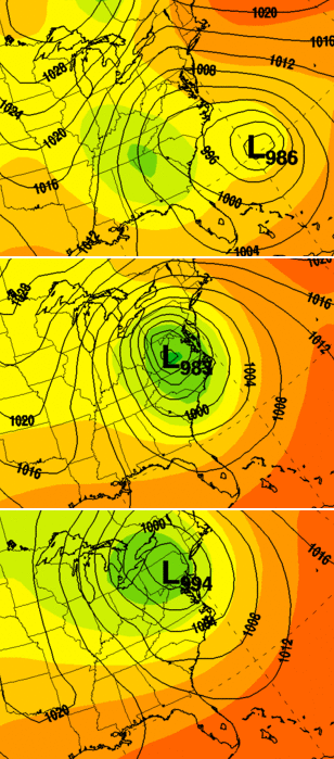
Now, watch what happens when the mid atlantic low fully captures the storm…

Notice how that monster of a storm works toward the west and northwest with rain and wind increasing around here . VERY chilly temps show up during this time…
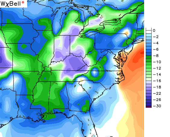
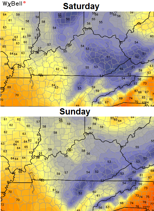 Those highs are more than 15 degrees below normal…
 The latest European Model brings similar conditions to our region, but looks a little kooky with the latest run.
The UKMET is very similar to the GFS as it shows the storm capturing Joaquin in the mid atlantic states. These are 24 increments…
 We will see how things look as we roll forward, but the potential for a very ugly weekend is there.
I leave you with your radars to track…


I’ll see you tonight for a normal update. Take care.

This unstable weather pattern will be the death of me!
Ummmm…… Why?
Exciting to me; only stressful when the weather systems fall apart and miss the area…especially winter storms! I hate when the forecast calls for a foot of snow 72 hours out then you only receive an inch or two three days later!
I’ve always noticed the season CB uses the UKMET the most is during the fall months. Little do I hear him use the UKMET in the winter and almost never in the spring and summer. Anyways, we have a very interesting weekend with a possible phasing of two systems and the tracks and template and wind. Hopefully craziness doesn’t turn to chaos for the NE US or mid- Atlantic states. 12″+ looks likely somewhere along the east coast this weekend. If any direct hit from Joaquin, expect more rain and high winds for the east while we chill with highs in the 50th and potentially 40s for some! This is why I love fall!
Not template, it’s “rain.” I have no idea how autocorrect got “template” from rain.. Oh, and I love fall for the activeness, not the destruction of a hurricane.
Not to downplay significant weather event unfolding along App Mt chain, snowing heavily in Fairbanks AK with power outages and falling trees from the heavy wet accumulation …biggest snowfall of the young season, just days after some 6″ fell.
if this was 2 months from NOW!!!WOW
Thank you CB! I’m leaving Friday fit the beach!
Oh baloney….I m tired of this all cold all the time crap…..temps will hit 70 s this weekend not 50 s!! Every outlier model doesnt mean reality.