Good Wednesday, everyone. Rains over the past few days have been nothing short of impressive. Many spots picked up well over 1″ of rain with several areas checking in with 2″-3″. As we track additional showers today, we have to really start focusing on an extreme event across the east coast. It’s one that could very well impact our weather this weekend.
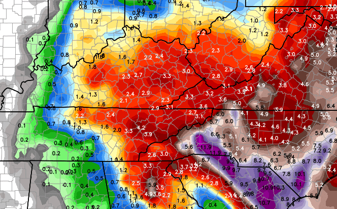
My initial thought was for some leftover showers to be noted across our region today, but a couple new computer models caught my attention. The NAM and Hi Res NAM both develop a very slow-moving area of showers across central and eastern Kentucky today. Both models keep this going into Thursday with additional action developing on Friday.
Because of the slow movement, the NAM is spitting out a ton of rain during this time…
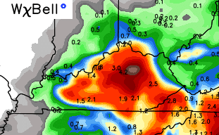
That is likely to be overdone, but it’s something I can’t dismiss given how that model nailed the two and three inch rain amounts on Tuesday. If those numbers are realized, high water concerns would come into play. We will just have to watch the radar today to see how that plays out.
Winds will be gusty today as cooler air moves in from the northwest. Temps should mainly be in the 60s and continue to drop over the next few days.
Whatever happens with the rain today and Thursday, a surge of moisture should cause rain to increase again on Friday. This time it comes back at us from the east and southeast and is ahead of the east coast monster.
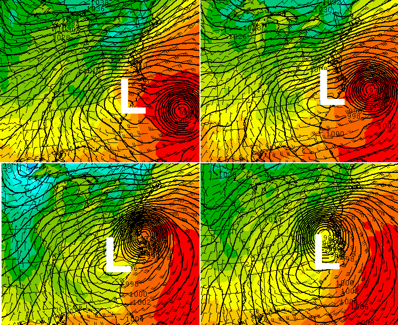
Low pressure will develop across the Mid-Atlantic states Friday. At the same time, Joaquin will be strengthening near the Bahamas. This is likely to grow into a strong hurricane before all is said and done and that’s where things really get wild.
The models continue to suggest a scenario to which the Mid-Atlantic low captures Joaquin and whips it westward into North Carolina and Virginia…
That is absolutely stunning to see and would be an absolute disaster from the Appalachian Mountains to the coast and then into the northeast.
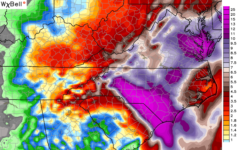
That would also likely bring gusty winds and chilly rains into our region…
That is from Friday night through Sunday night. Leftover showers and gusty winds would last into Monday on that particular run of the GFS.
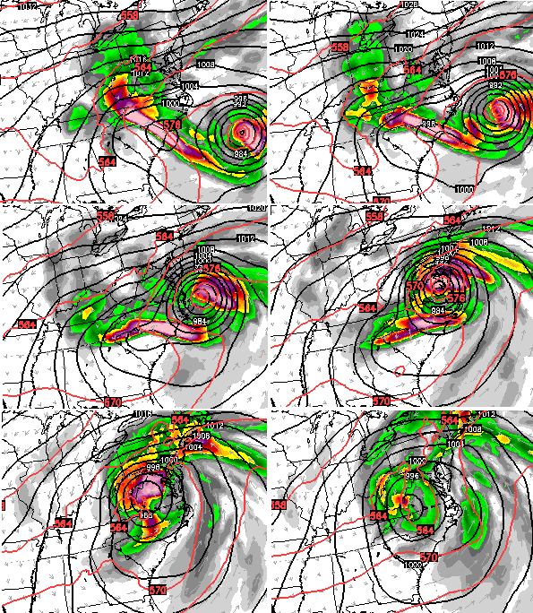
Hefty rain totals show up across eastern Kentucky, but pale in comparison to those on the other side of the mountains…
The European Model does not get the low and hurricane to hook up. That doesn’t keep the model from giving us a washout of a weekend with heavy rains…
Let me be clear, the above solutions are just a few of many possibilities to take into consideration in the coming days. With such an extreme setup, it will take some time to sort out how all that plays out.
Regardless of what happens with that storm, the weather around here will be very chilly and windy through the weekend. Showers are a good bet during this time, but the extent of the rain will be determined by what goes on to our east.
Updates as needed later today. I leave you with your daily dose of radars…


Enjoy the day and take care.

Not to sound like Chicken Little, but — a fall cold front “grabbing” a strong hurricane and pulling it into itself — isn’t that similar to Sandy?
Thanks CB 🙂 .
Besides some areas of light to moderate rain that our area has become use to as of late, this morning is also starting off with lightning strikes popping up from a line of thundershowers near Bowling Green – northeast of Nashville. Stay safe everybody!
Wow on those east coast numbers. I would hope that there is nothing like that for those people. Talk about some flooding.
Cooler weather and rain is getting me thinking of winter and snow. Hopefully we can get a few really nice ones this year on weekends only. My wife does not want to miss any school if possible. <– Good luck with that.
Thanks Chris. Hopefully this El Nino is as advertised by the folks who we taxpayers pay to predict and analyze climate (and usually do a terrible job at it) and we have at least a mini-blowtorch winter ahead of us.
In the short term, I get more concerned about the amount of rain that may fall on Saturday. It totally makes sense that the upcoming weekend – when outdoor activities are abundant – would feature the worst weather possible. We might as well get some snow flurries while we’re at it.
Take care.
Early morning GFS..Seems like heavier precip keeps getting pushed west
ttp://i.imgur.com/EnYIYyo.png
oops
http://i.imgur.com/EnYIYyo.png
Way to go, Bowling Green…over 3″ of drought-busting rain since late Monday.
Some models pulling for a hurricane vs. East coast collision, but typical heavily favored European model says out to sea you go. Irony according to meteorologists was that the European model was the only model that tracked Sandy accurately.