Good Evening, folks. High winds and heavy rain are on the way for Wednesday. That’s been covered extensively here for the past week or so. Let’s take a quick look at where we go from here.
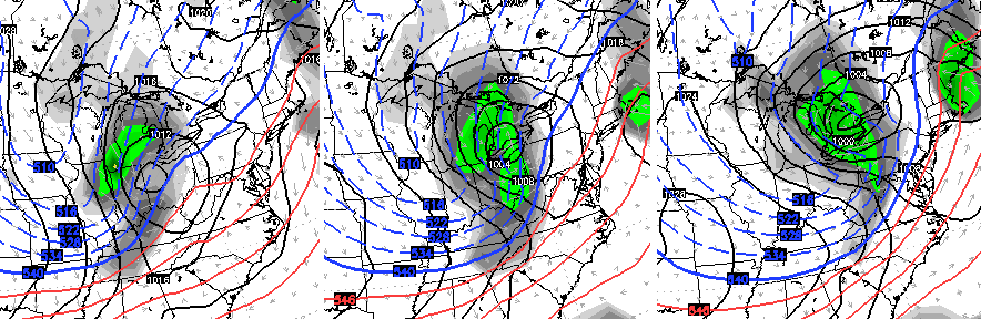
A winter looking system zips across the Ohio Valley Saturday with a band of rain and snow. The GFS and European Models are similar with this…
European
 GFS
GFS
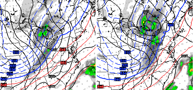 Obviously, the European model is a little more wound up with that system. The end result for us is about the same. We get a band of possible rain and snow showers working through behind a strong cold front Saturday. Winds are going to be very gusty, as well. Temps spike into the 40s ahead of the front and drop quickly behind it.
Upper teens try to sneak in here Sunday morning with highs struggling to 40.
Thanksgiving week starts chilly and dry, but a late week storm system is going to try to develop and work our way…
 Again, that’s more than a week away so we will see how the models handle this in the next several days.
A few weeks ago I was telling you about picking up on a signal for a major mid November storm system developing. That’s the one bringing a blizzard and severe weather to our west. The same one impacting us tomorrow. I’m starting to see a signal showing up as we flip the calendar to December.
Sure enough, the GFS super long range shows something…
 We shall see.
I leave you with your radars to track the action to our west…

Enjoy the evening and take care.

Thanks Chris! Looks like the Black Friday crowd will have holiday like temps next week. But wait, it’s happening this weekend as well! Oh well grab the Christmas movies and CDs. Let’s getvthis party started! Go CATS!!
Thanks CB! As you and other mets have predicted, the line closest to us is indeed weakening compared to yesterday; the severe t-storms will likely stay well to our south although as touched on a few thunder showers and heavy rains are still possible for us. Memphis is now getting t-showers and a few lightning strikes are even nearing far western Kentucky.
As we know, November is when our secondary tornado season generally peaks. It’s fortunate that many autumns are somewhat uneventful. But the autumn of 2005 was anything but……hard to believe a decade has already p-a-s-s-e-d since that turbulent November.
http://en.wikipedia.org/wiki/Mid-November_2005_tornado_outbreak
http://en.wikipedia.org/wiki/Evansville_Tornado_of_November_2005
Congrats to the word ’emoji’
Oxford’s 2015 Word of the Year
I’m still trying to figure out how Polar Vortex didn’t make the list, what was it, last year or 2013?
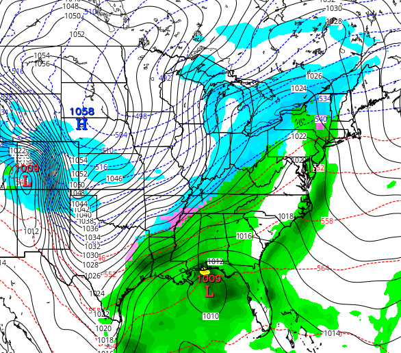
If this 1058mb high pressure should verify, that would set records again for some of the same areas that saw their highest readings ever back in January, like Lincoln and Omaha Nebraska and Topeka Kansas.