Good Saturday, everyone. A strong cold front is set to blast the bluegrass state today and that means a wild temperature ride is on the way. As temps take a big tumble, the first snowflakes of the season will be possible in many areas.
Early today, a mix of sun and clouds will help boost temps into the 50s for much of central and eastern Kentucky. A 60 is possible with enough sun. As that’s happening, temps across western Kentucky are tanking into the upper 30s and low 40s. That big temp drop works to the east behind our cold front.
A band of rain and snow showers will be along and behind the front. Some flakes may start to fly as surface temps reach the upper 30s. That zips quickly through the region into the evening with some leftover flurries late tonight and Sunday morning in the east. If you’re expecting this to be more than just the first flakes, you’re going to be disappointed.
Temperatures drop into the upper 20s and low 30s late this evening and drop into the 20-25 degree range by Sunday morning. Wind chills may hit the teens at times.
Track it all…


Sunday will see highs only in the 30s with a mix of sun and clouds. This takes us into the start of Thanksgiving week and things look to start out very nice. That changes later Thanksgiving into the long holiday weekend as a storm system moves in here.
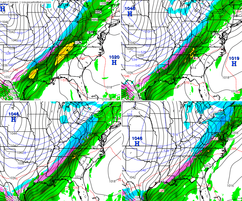
I’ve pointed out this possibility for several days and I see absolutely no reason to change it. The computer model forecasts continue to back around to this potential. The GFS continues to show a rain and a winter weather threat around here…
I will have another update later today. Buckle up for the temp ride and take care.

A local weather man said last night that Black Friday would be dry and warm with temps near 65 degrees. I wonder what model he uses.
The wishful thinking one….
Thanks Chris. It’s beginning to feel a lot like Christmas with those temps and a chance of flakes! Guess it’s about time though since we are about to get into the final week of November. The college my son in law coaches for travelled to Iowa for a playoff game and found themselves in the middle of the snowstorm part of this system. Pictures were pretty. Gotta say it GO LWC Blue Raiders! And GO CATS!!! Have a great Saturday everyone.
I love seeing more blue and pink on the map so much closer to home than just a few weeks ago! That has to be a good thing.
I learned a long time ago from Chris Bailey that putting snow on the ground to the north of us will be key to allowing cold air to build further south later.
Here’s to hoping that cold air and precip meet up to allow for some snow on the ground around here as we say goodbye to November!
The GFS simply can`t decide rain or snow for next week. All the 6z run of the GFS had was pretty much rain. Probably by the 12z or 18z run it will show us getting a blizzard! 🙂
Rodger is seeing that the Paducah NWS apparently isn’t watching the GFS. They’re calling for all rain late in the week followed by cold – just like today/tonight. Rodger wants some snow!
Nws jackson cslling for around 60 degrees late week also.
Winter 2015-16: “The Coinflip Winter”
CB, when will the models start converging on a solution for Thanksgiving weekend?
The storm chaser map causes the rest of the page to run so slow that it is silly…
Its gotten colder in this far western part of ky. But no moisture left to see our first flake. Oh well maybe next weekend.
Maybe the one person or two who live on Black Mt. in the far eastern part of Harlan Co. will see a few flakes. That is the mesonet that everybody wants to use to say that Harlan gets more snow and is colder than every other location in the state, but we (I included) never get to see most of the snow/cold listed for Harlan except for looking up high on the mountain tops. I hope we do get a pattern change soon and start to see some of the snow that Chicago and other northern cities are getting today!
Yea, places like Des Moines and Chi-town indeed got good dumpings.
But Indianapolis observed light snow at KIND for only a few hours earlier today and even that has ended.
Here in Nashville TN, the front has definitely gone through as the temp has fallen from 66 to the current 46 amid very gusty conditions.
As posted in a FB group for female meteorologists.
http://imgur.com/AlGloKs
CB, what’s the male met version of that dress?
Maybe a universal ugly tie?
Having trouble posting so no update this evening. Tonight might even be a struggle by the looks of things. Ugh!
Thanks Chris for telling us. Hope you get it to work.
Don’t sweat it Chris. Just make it up to us with an extra long post sometime tomorrow that screams SNOW! 🙂
Rain/Snow showers just went through the east side of Louisville it was short and sweet but nonetheless the first snowflakes of the season.
Its extremely windy up.here on the ridge in greenup…temp is 40 degrees
Just seen the first snowflakes of the winter here on the ridge in greenup
No flakes in Bowling Green today yet, and the radar certainly doesn’t look promising. 🙁
NWS says 60’s Thanksgiving, Friday the 27th and 50’s for the 28th…..sounds good for shopping according to the Mrs. lol
They’re wrong
I believe you Chris! Rock on!
Just now able to get onto your site. Alert kept saying all night that your sight was hacked and server could not be found. Warned of being sent to malware?? What ever that is! Not tech smart. Know just the basics. Glad to finally get you back!