Good Tuesday and welcome to the month of December. The first day of meteorological winter is off and running with… Rain! That doesn’t exactly qualify as breaking news considering how wet things have been of late. What about the chance for some of the white stuff? I do have a small chance for some flakes before the week is over.
Let’s start with today and the heavy rain sweeping across central and eastern Kentucky. Hmm… what else can I say about it? Nothing, so track it…

Rain will slowly taper from west to east late this afternoon into the evening, but the drops may hang around into Wednesday morning across the east.
Temps drop quickly behind the front sweeping through here, but the cold is really nothing to write home about. It’s a seasonal chilly that may combine with a northwesterly flow to produce some rain or snow showers Wednesday night…
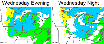
 That could put down some accumulations as close by as the West Virginia mountains, but I don’t expect anything at all around our part of the world. A few flakes might be as good as it gets.
Much better weather moves in for later in the week into the weekend.
After that, we have to watch for another system to arrive late weekend or early next week. The overall setup for the middle of December continues to show signs of changing. The Ensembles have been hinting at this for a while and the operational models are trying to do the same. The latest GFS is the latest example…


As always, we shall see.
Another update comes your way later today. Take care.

2″ or more of snow on Christmas Eve. This.Must.Happen. Muwahaha.
It will be interesting to see going forward how the ridiculously wet (and therefore warm) ground will delay and/or inhibit any snows we do get in the short to mid term.
Rodger somewhat depressed about this warmth and rain. However, he knows the best chances of measurable snow are almost always late Jan/Feb in the lower Ohio Valley. Keep the faith, snowmen!
Redneck Bunker seeing a Christmas week storm, even possible for a WHITE Christmas!!!! long way out though so we will see.
Pattern isn’t against this happening! 🙂
Very seldom we get significant snow in December. Just gotta be patient untill Jan, Feb, March.