Good Wednesday to one and all. The waves of heavy rain we’ve had for the past 5 days are finally pulling out of the bluegrass state. This action left behind a general 2″-4″ of rain in many areas… Something that had been on our radar some 10 days before it happened.
Now, we focus on the potential for a few snowflakes dancing about the December air later this evening into tonight. The best chance for this happening is across the central and eastern parts of the state…
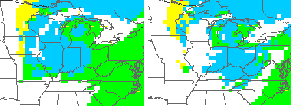 If we are to get a rooftop duster, our northern counties appear to be the areas to watch.
All that quickly moves away with better weather rolling in for the end of the week and into the weekend. Enjoy that because odds favor another upper level low impacting the region by Monday and Tuesday…
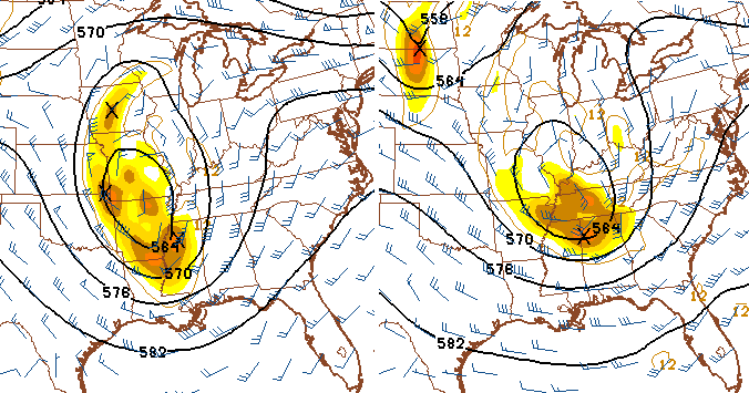
We will have to watch that setup as we get closer. Something bigger than currently modeled may spin up out of type of look. From there, we see the pattern across much of the country take on more of a winter look.
I’m going to try to break down some of the winters I think are similar to this one… If I can find the time to get it all done and written up. 🙂
Here’s your daily dose of weather tracking toys to keep you company until we meet again later today…

Make it a fantabulous day and take care.

I woke up this morning to a total of 2.84 inches since mid-day yesterday (most fell during last night). My running total here at the house since Sunday is now 5.10 inches of rain. WOW! You gotta love KY weather: From near drought to near flood in a couple of days.
Chris, what do you think the chances of us having a white Christmas this year?
Wow! Rodger has seen much more activity/comments on this board in years past by now. Here’s hoping Mr Bailey can scare up some wintery mischief in the next ten days-two weeks!
Thanks Chris. Always enjoy reading your updates. The mention of a few flakes once again has ones fancy turning to a nice big snow at some point this winter. Let me clarify this for those of you who are ready to clobber me…I only ask for ONE good snow per winter. I can take the ankle biters if we can get that one big beautiful one. In any event that looks to be a while away yet.
Hope everyone is having a great Wednesday! Hope the rest of it is as good! Thanks again Chris, for all you do!
Looks like it may me getting a little warm in the coming days..Furnace warm..Maybe a few records will go down..If we Furnace may as well be a big Furnace..