Good Tuesday afternoon, folks. Our band of snow continues to quickly push across the state as arctic air pours in. The most snow appears to have fallen along and just north of the Interstate 64 corridor. Roads in these areas have been snow covered at times.
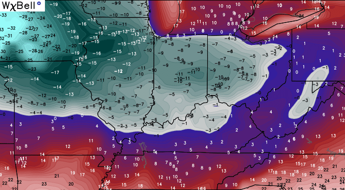
Temps will drop like a rock from west to east this afternoon and wind up in the teens this evening. Some single digits will show up by Wednesday morning.
A weaker clipper works just to our north Wednesday night and may get close enough to throw a few flakes into Kentucky. The simulated radar from the NAM…

As that passes by, temps will briefly moderate Thursday into Friday. That’s when another storm system works our way. Rains will increase late Thursday into Friday as low pressure approaches. As this low works through here, temps take a big tumble Friday night and Saturday with rain changing to snow as wraparound moisture hangs tough…
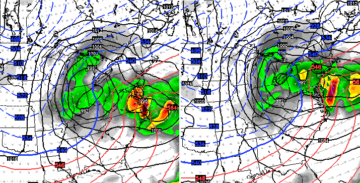
Snow showers would then continue later Saturday into Saturday night with light accumulations possible.
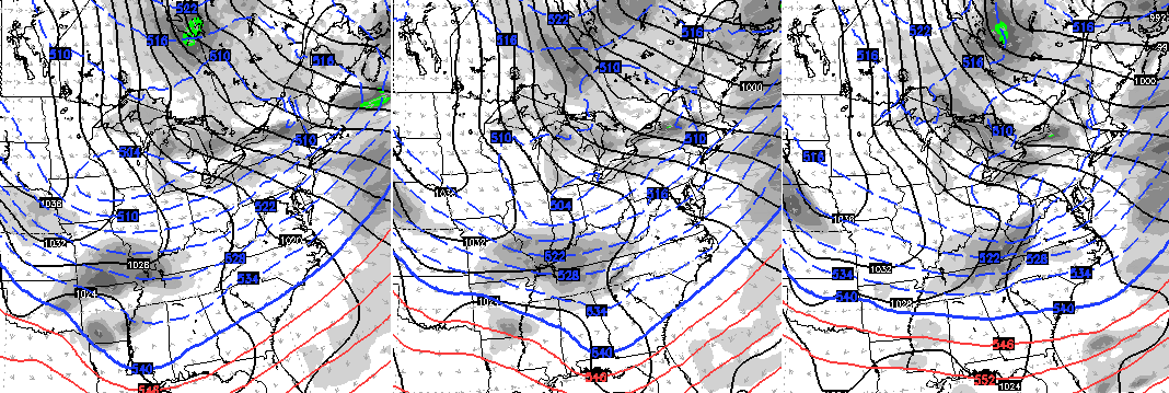
Arctic air then surges in here later Sunday and should include a band of snow. Here’s the Canadian Model…
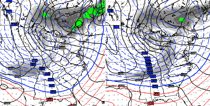
Temps by Monday morning on the same mode run…
The GFS takes a different approach in getting the arctic air in here. The latest run takes a system across the deep south then brushes the region with some light snow on Sunday…
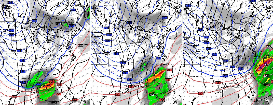
The arctic system then arrives with a band of snow on Monday…
I will have another update this evening. Your tracking toys to carry you through the day…

Take care.

HEAVY snow squall here in SE Lexington!
Congrats to anyone who got some snow that was hoping for it! In Monticello we’ve had a quick moving burst of flakes but it left nothing behind. For the weekend system would it be safe to say the gfs solution seems to be the more sound one at this point?
Looks like Fayette Co schools made the right call. Quite a bit of snow fell, but after school started and looks like it will be gone by the time school lets out.
Snowed pretty hard for a while and actually covered stuff for a bit. Overall, it snowed a good 1.5-2 hours and covered things up a bit. But the temps. where warm enough that it melted off already. 35 right now. A break in the clouds for a few minutes but they are back. My wife was really hoping that there would not be a snow day but they cancelled anyway. She really does not want to have any make-up days and just get out on schedule or as close to it.
Sun came out for a little bit and then just now huge wind bursts in Berea with blowing snow. It’s not on radar but it’s here and we’ll take it! We might get a coating after all!
Morehead got a real burst of 3-4 with NO treatment or attention to roads. 1 minor one major accident seen coming out of town and I-64 moving at 40 mph to Carter Co Line Where Carter Had taken care of its roads! So the weather is only as good as those seeing to the roads!
What happend to my 1 to 2 inches of snow? Didn’t get anything in Floyd co
be careful, you’ll touch a nerve with some. my opinion, epic fail
And used a snow day for nothing
It’s called a “bust.”
Here in Floyd Co., we built a snowman this morning.
Sunshine here in Knox Co. School was called off in the county, but I think they would of been okay to go. Have to go with the forecast and play it safe I guess. Just puts you in a spot where when you really need off you may look back on it and think about not going on the day that you could and don’t take the next day that you should.
I heard there was a lot of ice up Stinking Creek
About one and a half to two hours of snow in Huntington. Briefly dusted ground and trees, beautiful for about 30 minutes. Then sun appears and now you wouldn’t know it snowed if you hadn’t seen it. This was better than the last couple clippers but still very weak. I guess in a Winter like this, beggars can’t be choosers.
Stretches of I-70, I-65 and I-74 in Indiana were shutdown due to multi-vehicle wrecks this morning. Only a couple of inches of snow involved, but it was white-out conditions at times.
So most of us may have escaped the worst of this mess.
no snow in Pikeville. however its been very windy though. seen a few flurries today and that is about it. all in all, we might have had less than 10 minutes of flurries. been partly sunny here today and temps hovering around 39-41 degrees most of the day. at the time of this typing, 301pm, its 40.2 on my front porch.
So far, all the snow events have been less than expected and the out looks are weaker for snow chances as we get closer to the time of the events. Just like old times! 🙂 We got spoiled by them there mega snows last winter anyway 😉
As mentioned before, the best of luck to CB forecasting snow this winter. Key word seems “dynamic” this winter.
Second band of snow did a great job. Almost an inch and that is not considering the melting that was taking place. Took my son out in it after it let up. Sadly, it all melted already. Still sitting at 35. Figured the temps. would have dropped off some by now. Seems some places are not confident in their low forecasts either for my area. Have seen them raise the overnight temp. outlook a few degrees already.
I will say it was a beautiful snow though. Big flakes. And a lot of them. Was building up quick.
We are looking at being in mid-January and not even a dusting for most places. I’m okay with that as long as we have warm days when its supposed to be here. I live in one of the few areas in KY that missed out on the significant snow last year, and while I like the stuff, if we are not going to get over an inch I would just as soon to see warmer air.
I cant believe ive followed this blog on and off for 5 years now and so many let downs and disapointments i really fell for it again this time and thought laurel county school was being foolish by not calling off school.now i feel like the fool once more for nelieving the hype.
Festive flakes here was all we got and temps are still in the 40s but it is very windy
I would rather have a reliable forcast without the hype and dreams of snow so i will no longer be following.
Don’t let the front door hit ya where the good Lord split ya!
Chris Bailey does have a reliable forecast. He doesn`t hype snow events. Kentucky is in a great location, expescially within the last several years hasn`t been in what one would call the sweet spot for snow. CB doesn`t control the weather he takes the information that he has received from the different tools he has to his despense, and uses them. CB, in my opinion, is one of the best mets in Kentucky. He is just doing his job. I`m sorry you feel that way.
He is definitely one of the best. I have seen forecasts calling for snow and Bailey will be showing models and then saying he does not buy it. And then the snow does not pan out. From this alone it is obvious that those places are using a certain model for the majority of their forecast and the next day forecast can change a decent bit all through the day.
I have seen calls for warmer than average and no snow. Bailey calling for colder temps. and snow for some here and there. And again, he is correct.
Just a lot of instances like that. Sure, he is not going to hit them all perfectly. And he cannot control that one place gets 2-3 inches while another gets nothing in his forecast coverage areas.
Today, I saw a bunch of snow. Twice we got a good coverage event but temps. did not play nice and when the snow stopped it melted. Twice. Road, however, is very slick. Main roads not at all but from what I hear a good number of the side roads are.
I agree! Chris Bailey isn’t the weather fairy godmother, but he IS reliable and the best in the area!!
Sorry if ive offended anyone but ive bit my tounge long enough and its not the first time ive been left to feel this way after another hyped bust
I am sorry you feel like that.
when you have a clipper the majority of the time it can be compared to a August scattered storm forecast.
if you’re under the cloud you will receive a burst of precipitation the other locations in close proximity remain dry.
Chris is a snow lover, but neither a lover of hype nor ignorance. He uses all of his tools, presents many of them for us, and explains his reasons for his forecast. Anyone can go back and read his forecast for this storm be see that it was accurate–heavier bands set up in some areas while other areas received a dusting. Those in areas outside of the heavy bands naturally may feel disappointed. Many news outlets currently have snow pictures from various areas which show proof of the accuracy of the forecast. While weather forecasting has become more reliable, it’s never 100%.
Typo correction: “and see”. Oops
Headed out for some stuff for a dish I wanted to make. Whole road for about 2.5 miles solid ice. Almost hit the ditch or creek a few times. Hope the bus does not attempt tomorrow. I was using 4×4 but nothing is good on ice.
Did see a forecast for some freezing rain possibly upcoming for my area. Surely hope they are wrong on that.
Woke this morning in Richmond, drove to Williamsburg / Corbin area and back this afternoon. Never saw more than a flake. Did it snow?
My sister lives and works in Georgetown KY; she said they briefly had whiteout conditions with close to a windblown inch on the ground (including on roads, with some accidents). But when the sun came out, the snow started melting rapidly.
no 2nd band of snow for Pikeville. well, not at my house. we have had a nice partly sunny day & evening. temps still hovering around 40* at this 6pm hour. ….the wind is really starting to pick up even more. it rocks my car while stopped at a red light. i had chase down my garbage cans earlier.
Cant win em all. CB does great. The weather doesnt always listen to the computers. Maybe se ky will get one before winters end.
I figured there would be the usual brown nosers to the cb rescue.but i feel im not the only one that realized 40 degrees was to warm to be called arctic and im probably not the only one that thought temps would tumble through the day and not hang at 40 with sunshine and wind most of the day.but it sure seams im the only one that will admit it.it seams people ate scared if they say something that might offend the forcaster that they might stop forcasting and shut the blog down.it shouldnt be like that.but ive been a very faithful veiwer to the blog for at least 5 full years so dont think that i havnt put in my time waiting for the 2 am post each night then checking back midday and evening and reading through all the coments
Ive just finallu seem enouph and wanted my opinion heard before i left
Um, just leave already. Your negativity is not needed here. Stop threatening to leave and just do it.
I agree Kayla. Yes, the blog is entertaining but it’s usually so extreme towards cold it becomes laughable. He may be a fine meteorologist but he is obviously a cold/snow lover and is always looking for the one model that is different than all the others and if it shows cold and snowy he is posting it for us to see. This Sunday on Wkyt, where he is chief, was showing attic front wed, 23 for the high thurs!!! 30 for fri and 32 sat!! Thursday forecast alone was approx 30 degrees colder than any other forecaster. Bye this past Monday morning they had it 20 degrees warmer for Thursday and Friday. I’m sorry but that is bad meteorological practices. A meteorologist shouldn’t be that far off with the forecasts. He tries so hard to be different and they only one to forecast a certain event that he eats crow A LOT. I only look at his blog as pure entertainment value with no real sense of accuracy.
Chris is one of the best meteorologists in the Kentucky, Indiana area. He does a fantastic job with his daily forecasts. Keep up the great work Chris.