Good afternoon, folks. A major winter storm is going to try and shut down much of the bluegrass state Friday into Friday night. Significant snowfall and high winds will combine to produce whiteout conditions for several hours. While we may never crack blizzard criteria, for some, it’s going to be as close as you can get.
The midday models didn’t really stray too far from prior runs. Every run is going to show variance from it’s prior run… that is to be expected. As long as it’s nothing drastic, there’s no reason to get worked up over little changes here or there.
Here’s a model preview of current snowfall forecasts:
GFS
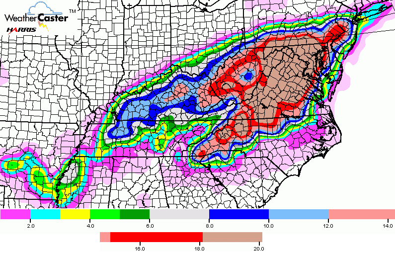
NAM
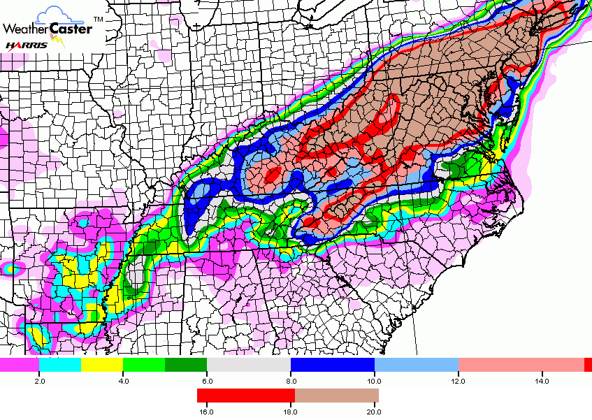
Hi-Res NAM
This model run has me spooked just a bit because of just how much moisture it’s showing. It matches what the SREF (Short Range Ensembles Forecast) has been showing for a few days now. It continues to spit out a ridiculous amount of precipitation across our region.
As such, I’ve expanded the heaviest snow area and totals by a bit…
I will continue to update that map later today and put out a final call later tonight.
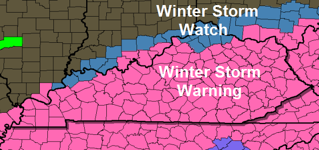
Much of Kentucky is now under a Winter Storm Warning…
In addition to the heavy snow, blowing and drifting snow will be common across our region. The absolute worst part of this storm occurs from mid morning Friday through the wee hours of Saturday morning.
I will have the latest on WKYT-TV starting at 4pm. See ya there and keep checking back for updates.
Enjoy all the bread and milk you bought and take care.

Thanks Chris! Wow! Just Wow!
Everyone is gonna get some snow!!!!
Sorry SE KY. We tried to tell you all it wasn’t shifting to your area. Nelson County still on track to get a big one.
Uhhh…..3 to 8 inches is not a miss. By the time its all over we’ll have more than you anyway.
I’m glad you can tell us for sure when the meteorologist and the models can’t..maybe they should hire you?
Lol. By my estimation, SEi KY will be the winner, as we will hopefully dig out and be back to normal long before you. As far as I’m concerned, I would rather have an all rain event
Those SEKY tears taste sooo good. I dont get how “Western” thinks he’ll have more.
Why so nasty? It’s not like this is going to permanently alter anyone’s life. Southeast Kentucky is still going to get snow, so no big deal. I really dislike some of the attitudes I’m seeing on this blog as of late…
I have to agree with you. It’s just not right to have a mean attitude. Who cares who gets what amount. Seems like according to Chris everybody will get some snow. Grow up people.
Yea I hate the attitude from these city ppl. Love there wish casting. By there attitudes I hope Louisville gets missed
Im not from Louisville. Nice try though.
What’s wrong with you??? Why do you always try to provoke everybody?
The attitudes haven’t changed there is just more of them
How old are you, 8? Gloating over snowfall? You have deep issues, go get help.
Lol.
3 comments in and people already arguing…. over snow. It’s amazing.
Oh yea! Well you’re a big dookie face!
I should have known that someone would find a way to troll a weather blog. Bravo.
I still have 4″ from yesterday still on ground. Lol
Looks like a huge storm and the entire KY/ S IN area will be hit hard. I don’t have much to say, but wanted to be one of the first to comment on this new post. Stay safe.
Just don’t Pull the football and we will all be ok….Right BubbaG
Well look at that, most of ky has a shot at a foot, even those who dont have a chance at 8, that is rare
I second “C in BG” on the WOW! And throw in a yikes!
It really seems to be coming together now. I’m excited about all the blog chatter coming.
Thanks Chris.
Maybe I should put my bread and milk on Ebay 😉
i was thinking the same thing. Bell county always seems to be on the light end of totals. lol
Oh come on NWS just put the whole state under a warning it’s only a handful of county’s left out. Has it ever happen where every county in the Commonwealth was under a WSW?
Um, I was thinking the same thing and I think it has happened a couple of times.
Winter Storm Thor last march caused every county to be under a WSW, I believe.
This one have a name?
Jonas
I would call it “Megagigantor”? (pronounced — mega – ji – gan- tour ) The more ominous the the name – the more it snows… At least that’s my opinion.
Thanks Chris. Looks like we are all in for a pretty good thumping. Better get what you need now! Later on anywhere will be a zoo. Looking firwRd to the next update. Keep those tweets coming Chris. But get some sleep!!!
Looks similar to some select locations of my call, but my confidence is much lower because the models still do not have a really good grasp on this thing, too dynamic in my opinion
Jefferson County right on the line between 2-16″ lol
I was looking at the same thing, wow
That puts us in the biggest bust potential. I do like that we are more in the 6-8 on all the above maps. Odds of this pulling North is greater the pulling to the South. Over the year trends have me liking the looks of these maps, but the bust potential is there.
Winds will be coming from the northeast so it will have a hard time making it too far north. I hope it makes to Louisville and stops right there. Southern Indiana has stolen our snow enough ha ha. Let those Hoosiers feel our pain.
On Wednesday , McCreary was forecasted for 1-3 and we received 5 and 6 in some places. I think that even if you are in an area that is forecasted for less than double digit snow – you should STILL PREPARE for a major snowstorm !!!
Hm, I hope Chris is right. 2-8 in Covington seems much too hopeful from the multiple models I’ve seen and even the ones he is showing. Either way, I’ll take it.
Good luck everyone.
His map still needs to come North.. You cannot go off the regular NAM and GFS… They are pointless now.. Gotta go Hi RES HRRR SREF rapid refresh models.
Now that the 12Z runs are in (Except for Dr. No); it is time to take my own advice, and head out to the store and get the comfort food I need until Sunday or Monday, and a little for regular meals. Take care, be safe everyone; and if you go to the store, post some pics if they are worthy.
That Hi-res NAM…I want it
High in Corbin today was forecast upper 30s….It’s only 28 where I am. Hmmmmm
It’s only 23 here in Lexington.
I agree I have noticed on my weather app temp is not supposed to get above 39 and it is 33 right now.
I am originally from Ohio, but have lived in KY since Fall 2005. This appears to be a great snow, and it kind of reminds me of the snow we had in the Dayton Ohio area in 1998. I think this may be the first time I’ve seen a forecast for snow cover nearly the entire state.
Lets hope the icing is kept to a minimum and that we enjoy the cold snow from our warm homes. I look forward to a hopeful snow day tomorrow, and adult beverages during the event! Keep safe everyone.
Chris said this may not meet blizzard criteria, but it will be the closest thing to it? Like I said on my last comment just before he updated, the Feb 98 storm was a blizzard to me. It had the exact same feel of the superstorm 93 snowstorm I was in the middle of in Western NC, just heavy snow, wind….it acts like a blizzard, feels like a blizzard, looks like a blizzard, but technically, it’s not a blizzard…….whatever…
My kids are certainly excited about it!
It’s a “blizz” 😉
It’s KY, so let’s go with “Blizz-tard”.
LouMetro on a rolo coaster ride. Up and down with about 5 inches being the average so Im going with 5. Anything else would be a bonus.
Good Call, as I said above. We are in a big bust area being on the northwest side of the storm. Just a matter of 10-20 miles separates 2-16 inches.
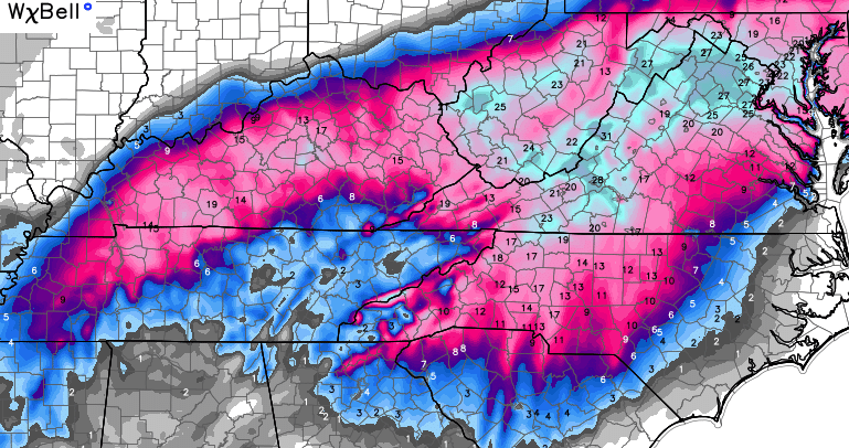
The #1 key is the placement of the deformation band and the strength. If early precip. arrives heavy, the switch to snow should be quick for southern areas and higher totals should be seen. If precip starts light, look for warmth to invade deeper into Kentucky, but should intensify shortly after. Dynamic cooling is what is causing this to be a heavy, wet snow. Snow ratios increase throughout the event. We need to start looking West as the precip shield approaches late tonight into tomorrow morning to start nowcasting.
Exactly, who can flirt with the rain, ice line, but stay all snow will get the most. Right now that looks to be somewhere around the area of Richmond, Berea, Mt Vernon, Stanford, Danville, etc..
RagSNOWrök!!!!
How long is this snow going to hang around?
For those of us that have to go to work tomorrow in Central KY (Hello, UK Hospital!), any guesses as to how difficult it will be to get home, around 5 / 5:30 tomorrow evening? Everything I’m seeing shows the real snowfall to start around 8 or 9 AM, so getting TO work shouldn’t be terrible. But I really don’t want to spend the weekend in my office…
I work in a medical facility too and have the same question you do.
Jefferson County KY look at that you might get 4 inches in the NE part of the county and possible double digits numbers in the sw and se part of the county. That’s comical reminds me of a Lake Effect event.
I know its messed up. I live in south of I264 so Im planning on 5-6 now.
We moved to the Florence, SC area from KY last spring, and I have yet to find any local weather forecaster who could predict more than drought all year. So, with any chance of nasty weather, I still come to this site as Chris is the best and most informative I’ve ever seen. Anyway, I know we won’t be getting dumped with snow, but does anyone have any idea how far the potential for ice will be in the northeast corner of SC? I ask because the locals don’t own salt trucks or snow plows and I don’t want to be on the roads with folks who don’t know how to handle a real winter.
On the bright side, I miss the snow but not the frozen water lines, frozen water buckets and cleaning stalls during such nasty winter temps. =) Having horses in this climate looks a whole lot easier!
Thanks for any guidance you can throw my way and stay warm and safe. Make a snowman for us!
On wkyt when there showing the rain snow line. It shows me being 29 with green(rain) on me. How’s that possible.
Freezing Rain…..Warmer upper layer melts the snow and if it under 32 at the ground…ICE ICE Baby.
Anybody know when the precip is supposed to start in Central KY? My WKYT weather app says not until 8am tomorrow.
pretty close, 7 or 8am is probably best bet
I thought CB said 4AM. This changed?
4 A.M. sure sounds like mid morning to me. Looks like I will need to get out early to keep on top of the plowing. Going to be a long long Friday.
that be correct Hack
Out of 120 counties only four is in the low end of the total and its the same four that the dome survived in last year. I would buy into the argument that it’s all based on location, but we had 20+ inches here back in the late 90s. Maybe the maps are wrong, but it looks as though the majority of the state has busted the dome more than a couple of times in the last two years while the same four counties miss out. Hopefully it busts this time.
So where in in London we are split 3 ways..lol! I have 3 girls hoping we are on the high side..it’s looking like we are gonna get it too here close to Harley Davidson! Everyone stay safe and warm!
friends of Chris Bailey Clay Co chapter facebook page growing by the minute!!! join us!!!! twitter handle @redneckbunker for horse plays as well Redneck Bunker handicapping facebook page I appreciate the likes as well. BAILEY gets me excited just watching him on the tube or here. I get down sometimes, but Bailey Boy cheers me up with his love of the weather!!!!
Geez, what is the criteria for a blizzard?
35 mph winds for three hours or more that reduce visibility to 1/4 mile or less. And snow of course.
Temps a bust so far today. Figured we wouldn’t have much snowpack today but still holding on to 3 inches. That may help keep temps down a degree or 2 tomorrow also
Hope you get your snow trent
Temps supposed to be at about 34 in BG; however, it is 29 at the mesonet. It makes me wonder….
Still holding just below freezing here in Bowling Green and holding on to a 2″ accumulation. Have to see what the temps do the next few hours and deep into the evening.
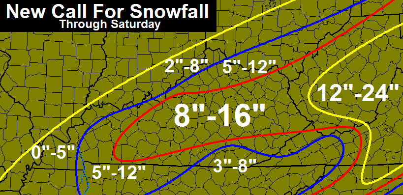
Corey Chris now has northern part of my county 8-16. Middle part 5-12. Southern part 3-8. I live in northern part so I’m in 8-16 but 3-16 in one county worrys me
Nws says 2 tenths inch of ice and around an inch of snow for the middle of Whitley County. That’s a pretty sad forecast
Yikes. Heavy big snow potential and wind followed by colder temps. I expected the high totals to shift east, but trust CB far more than my estimates.
This could trump last year’s events for most- in part due to the cold following it and especially the wind.
Absolutely….
I am a huge fan of snow and my nick name is snow queen. I am in Greenup so I am in the highest amount for snow totals. But this snow is not coming at a good time. My husband was admitted to the hospital yesterday for kidney stone and will be here until Friday or Saturday so this is going to be fun going back n forth from the house checking on my kids and the farm n then going back to the hospital.
Sorry to hear that Sue. You really are being torn between two places.
Thank you! Going to be a fun weekend!
Not sure what to believe.. Here is WSAZ’s noon forecast
Notice the totals are way north of Chris’s..
http://www.wsaz.com/content/forecast/First-Warning-Weather.html
Chris’ forecast seems to line up better than Josh’s when comparing them to the NWS predictions… so I’m going with CB.
It looked to me fairly similar to CB’s.
Josh is showing 3-6 in a LARGE portion of the 8-16 that Chris is showing.
Not sure what it’ll take for Wayne county to be on high end, second year in a row we get the short end! Hey at long as it isn’t ice, right.
Chris is there any likelyhood of us missing the ice part? Hoping for pure snow.
It’s shifting south again. Knoxville Tennessee just upgraded from a Winter Weather Advisory to a Winter Storm Warning.
Not too sure of that. It is the models and not the system shifting (the system has come together yet). Seems local NWS offices are covering themselves at this point, just in case of the track is different or the system expands.
The models have came back south. One run of the nam last night went north and everyone is going by that. The wpc said there not going by that cuz those run had trouble initializing and that reflects there forecasts
NWS out of Jackson is a Joke for snow. Always has been always will be. Lol
“Every run is going to show variance from it’s prior run… that is to be expected. As long as it’s nothing drastic, there’s no reason to get worked up over little changes here or there.”
Well, that guideline would pretty much shut down 90% of the usual blog comments obsessing about model minutia.
Nope! We are creatures of selective reading 🙂 😉
As my nephew said here in Eastern Ky everything is either up or down a hill. We are inching closer each run to 12 inches plus up Weather Channel is calling this Storm Jonas. Here we are calling it the Zombie Storm as it arrived in ‘the dead of winter’ I’ll sit tight on my hill and watch it fall!
Thanks Chris for update!!!!!!! Everyone is going to have Fun in the snow this weekend. Everyone stay warm and safe and have some fun sledding!
So essentially this will be about as much snow as we had from the last two epic snows, only those were calm heavy snows, this will be windy….so this will be worse than the last two big snows if the forecast totals happen.
If pans out- yes. Eastern states though might be on the epic scale.
Mark, You mentioned the 1993 storm…that you were not around here at the time. That storm actually shut down the state for several days…even I-64 was shut for DAYS to the east of Lexington. It was an absolute mess…catastrophe for many areas. It looks like maybe a repeat of that storm for parts of the state…but not as widespread over the entire state as the 1993 storm.
Wow! March 1993 was the biggest snow I have ever seen! I’m not good with dates, but I remember it well as I was 7 months pregnant with my firstborn and I was out waddling in it.
We have 36 inches of snow in my front yard in Pikeville when the 1993 blizzard ended…and I lived in a valley, not on a mountain top. I believe we were out of school for 3 weeks.
Sounds like we’re in for a good dusting of snow this weekend! Stay safe, everyone, and enjoy!
What is the expected timing? Last night CB said about 4AM, but seen posts saying 7AM or 8AM.
Also, notice the possible Freudian slip from CB:
“The absolute WORST part of this storm occurs from mid morning Friday through the wee hours of Saturday morning”.
This system is probably not as much snow fun to CB and potentially a serious event concern. Heavy big snow, cold and wind…. Makes sense!
I’m hoping for 3 feet of snow.
Knoxville NWS just upped their snow totals to 2 to 5 inches on top of sleet and ice. Could be a shift or a ever widening storm?
Or maybe the hi temps bust today?
I think it’s a shift south but Mets don’t want to jump the gun YET. Hopefully tonight on last call we will see real numbers. 😉
Or just colder temps? Lol
This
they were quick to jump last night lol
Channel 8 out of Knoxville broke coverage and came on air stating new model run was giving them 6″. You could tell in their voice they are now concerned.
Balloons are showing that the upper air is colder than predicted. As a result, areas like Knoxsville that were predicted to get more rain and ice are now predicted to get more snow. It has nothing to do with the storm shifting south, nor is their any indication that the models are shifting south.
This
Thanks.
like
What’s euro say just for fun
Huge bust in temps today, forecast was upper 30’s while as of 2 PM the temperature was still in the upper 20’s.
EURO – I came across an item re the Euro that someone may wish to explain better. The noon run of two days ago showed the low pressure system at noon tomorrow at 1004mb, the noon run of yday showed the low pressure at noon tomorrow at 1000mb, and today’s run shows the low pressure at noon tomorrow at 997. I interpret that to indicate a much stronger storm than euro felt two days ago. The same tendency shows up when comparing the runs for the storm once it reaches the east coast. Comments?
Seeing the first returns on Defender already along the Cumberland Parkway.
4k NAM certainly wants to shut down the state. 18+ inch band from E-town cutting straight through Lexington and into W. Virginia. Also has 6″ in northern and 15″ in southern Jefferson county alone! This could be a bust on the northern fringe or a BOOM, depending on exactly where that band sets up. Also, the good news is that today’s model runs have been coming in colder, so less likely for major ice accums. in S. KY
“Good” news depends on one’s perspective 😉
I can’t see anyone’s perspective on ice being “good,” at least I hope not. lol
Wow! That 18 inch band should get me out of work Saturday.
Map here, hopefully link works…
http://beta.wxcaster.com/loops/nam227_model_loop2.php?fcsthour=60&type=SFC_ACCUM-SNOW-10®ion=KY-TN&basehr=12Z&loop=NOLOOP
This is a new map to me. Can you explain?
It is a snowfall map, color key is on the bottom of map.
Lovely. Southern Pulaski county gets 1″. Northern Pulaski county gets 12″?!?! When you’re on the fence you’re not going to know into you look out your window what you’re going to get.
CIPS Historical Analog now shows Jan/1996 blizzard as the number 1 analog for the east coast…Still, #2 analog for our region
Sun out now though. Might warm it up a bit
…have to drive from Richmond to Bowling Green Friday or Saturday. Any thoughts, other than leave now? — Oh, I have to e back Saturday night…
Leave by midnight 😉
Well winter storm warnings for Knoxville now..its so bad at the grocery stores for milk!! Someone stole my neighbors milk cow right out of the field….:-)… :-)…lol..lol..lol
Yeah. On news they said grocery stores in Ktown are bare and a total shut down with the rush.
If Knoxville gets 6+ inches then the dome might actually die in Knox Co. I’m going to look at what NWS Morristown is saying. Jackson usually very conservative with snowfall totals.
Jackson sucks! PERIOD.
You’ll do good Bob..
Gives SE KY some hope if Knoxville can get 6 inches +
Like the fact that we are sitting in the 6-8, 8-10 range, but i hate the fact that I am 5 miles from the river and the snow totals drastically drop off north. Very big bust potential for Lou Metro. Since the precip field is moving out of the south the timing of the eastern movement of the entire storm will be pivotal in the NorthWestern fringe of the storm.
I’m near Iroquois Park. It will be very interesting to watch the radar tonight and tomorrow morning.
Shepherdsville here, we`re currently sitting in a good spot, so we`ll see.
Cloverleaf representing GoCards.
I have the same worry. I’m in St Mathews.
Could be 15, could be 1.
I’d like 6. That’s manageable.
People are insane at the stores lol. Everyone be careful out there esp; at the store.
Temps busting here in Lexington on the low end. Forecast from what I recall from most places between 30-32, it is 3pm peak of the day, and we’re only at 23 in Lexington, mesonet site is at 21 for Lexington. The 1-2 inch snowpack is holding strong here in Lexington.
Short range modeling posted by Israel shows very little snow for southern and se KY. Warm air may eat tremendously into snow totals or we get the dreaded dry slotting. Taken verbatim, this would be a huge el busto for the southern third
I hope that’s right, Im all for the bust.
Sref average snowfall for.my are is 21.3 inches….wow
It’s official, the entire state of Kentucky is in a winter storm warning!
New NAM confirms previous runs…looks a little wetter to me for the western half of the state.
Link? The website I use is showing prior runs
http://www.instantweathermaps.com/NAM-php/showmap-conussfc.php?run=2016012118&time=PER&var=ASNOWI&hour=036
It’s a good bit wetter to my uneducated eye.
Still 4″ of snow still on the ground here in Middlesboro.
What is the average snowfall for Paintsville, Ky on the Sref, can anyone tell me this please?
18z NAM is throwing higher snowfall totals slightly further south than 12z. Its only out to 24 so I’m not sure if the entire QPF shaft is shifting or if the precip band is just widening
new NAM adjusted north if you want to hang on to a mid range model.
Higher snowfall amounts south are because there is colder air with this storm than first thought.
This was addressed earlier by some others.
Mccreary forcast high was for 42 today . We’ve reached 34. Still 4 inches of snow on ground .
I just don’t think we will be on low end of totals ….
Just when I thought Covington was going to be left out…
Do totals always change this much within 24 hours of the event? I’m so confused. Is it a result of how crazy this system is?
Just Out From Jackson NWS for the Corbin Williamsburg area…..* MAIN IMPACT…UP TO A QUARTER OF AN INCH OF ICE ACCUMULATION
WILL BE POSSIBLE BEFORE THE WINTRY MIX CHANGES OVER TO SNOW.
SNOWFALL ACCUMULATIONS OF 4 TO 9 INCHES WILL OCCUR WITH THIS
STORM…WITH LOCALLY HIGHER AMOUNTS POSSIBLE. THE HEAVIEST
SNOWFALL IS EXPECTED TO OCCUR FROM LATE FRIDAY MORNING THROUGH
FRIDAY NIGHT. TRAVEL CONDITIONS WILL BECOME TREACHEROUS
OVERNIGHT AND DURING THE DAY FRIDAY…AND COULD REMAIN SO FOR
SEVERAL DAYS.
GAME ON
NWS in Jackson is giving my area in SE/Ky less than 1 inch…so why are we WSW criteria?
For all you Louisville area posters, what’s the word on Jay Cardosi? He just posted a map that practically halves the totals we see here. Cardosi has a 1-4 inch band for southern ky, and north central ky into southern Indiana. 4-8 amounts for most of greater Louisville.
Does this guy usually go conservative?
He will most likely be raising totals in my humble opinion. Jay likes to stick to what he first believes until he is literally forced to by the “nowcasting” conditions.
Thanks. I grew up in the ville and remember good ole Tom Wills. Loved the guy, but everything was light snow and flurries lol. I took his Basic Meteorology course at UofL years ago. Very gracious man, and loved to teach
yea, Tom never reacted much to anything.
I remember his back in the famous dusting of ’98 saying “any snow that falls will be melting on contact for the most part”. haha
Most conservative met in Louisville and it is not close.
Can’t be easy sometimes for JB to have to sit on his hands, as he probably wants to push the eject button on Jay’s seat sometimes, lol.
Priceless analogy!
Yes, he always seems to be on the low end.
Chris’ most recent tweet: “New Hi Res NAM= Wow. #kywx”
Someone said it went way north..
Oh pleasepleasepleaseplease
Chris looking for a time frame of when the snow will start flying in southern Ohio.
Thanks!
Louisville mets are indicating that models are making a shift northward again.
It looks more like the precip shield is expanding on the Hires NAM.
NORTH \ SOUTH
who will win?
we will know soon
North won yesterday
Agreed. So tired of these SEKY folks whine-casting for it to shift south.
We will send General Sherman to burn the south to the ground.
Can someone post the latest NAM map?
This link was provided on CB last tweet. Pretty good map for my Laurel Co peeps…
http://pivotalweather.com/model.php?m=NAM-4km&p=acc10snow&rh=2016012118&fh=loop&r=rv&dpdt=
Think about this, this storm is quite a bit winder than the ones we had last year, around same amount of snow predicted as March last year. If the band produces 20″ somewhere in KY, (which is likely) drifts are going to reach 3 or 4ft+ in some places!
Mr Sullivan from NWS Louisville says if we get 5″, drifts would be about 10-15″, based on 15-25 mph wind. If we get 11″, drifts would be between 22 and 33″.
If 20″, then drifts of 40-60″ based on 15-25 mph winds
Kind of crazy dynamics; currently thunderstorms in far south-central Tennessee with lots of lightning strikes popping up. This area will have at least some snow (and lots of wind) in another 24 hours! Of course much heavier snow in northern Tennessee and in Kentucky.
Joe Sullivan of the NWS says greatest bust potential may be in Louisville, since we are on the north/northwest fringe. That said, any slight shift of 20 miles will make a huge difference, perhaps double digits
Mike, my feeling on this is Louisville gets double digits.
I think 4-8″ or 5-9″, Louisville will be on the high end of those amounts.
But the cutoff will be close. Some unlucky folks in the northern suburbs of southern Indiana will be left out. Could be one of those deals where places like Okolona, Fern Creek approach double digits , while far northern Clark co IN gets little
CB mentioning high res Nam going berserk with snowfall totals in lex. Anyone have a link to a snowfall overlay map
Chris’s Tweet 15″ from 8am to 5pm Model Talk.
If that happened it might be a record amount of snow for such a short time period.
Certainly around here
YES and if you throw in 30 to 35 mile per hour winds. We will have a major shutdown n our hands.
If that panned out, the total would be over 20″ counting the intitial flow and the expected wraparound.
I want to be able to look at the various models for myself. Where do I look? How do you that post links know when the new models come out? Thanks. This north/south stuff is interesting. No wonder most mets don’t put out every model. It would drive most people a bit nutty. It’s great to come here and read all about the various shifts and then see what actually happens.
Tropicaltidbits.com is a good site.
Thanks so much!
http://www.instantweathermaps.com/NAM-php/showmap-conussfc.php?run=2016012118&time=PER&var=ASNOWI&hour=036
Thank you
Here is a midwest zoom centered on Kentucky. The NAM, GFS, GGEM, and RGEM are all large scale models (the last two are Canadian), while the 4km NAM and HRRR are high resolution models that predict actual storms. http://pivotalweather.com/model.php?m=NAM&p=sfct&rh=2016012118&fh=0&r=rv&dpdt=
anybody have a new nam map to post? please
I just want it shift north another 40 miles from earlier runs and I’ll be happy
I am with you, please move north!
FOLKS this BAD BOY going get stronger than the models suggest, u watch 2-3 in per hour snows tomm
Roll is on target, stay safe man 🙂
Thanks Chris for being the most spot on meteorologist in the known world 🙂 <——-huge follower – Fan – all around weather groupie
alot of mets saying they are done with models and are ready to start nowcasting this thing
Is thunder snow possible?
Yes…deformation zone especially!
I haven’t made a comment yet, just sitting back enjoying wed. Snow of about 3 1/2 inches, off work and reading the blog. It’s really blowing up. I’m ready for some bigtime snow. Just can’t believe we would get a big snow this year, because of last Year snows. WOW. Let’s see how much we can get here in Richmond.
Let’s hope the power stays on. It could go from “fun” to “not”, real quick. I need to put my son on sentry to clean the Direct TV dish 😉
It will be interesting to see the 18Z NAM and GFS compare to each other. Since we are less than 24 hours from the storm, these runs should have some bearing.
Not really, no.
Latest hi-res NAM
http://forums.accuweather.com/index.php?act=attach&type=post&id=277732
Thanks for posting the link.
OH MY STARS! I hope that is NOT right….Please, I’m happy with around 8 inches to a foot, but not more than that with all the wind
That’s absolutely insane.
That would be awesome, I am very close to that 34.4
This is going to be state of emergency snow storm
That map seems a little extreme!
Better safe than sorry doesn’t hurt to prepare.
Over 20″, if the data of 15″ during the main heavy part holds that CB tweeted.
I live in the northeast portion of Jefferson County and I think the bust potential from SDF north is quite high. We faced the sharp cutoff scenario in the mid February storm last winter. The airport had around 10 inches, but 5 miles north was just 5-6 inches.
The model runs continue to show a sharp cutoff the is centered over Jefferson County. I’m more interested in the short range models right now that I am in the Euro, GFS, and NAM, but I would not be surprised if the north portions of Louisville received less than the 3.7 inches that fell on Wednesday.
All you need is a 10 mile jog to the north and then you’re in like Flynn.
Keep waiting for the storm around Wichita to start heading south to merge but it hasn’t.
Regardless of any slight differences in storm tracks, VERY confident Lexington will at least receive a foot tomorrow. It’d be crazy if we don’t.
Yes I agree, but any more than that – NO THANKS…..especially with all the wind. And it’s been so freaking cold and mostly overcast in Lexington all day, and the snow that fell yesterday is still mostly here
I am within 12-15″+ according to NWS forecast!
http://www.weather.gov/crh/weatherstory?sid=lmk&embed=#.VqFXrSorIdU
Have to drive from Richmond to Bowling Green Friday or Saturday. Any thoughts – couldn’t leave unit late morning and have to be back in Richmond Saturday night… I love an adventure but …
This is going to be one crazy winter storm. The same storm is causing flash flooding and tornadoes in the south!
What a fun day..anticipating the snow. I work with children and boy were they all hopped up today. Such fun.
Made a trip to the grocery store afterwards and it was exciting hearing everyone talking about it and seeing everyone stock up.
I just hope that all the children who come from difficult homes or who live in poverty stay safe and warm during this storm and have plenty of food to put in their bellies.
Lmk decreased totals for Louisville. Upped totals more south
Decreased? Why?!
No they didn’t. 5-9″ before and now 6-8″ for most of Jefferson County. Only downtown Louisville and maybe the Prospect area were in 4-6″. They actually lowered totals to the south. Was 10-14″ now 8-12”. I was a little confused by that graphic though. In the AFD they were talking about 10-14″ amounts and maybe 18″+ so I don’t get it?
They upped the totals though Saturday to 10 inches in the forecast section on the site. Earlier it was 7 inches. It’s tough to forecast the Ohio Valley.
NWS had forecast a high of 37 for Bowling Green this afternoon. We never made it past 32…currently 31.
The clouds really never broke. That’s exciting!
Yep — the NWS forecast high temps were a total bust today! Lexington was forecast to have highs in the mid to upper 30’s as well (34 was the high I saw this morning, though it was higher than that at one point yesterday at I’m thinking 38). It’s been holding steady at 24 for hours now and never went above that!
18z high res. NAM http://www.tropicaltidbits.com/analysis/models/?model=nam4km®ion=us&pkg=asnow&runtime=2016012118&fh=6&xpos=0&ypos=0
Click here for NWS forecast map.
Confused about WKYT future cast radar. For most of the day, it shows rain over far southern KY. What gives?
Wow. Away for awhile and the blog blows up again! Does anybody know the blog record for posts?
Really enjoying the map links, y’all – thank you.
I’m not sure last year the day of Winter Storm Octavia last year there was a post with 523 comments.
That’s a bunch. Maybe we’ll hit it over the next 24 hours.
Thanks, C in BG.
Oh boy, even the NWS out of Jackson is giving a possible 12 inch snowfall for Somerset. This is going to get wild!
so how far did the storm really move south i now see wwa clear up in columbus ohio? i am now in a winter storm warning for athens ohio
I think my head is about to explode … the public school system in Jefferson Co. is waiting until tomorrow morning to make a decision as to whether to have school or not.
I think they depend TOO much on NWS. Am I missing something?
Same here for WCPS.
They canceled school for tomorrow in Warren Co around 11:00 this morning.
If it misses and they cancel school that would be foolish. Best to wait and see what happens in the morning. Louisville and Jefferson County right on that line of nothing and 10″.
JCPS is waiting to see what time this will move in. Times keep being pushed further in the day. The NWS has also hinted at the bust potential for LouMetro so they will call NWS tonight and early tomorrow to get the latest thoughts.
I know it’s insane! They called it yesterday by 4pm. But then when does JCPS ever do much that makes sense? LOL
The side roads were still a mess yesterday afternoon. This was the main reason no school today.
Totally agree about JCPS not making sense! I just shake my head……
Wow BG just twittered that the hrrr model now has the surface low near Nashville Tennessee. If that’s the case Mondays evening run is back in play.
If I remember correctly precipitation would start out as freezing rain sleet before changing over to heavy snow along the Ohio River.
Again I am NOT a meteorologist.
But that would be a big Northwest jump.
That’s not true at all. I just seen the weather report and the low is down in Louisiana. Wow, this is almost getting ridiculous now.
He just said the same thing on the news, I think what you are missing is the 2nd piece of energy that is involved.
That could be true. The strong low is in the lower Mississippi valley.
actually, the low is forming in the Arklatex…they just showed it corner of Texas/Arkansas.
It isn’t ridiculous. This set up is so complex, that the surprise/bust potential is significant.
Someone is going to get more than expected, others are going to get less. Those people will be all over this board going off about how they could throw darts all day on a map and come up with a better snowfall forecast.
If the low does travel into Tennessee that basically helps the over Ohio River River counties North Central Kentucky and southern Indiana because it moves the precipitation further north.
That is my belief ,am I wrong?
precisely
Steve he wasn’t talking about right at this moment. That is where the low was projected to move on that model over time.
Who is BG?
I think Brian Goode in Louisville.
“Interesting how the HRRR is taking the surface low just south of Nashville Fri Am. Very dynamic setup that will require changes. Stay close” per BG
Short range model sniffing something out that we were talking about this time yesterday? hmm
what would we be missing?
Hmm indeed sir. I was thinking that when I read this. Who knows until the flakes start flyin.
For us weather dummies (myself of course)… what would this mean for areas like Central KY?
That low is suppose to transform to a secondary low off the gulf coast lol.
BG likes the HRRR … commented earlier that it has been pretty accurate in the last couple of snow events.
So, will Lexington implement the snow emergency routes?
Earlier today, a local met had my area in the 8-14 inches zone. However, a bit ago, he showed a snow measurement tool. My area is now supposed to get only 5-7 inches. That’s somewhat of a large change. I live NW of the Ohio River, near Ripley WV. I’m not complaining. That amount would be a good thing. However, the change is interesting.
Nws jkl mentioned in there discussion that temps were 5 degrees below what models showed today so that will reflect to this system. There thinking colder solution now for this system.
For what it’s worth, CB was just on WKYT and said he has seen nothing to indicate any changes.
Just look at those Grocery store pictures!! WHY……..WHY do people wait and put themselves through this EVERY TIME, no matter what, without fail?
Because they dont follow Chris Bailey and get the info to late!
exacty…I told that to someone today. She says “I’m at Kroger right now and it’s a mess”. I replied with “that is why yesterday was the time to go get what you needed”. smh
To be fair, some people have kids/jobs etc. and very limited time to do that kind of thing…
So what are the chances the NAM has this moving Northwest or North again on the runs at 9:30? I live in Cincinnati and just was wondering about that because I have been following this blog the last 2 years now. Keep up the great work Chris you are awesome at what you do!
What is the ETA for Fayette County?
BG is doing a great live blog right now!
talking about the brand new update on Hrrr model and how it’s putting the low further north and west. Headaches coming!
Hello Louisville . . .
I think some are confusing expansion due to colder temps and a shift. Not seeing this shift west. East if anything. This system is progressing to be dangerous epic for eastern states.
just repeating what he is saying Bubba.
the low is pulling east…but, the HRRR is showing the low sliding closer to Nashville instead of north/central Alabama.
He did say that all 3 snows so far this year, the HRRR has hit spot on. He also said, that doesn’t mean it will be correct again.
I know, that is why said “people”. 🙂
I hope smiling tomorrow…… Snowbadger don’t give a shoot about shoveling or power outages.
The only people talking about a north west shift, is people around or in Louisville. I believe there hoping!! No one else has mentioned the shift, But maybe more moisture.
He is just talking about where the low is forecasted to be by that model. It’s not his forecast. He was just saying if the low moves that way west Kentucky southern Indiana would be hit by the heavier snow.
I, for one have never “wishfully tried to think” a storm into Louisville.
I actually read all the models and listen to all the MET’s.
This HRRR model is used by all MET’s to help guide them in an event that is less than 24 hours away. It’s obviously performed well, in past scenarios. Yes, it may be wrong. It could be on to something. I suppose if you want to interpret that as wishful thinking, by all means. 🙂
Marc Weinberg has 8-14 in the same spot Chris does. Says it may need to go higher.
This event will go further north. The low will deepen and dig and go more north. Areas south of Indy will end up with at least some snow. The NW shift lives! Rodger in Dodger
Shhh. You’ll anger the SEKY ghouls.
Nahhh…..we got this. No worries, knothead.
CB occasionally bans folks that get on here and act a fool. Here’s hoping you make the cut. Grow up, kid
+1
Quit being a prick skank. U remind me of Rick pitino must be from Louisville
That’s simply not true. I’ve been watching Brian Goode the past 10 minutes. The overall track is to the east towards the coast, but possibly taking a more ne angle that would shift heavier bands towards to Ohio River. Even that is not set in stone. This was straight from the man himself.
Lots of wish casting going on lol
People are confusing the models picking up cold air expansion with a “shift”.
Let’s see what happens. Rodger could be wrong but there’s lots of hoping and guessing going on right now. Rodger in Dodger
As I stated earlier today being in the Northwest fringe is not good for Lou Metro could be a hugh bust. Not liking the placement of the low and direction of precip from the south. Hope I am wrong as I hade 1000lbs of salt to throw. Although it would get me out of a lot of work.
You will be plowing…hang in there 🙂
Part of me hopes your right and part of me hopes your wrong. Ha ha. I want 16-18 that the NAM 18z was painting Wednesday. Now casting is all we can do now.
I just got in. 27 hours straight. Bring on more money. I mean snow
I hope it snows 2ft where c-biv is, he has been battling the models all day.
Hey SHAAK hope you get all the snow your heart desires.
With the wind, good luck with pegging actual totals. If I had a dollar every time some folks used drift areas for totals, I could buy a really nice TV 🙂
Or a really big shovel!
A co-worker just told me there is still one tv met in the Hunt/Chas area holding onto hope and predicting the warm wedge to show up. He says there will be rain and sleet to cut the totals way down to the low end. He usually always very depressing to listen to if you are a snow lover. Who knows he might be on to something nobody else is seeing.
The only rain most folks might see is probably the frozen type.
I know exactly who you are talking about. I live in the Huntington area as well. I swear, it is like they want to see us in a snow drought. I am hoping this storm is a bruiser for our area.
I’m not saying you have to follow them but southern Indiana weather on fb just posted the HRRR model and it is nasty.
Near Ripley, WV: The NWS is now saying a snow and sleet mix will happen for awhile Friday afternoon. So, I am guessing that is why the snow total is being cut a bit by the local met.
Sleet is good, since does not stick to my TV dish 🙂
Wlky was saying this would happen to counties in the 8-16 inch range.
Dt just made a post on wxrisk on the gfs ensembles. He must go by it this far out but it’s way south
Does anyone know why the traffic on 75 south near Louisville? My friend has been stuck in traffic for 4.5 hours