Good Wednesday, everyone. Groundhog Day turned out to be a wild one across the bluegrass state with record highs and some severe storms. Now our attention turns toward Old Man Winter fighting back into the eastern part of the country. The stage is set for some potential harsh winter weather starting next week.
I’ve been tracking this potential for the past week and have been really focusing on the upper levels. Focusing on the lower levels, such as a surface map, is pointless, but we’re getting closer to the time to start looking at those.
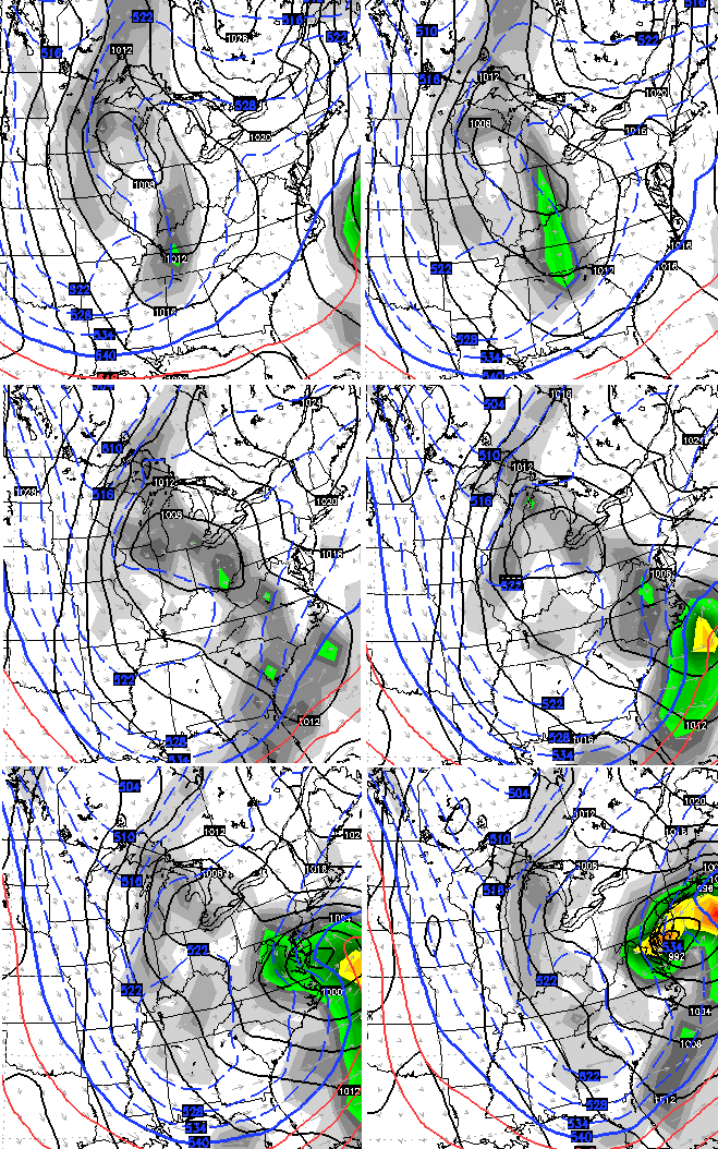
The upper levels continue to favor a wild setup across the eastern half of the country. Watch this mega trough dig into our region from Sunday through Wednesday…

Upper level setups like that often bring about harsh winter weather. The surface map from the GFS is slowly trying to figure it all out…

Notice how it has multiple lows scattered across our region into the eastern part of the country. That amounts to the model fighting with itself in trying to figure things out. It’s a few more days from that, but it’s catching up to what the upper levels would suggest.
The European Model shows a similar battle going on…
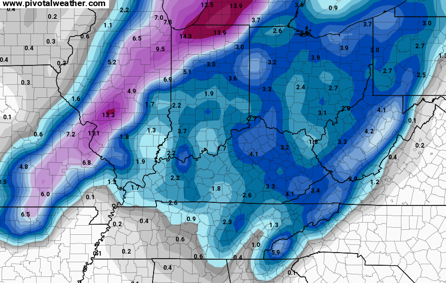
Temps from the GFS model run are frigid…
That same run of the GFS then brings the Polar Vortex toward the Great Lakes a few days later…
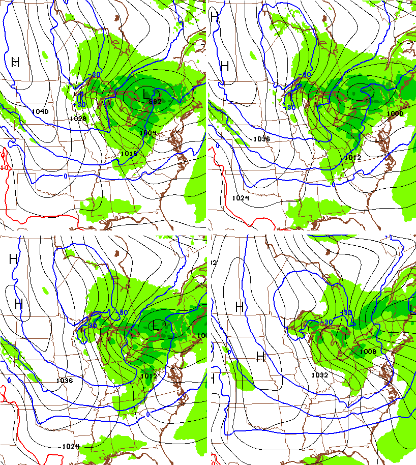
That’s some wicked cold showing up behind that…
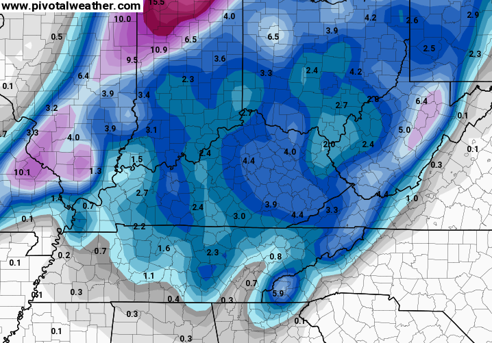
The Canadian Model has the same setup, but has the core of the cold a bit farther west with a storm introducing the bitterness…

Moral of the story… winter has a lot left in the tank over the next few weeks. Will it take things toward the extreme or give us a run of the mill period of winter weather? That remains to be seen.
I will update things later today. Enjoy the day and take care.

Winter is over –
*NOT*
My garage floor looks horrible. I wanted to sweep and mop it the other day but I said I would wait until winter is over….
“Will it take things toward the extreme or give us a run of the mill period of winter weather? That remains to be seen.”
Compare this to other earlier descriptions here of how active Feb. was described and you see this as a sudden shift.
Remember when everyone was restless for snow and the continual reminders since the winter forecast of how not to worry that Feb was really where it’s at?
Seems like a sudden shift to me. *shrug*
Let’s ask a sage.
Darth Bubba, acolyte of tone and subtext here at the blog, what say thee?
POLAR VORTEX?! 🙂 ❄️☃
CB made a reference about winter having a lot in its tank over the next few weeks. I hope that means that we are looking at warmer days after that. Average highs hit the 50s in southern Kentucky in the middle of the month and I can’t wait. Yesterday was a nice day for a walk and I wouldn’t mind a few more days like it.
Rodger likes the look of the Canadian, but fears there could be a lot of cold with just a little snow with the coming setup. Too much cold can be a bad thing for snow lovers sometimes. Rodger in Dodger!
I’m teetering on the edge of the snow bandwagon. I want to believe, but the doubts are strong. I just don’t see a lot of long term potential for snow. Too much cold bitter air and not enough moisture. I’m thinking ankle biters then Spring. Thanks Mr Bailey, I’m rooting for your forecast no matter what it is!
Thanks Chris. Just like you called it.
I’m looking forward to another shot or two of winter before we start talking spring.
I’m good on snow, but we need cold to knock out creepy bugs and allergens.
Let’s start dancing now, snow lovers.