Good evening, everyone. It’s full steam ahead toward a nice Super Bowl Weekend, and I suggest you get out and enjoy every minute of it. Winter surges back into the bluegrass state early next week with arctic cold and snow.
We’re going into a pattern that will feature a 3-4 day period of snow showers and squalls across our region. That starts Monday morning and runs through early Thursday. Northwesterly winds coming across the warmer than normal Great Lakes will combine with several upper air systems to create the widespread snow showers and squalls.
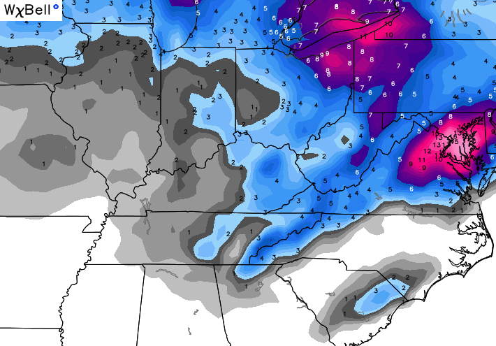
The GFS snow forecast through Wednesday…

Keep in mind, it’s forecasting that to fall collectively over a 3 day period. You may never see those totals on the ground at any one time.
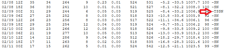
How do you know these snow squalls mean business? When I look at the raw output for Lexington and see the model showing the threat for thundersnow…
 The Canadian Model is very similar to the GFS with this setup. This snowfall map is only for a 10-1 ratio…
Our ratios will likely be quite a bit higher. That’s the “fluff factor” I often talk about.
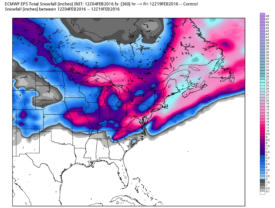
The European Ensembles show another system to watch next weekend into early the following week. Here’s the 2 week snow forecast from that model…
Enjoy your evening and take care.

Rodger enjoys those multi-day snow events. Even if minor accumulations, they scream WINTER! Rodger in Dodger
About the only complete loser or “winner” if you are anti snow is the Western KY region as the lake effect has so little effect on the flat lands in this area combined with the fact that the longitude is west of most of the lakes. Overall, the dry snows add up faster but melt quicker when the sun comes out, so we will not likely build a good ground cover through next week until (IF) we get a southern system later on.
Of significant interest, I also noticed how one low may hug the coast next week and bring some snow potential to Myrtle Beach which has been getting a lot more snow, all be it small totals, over the past few winters.
Yes!
A snow appetizer.
I seriously can’t remember the last time we saw 2 or 3 days of snow in a row without a warmup! 🙂 Sounds Cool!
Which is pretty amazing whenever you hear of the talk about “pattern changes” in regards to “artic” and “winter”, etc. Food for thought, eh?