Good evening, everyone. We’re rolling toward a very wintry pattern taking shape for our part of the world. All of this kicks off late Sunday night and will likely hang around for a few weeks, at least.
I have absolutely no changes on my thoughts for next week. This deep trough will allow for numerous upper air systems to work in here on a strong and cold northwesterly flow. Throw in some moisture from the Great Lakes and you can see the snow numbers add up.
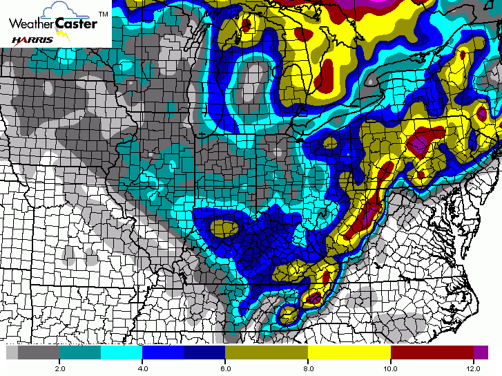
The latest GFS snow forecast for Monday-Wednesday…
The Canadian Model only has a 10-1 ratio, but still has some nice totals…
The same 10-1 ratio is used for the European Model…
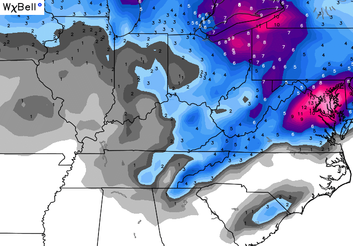
The European Ensembles from WeatherBELL…

Moral of the story… the stage is set for multiple rounds of snows that can put down several inches over a three to four day span. Arctic cold and gusty winds will also be noted.
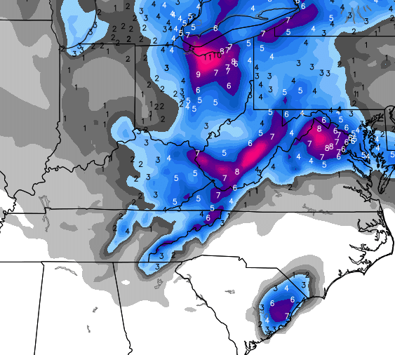
Another surge of arctic air arrives by late Friday and could bring more snow. Here’s the European model…

In my last update, I mentioned the potential for a big overrunning system around the middle of the month. The European Model says Happy Valentine’s Day…

That’s a lot of winter showing up over the next few weeks!
Make it a great evening and take care.

With a set-up like I am seeing now, I would not be surprised if a few areas don’t get close to a foot (Black Mt) and any favored areas for the “North West Flow” in far East KY. Also, I know that bad weather will be a burden to many, but I am happy to, once again, see many corrected over the dry, warm El Nino forecasted for the Ohio/Tennessee Valley regions–love it!
be cool to see how this plays out
I agree, and also, I am interested in seeing how the snow forecasted deep into South Carolina verifies or not later next week!
Man I hope this works out for us, the system around valentines day has snowzilla potential. I mean its obviously a long way out and everything has to come together just right for it work out. But models are looking much better today, who knows what they’ll look like tomorrow though. Either way looks like eastern ky gets a snow before then regardless
You mean sleet/ice-zilla, right?
The most recent GFS run has north-central and eastern KY getting 18 hours of steady sleet/ice (noon Sunday through Monday morning) before changing to rain and finally snow. Still 10 days out but it’s interesting that the European model is starting to pick up on it also.
One more big snow, than a warmup after mid month?
I am only looking at the GFS map on the Mon-Wed systems. As the other two only have the Lou Metro area receiving 2 inches. I know under a 10 – 1 ratio ti gives us more, but I like the look of the GFS map. Also, If the first few systems work out it should help hold the cold air in place for he weekend system(s). Ice will be a player over the weekend.
Couldn’t ask for a better ending to winter. Let’s get a couple of nice snows and hit average temps until summer.
Lol. What’s the deal with a snowstorm in Myrtle Beach?
I see that on the map but I’m skeptical about snow for Myrtle. NOAA is predicting upwards of 2″ of rain for them over the next few days but temperatures no lower than the upper 30s. It’s possible to see snowfall at those temps but you aren’t likely to see any accumulation.