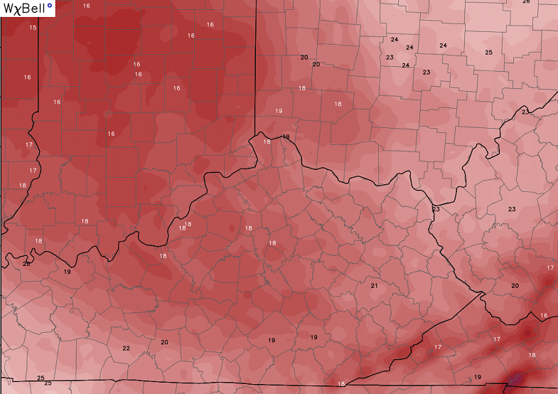
Good Tuesday, everyone. We have more rounds of snow showers and squalls across the region today as the overall weather pattern is full blown winter. Additional rounds of snow showers will hang around for the next few days as arctic air surges in here.
The heavy band of snow I was watching for earlier in the day is setting up… across southern Ohio. Areas just north of the river may get some smackdown snows early today. Grr!
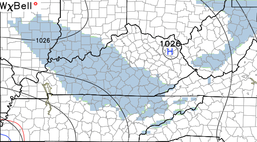
Northwesterly winds will really kick in today into tonight and that will get Lake Michigan involved. Snow showers and a few squalls will continue through Wednesday. Here’s the simulated radar from the Hi-Res NAM…

The fluff factor will be very high during this time and that means it doesn’t take much moisture to produce snowflakes. It also means the radars won’t fully pick up on the flakes. Gusty winds will blow that around. Temps by Wednesday may not get out of the upper teens for highs in some areas…
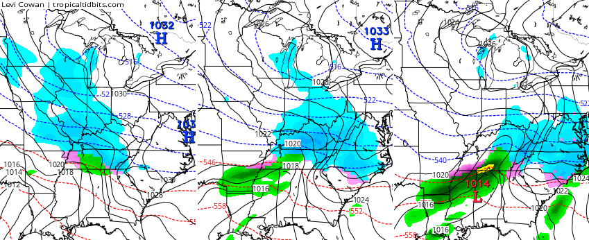
Lows by Thursday morning may sneak into the high single digits in some areas. That’s before another clipper arrives with a swath of light snow for parts of the state…
The next clipper digs in later Friday with another shot of arctic air behind it. This one should be able to produce another swath of light snow across the region…

Arctic cold surges back in for Saturday and Sunday. That’s when we focus on the next system quickly moving in here late Sunday and Monday…

That’s the latest from the European Model. The Canadian Model is similar…
That’s one to keep a very close eye on in the coming days.
Oh yeah… the European Model follows that up with another clipper a day later…

To be honest… I’m good If none of this happens. You know how I get around this time of year! 🙂
Updates will come your way later today. Until then, here’s another dose of your winter weather tracking tools…


Hamburg Area from WKYT Studio
Lexington

I-75 @ Winchester Road
Lexington
I-75 @ Iron Works Pike
Lexington
I-75 @ Clays Ferry Bridge South
Between Lexington and Richmond
US 60 @ US 127 Frankfort

US 60 @ US 460
Frankfort

US 60 @ Chenault Road
Near Millville

I-75 MP 127
Georgetown
I-64 MP 97
Winchester
Mountain Parkway near Slade

I-71/I-75 at I-275
Near Covington

I-275 at Mineola Pike
Near Covington

I-275 approaching KY 20/Airport
Near Covington

Bluegrass Parkway Bardstown
I-65 MP 32

Downtown Louisville @ 2nd & Broadway
Louisville

I-64 @ I-264
Louisville

I-264 @ Freedom Way
Near Louisville International Airport

I-75 at MP 36
London

I-75 at MP 23
Corbin
-65 @ 234
Near Bowling Green

Natcher Parkway MP 5
Near Bowling Green

Make it a terrific Tuesday and take care.

Snow is my vacation. Thanks CB
well this time of year ROLO gets arggggg when Bailey Boy says I don’t want no more snow, now u r either a snow lover or ur not. winter not over most years till mid march, so u cant have it both ways. u know I love u, but come on now.
I know right? How can you be irritated with the snow when we only got the first real accumulation 3 weeks ago? I may get tired of the snow if it is closing in on April, but I love all the weather, especially the extreme stuff!!!
I disagree completely with both of you.
Aww, come on, CB! You know we want you to love it, too! We haven’t had much snow this year at all, so I am excited!
Hey, I’m right there with yah CB, I’m pretty much over snow at this point.
That being said, I can’t see any reasonable person agreeing with your sentiment that 1 large snow event and the very modest one preceding it come anywhere close to making this a winter ‘season’.
Maybe the bold prediction for next year will be exactly how many days we’ll see meaningful snow? 2 days, 3 days, 4 days? That would be a hell of thing to get right. Go for it! 😉
Well, kids are disappointed in the lack of snow day! Perhaps tomorrow they will fare better. Looks like the small ankle biters may just be enough to keep them in there the rest of winter. I guess we’ll have to hope for a weekend system to lay down a smackdown to get use out of the new sleds and snow boots. Off to school we go kids
I’m one of the few here that prefers mild winters. The snow, ice and frigid cold from last winter alone made me want to skip this winter. Last December’s warmth helped somewhat….. while it lasted.
But I can hang in a bit longer, as I still enjoy tracking winter systems. Besides, my wife loves snow!
By the way, NWS Wilmington’s (Ohio) homepage has been frequently down since at least yesterday.
But one can still get some info from the Twitter and Facebook pages of NWS Wilmington OH (their jurisdiction includes far northern Kentucky). At least at this time, seems the Storm Spotter c-l-a-s-s scheduled this evening in Maysville KY is still on; time will tell if this snow causes the c-l-a-s-s to be postponed.
So, basically 264 and areas west of that in Louisville got a dusting, and the east end got 2″.
Sorry, MikeS, guess it’s back to you being in the suck zone again, lol.
2 hr delay for my son’s school today.
I’m right with you CB. I get ready to move on to spring about this tike of year. I will hang in there until mid-February, but then I start looking forward to warmer days. Down here in southern KY we have average highs in the 50s by mid month. I would rather have that and sunshine than a cold ankle biter snow.
Half inch or a little over for Wayne County this morning. Thelma Lou wouldn’t mind seeing another half tonight. I’ve officially decided to order the roses for this weekend, as there’ll be no snow gift it would appear. Less than a week away from the next big one…i’m guessing since talk is somewhat reserved it may not be that BIG? Sounds good to me I’m not a fan of big snows to start the week…I like them on the backside.
Another nuisance at best. One quarter inch last night in Middlesboro. Have to say that I am thankful for that. I’m over winter at this point…bring Spring!!!
So far this snow is pretty unimpressive in the Kanawha Valley. Kanawha County cancelled school last night after the NWS updated their forecast to say we would get 4-6 inches through Wednesday. I doubt we’ve even gotten 1/2 an inch so far. Better to be safe than sorry with the kids though. I just hate that now they are going to get yet another makeup day tacked on to the 5 already scheduled.
Thanks Chris. I could handle a few more snows to keep things interesting till spring. Bring it!
Somewhere around half an inch to an inch here in Carrie of knott co over night
I am somewhat surprised that CB had Ashland in the heart of the greatest risk for 4 inches last night. Only a few patches here and there, not even a full dusting. Looks like most mets expected something a little more out of this than what it really was. Can we expect anything else or just a few scattered showers today and tonight?
Im with Chris here….Bring on Spring…
I have noticed that we are not getting the NW flow that was predicted, at least yet. It appears that the flow is more out of the WNW which is not producing the upslope snow that I was thinking we would get down here in SE KY. If the wind direction changes later, we may get a good bit more, but not getting much here in Harlan yet. Oh well, it was still enough to be slick on the roads for sure which is irritating to say the least.
Chris, I’m not just “good” if none of this happens, I’m GREAT if none of it happens. I just hate the snow. I can take the cold, but not the snow.
I don’t mind these little ankle biters. What I do mind is frigid, single digit temps and not getting above freezing for days on end. This next week is gonna seem to last forever and I am hoping this will be the last blast of bitter cold.
Actually chris was right on the money with his forecast the heavy band of snow set up just a little farther then he said but he wasn’t off by much and he never said everyone was going to get a lot some people might get a dusting while 10 miles up the road could have 2 inches just that kind of storm just because it’s not snowing at your house doesn’t mean he missed the forecast.
The heavy band of snow didn’t even make it into Kentucky.
Incorrect, Drew.
Chris…you saying it’s ok if we don’t get snow is like you saying it’s ok if the BENGALS don’t win…they are far and in between, so I want every win and snow I can get. Football is over, but come on let us cheer for some wins with the snow!
Not a very logical comparison.
He said 3 day total of snow in his forecast. I think my area is certainly going to be on the low side. A 3 day total of an inch is a non event. The northwest flow this year has really been weak for snow, pretty much not worth mentioning. BTW, I am usually done with Winter on March 1 days are too long and the sun is too strong.
here in my corner of Pikeville, ky we got somewhat less than a dusting at the moment. I like a good snowstorm as much as anyone but right now I’m sooooo ready for spring time and those wonderful 70’s
He never said the heavy band would make into Kentucky he said north of I64 which is southern ohio & that’s what happen. I hope we get hammered again by another big snow people seem to forget that some of the bigger snows come in march. Don’t forget
I find nothing more frustrating than watching ask if that snow to our east just surely dissipate before it even gets close to Lexington :/ Was really hoping for at least one snow day or delay this week… Just not looking likely. Had to be the one and only school system week didn’t call it today. Ugh.
Shew… Autocorrect is awful. Should have proofread that. But yeah, y’all get the point! Lol