Good afternoon, everyone. Snow showers and squalls continue across the region, and that action will get a boost later today from Lake Michigan. This will carry us into Wednesday with even colder air moving in. That means slick roads are a given at times.
I have no changes to the Thursday and Friday ideas with a couple of clippers moving in. Those will bring bands of light snow with them, and the second one unleashes another blast of arctic cold for the weekend.
The late weekend storm system continues to send out a solid signal. The Canadian Model from late Sunday through Tuesday…
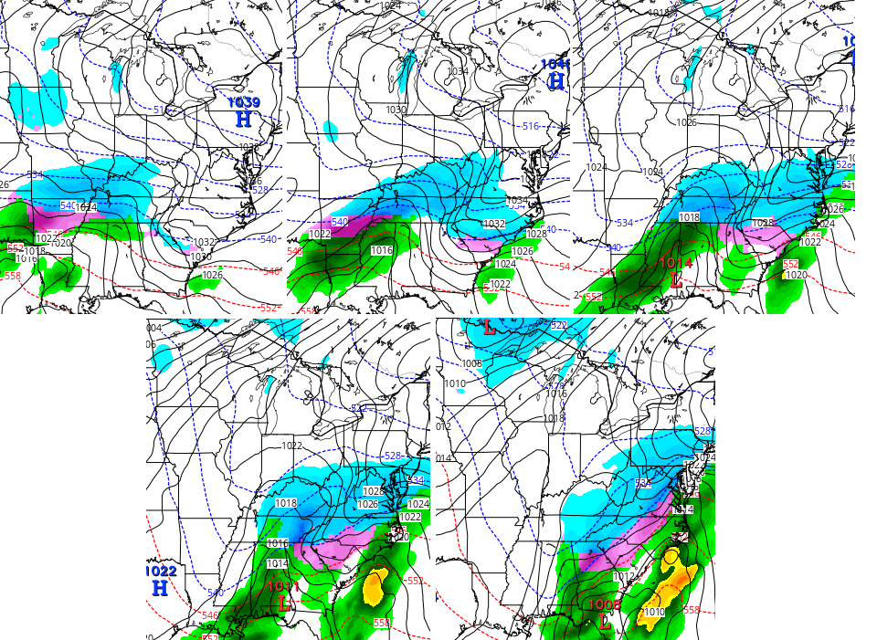 The GFS is finally starting to pick up on this, but that model is proving worthless in the medium range. As I’ve been saying, that’s one to keep a very close eye on.
I will have another update later today. Until then, keep your eyes on the winter weather trackers…


Hamburg Area from WKYT Studio
Lexington

I-75 @ Winchester Road
Lexington
I-75 @ Iron Works Pike
Lexington
I-75 @ Clays Ferry Bridge South
Between Lexington and Richmond
US 60 @ US 127 Frankfort

US 60 @ US 460
Frankfort

US 60 @ Chenault Road
Near Millville

I-75 MP 127
Georgetown
I-64 MP 97
Winchester
Mountain Parkway near Slade

I-71/I-75 at I-275
Near Covington

I-275 at Mineola Pike
Near Covington

I-275 approaching KY 20/Airport
Near Covington

Bluegrass Parkway Bardstown
I-65 MP 32

Downtown Louisville @ 2nd & Broadway
Louisville

I-64 @ I-264
Louisville

I-264 @ Freedom Way
Near Louisville International Airport

I-75 at MP 36
London

I-75 at MP 23
Corbin
-65 @ 234
Near Bowling Green

Natcher Parkway MP 5
Near Bowling Green

Stay warm and take care.

A boost later today from Lake Michigan? Anyone care to elaborate
It means a little heavier dusting. Nothing big unless you live in the mountains.
We haven’t even had a dusting up to this point. What a letdown!
I hear 50’s degrees later next week. So that means what ever snow we get won’t stick around long.
Rodger’s hoping that Sun/Mon system stays intact. With cold air in place, it’s a good setup for a good lower Ohio Valley snow! When Mr Bailey says “keep a close eye on it,” that’s his way of saying it could be a biggie! Rodger in Dodger
The Canadian model is the only one that shos snow for ky.All others show it north wih mix in ky.
That Sun/Mon storm sort of reminds me of Winter storm Octavia last year on President’s Day.
I’m thinking the cold air will probably suppress it. I could see a good hit for Southern KY and TN. We shall see
Let’s hope so before the big warm up later next week. Some long range data sources are showing the return of 60s by late next week in SE KY!
Ankle biters followed by toe biters. Snow is over folks, nothing to see here! I think winter has about wrapped up. Long range temps look to be spring like. Guess we will pack away the new snow boots and sleds until next year.
Weren’t people saying that this time last year before two 10+ inchers in a row hit? We may still get slammed.
Doubtful if you look at long range. Last year long range didn’t show temps in the mid 50’s to low 60’s.
Clyde,
Just because you can find a few models online doesn’t make you a meteorologist… Nor does a 2 hour storm spotting seminar. The “long range” you speak of is not that at all. Long range is the kind of stuff the climate prediction center puts out. The models you play with are medium range, and have been called into question repeatedly this winter. Often seeing a system 2+ weeks out, losing it, then catching it again a day or two beforehand.
Stop playing met, and the real guy handle it.
My apologies to Jamie if she took offense. However, I was just stating what I saw. I didn’t state anywhere above that I was a meteorologist.
Some folks are testy I suppose. No ill will here my weather fan friends.
This game is played EVERY year around this time or earlier
Wow! I would like to tap out of the game then. I didn’t realize people took their weather so seriously. I was just stating what I saw on my weather app. I guess you can’t share anything you read else where? I always count on mr Bailey for the most accurate reports.
I doubt winter is over but it is ironic that today is the full day of the Winter Weather Advisory and here in Fayette County it has done nothing. Yesterday we had big flake blizzard that put down about an inch in the morning, melted, and then a snow squall at rush hour that put down a half inch which has melted only on pavement due to the cold temperatures. But in terms of additional precipitation, we’ve been in the doughnut hole it appears. Still time for that to change, I guess.
Seems as if we have some dry air over Pulaski county
These little snow showers remind me of what usually falls in March. We barely have a few flakes flying. Maybe in March we get the big one?
Maybe by Monday–looks pretty impressive for a least a decent snow (maybe some ice mixed in too) for a large part of KY. Don’t be discouraged so early in February:)
Personally, I don’t care if we have any more snow or not. I’m just thankful that this winter has not been a cold 33-40 degree rain every 2 or 3 days like we have had the past 5 winters or so. Those winters were nothing short of pure misery. I’ll take the cold and occasional snow flurries any day over that but I am definitely craving some “dry”, warm Spring days.
5” here in athens ohio
Monday looks interesting. It probably won’t be like the huge storm we had a few weeks ago. However, compared to the clippers we see this week, it looks somewhat impressive.
The snow dome over central Kentucky is showing up again in a BIG way… ugh :*(