Good evening, everyone. This active winter weather pattern continues and will try to ramp it up a notch this weekend into early next week.
Our first system is an arctic front that arrives Friday into Friday night. It’s looking more and more like that will have a band of snow accompanying it across much of the region. Light accumulations could cause some Friday evening as winds gust up. Temps behind this crash into Saturday with more snow showers and flurries.
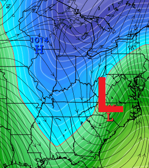
The forecast for late Sunday into early next week continues to be on to keep a very close eye on. A storm system is likely to develop and work across the Tennessee Valley. That system then likely turns the corner and rides up the Appalachian Mountains.
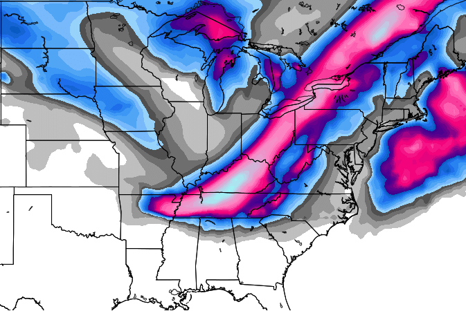
Many of the latest forecast models show a powerful storm winter storm developing out of this. The European Model…

The snow map from WeatherBELL from that run is farthest north of any of the models…

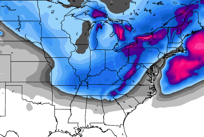
The control run of the European Ensembles from WeatherBELL…
The average from all the European Ensembles members suggest some disagreement on what to do with this, so it broad brushes everything…
Two other models I look at show some very interesting looks. Check out the JMA…
The UKMET has an even wilder look…

I will update all of this potential later tonight. Until then, you know the drill…
I leave you with your tracking toys for the afternoon…


Have a great evening and take care.

I will take snowstorm map door number 2..lol
That control run of the Euro ensembles! What a smack down right through the center of Ky! Bring it!
I don’t have the scale memorised… How much?
I think when it goes blue it’s approaching 20 inches
I mean the whitish-blue patch in the center of the pink
You guys must not have kids out of school for this stuff lol! J/K, my grandkids love it 🙂
That sure does look good for snow lovers in Central Kentucky .. chris,What is your take if rain will be a part of the storm
Well hotdog, that’s what I like to hear! Fingers and toes crossed that this little system develops into a big something. We’ll be ready to grease up the sled!
So… the European control snowfall map is a done deal right? LOL 🙂
Amazingly even another Lex station mentioning it bears watching Monday but they don’t know what to do w it thinking maybe snow to rain. Of note their lead Met is off tonight so if he were there would not have even been a mention of it. Too early to tell yes yes but regardless of whether it pans out or not gotta like that CB at least put it on the radar screen….no pun intended!
Not looking good for SE KY for hardly any of the recent model updates, but that is the usual for this part of the state:(
I hate to see that warm punch of air bring more ice and rain to the SE region again.
Getting sad as we get closer to Monday with such a NW shift, but that was expected and may continue to shift as we get closer to the storm!
The European shows SE Ky. getting mauled again lol
Only the control run, but is still shows much less here than in Central KY. Plus, there will likely be too much warm air drawn in if it tracks as far north as shown in East TN. Hopefully, it want be another miss, but regardless, it is going to be a huge warm-up right after the storm moves out. I wish we could have gotten a big storm with arctic air behind it this week rather than the mild air rushing in later next week. We will just have to take what we get!
Thanks for the nifty update, Chris.
Gonna be some fun watching how the Sunday system evolves!
Maybe Louisville will get some big totals this time, they was pretty much left out during last month’s event.
Rain > freezing rain, ice
Guys it will be Louisville north lol waa will win in Kentucky plus some of that will be sleet so totals won’t be too high.
That was some wonderful eye candy for central KY folks like myself!
I feel like I’m going to be hanging on for the next model update each and every day until Monday!
I’m not going to get to high or too low this time. I will wait until the storm arrives on land . I refuse to chase the shiny objects on the snow map this time.
I know what you mean: It is addicting and usually ends in heart break (LOL)!
Really looking like frzz.rain and sleet for much of Kentucky and even southern ohio.with wrap around snow .half Inch of ice and 2inchs of snow a good bet.still a serious storm.
Based upon……? A crystal ball?
Nothing to see here folks….move along
I am a snow lover, but I am supposed to be having surgery Monday and leaving to travel to DC Tuesday… so this is the one time I’m hoping it doesn’t pan out (or at least that the major snow holds off until later in the week!)
It is what it is at the end of the day. Will this be a big storm? I don’t know, but at the end of the day, there’s nothing we can do about it. It is what it is!
LOL – sorry
This site just cranked out a bunch of followers once again!! I love it!! You guys saying there is nothing to see here, or rain, etc. I’m following along until CB makes those statements! Gonna be a fun couple of days!
THE COLD air in place will win out SOUTH KY rain.mix to snow. SE KY quick switch over to snow. its slowed down a lot meaning this bad boy going get stronger as we get closer. I see 8-10 inches for the area Central/eastern/se ky. that could change, but I like what im seeing tonite.. join us at Fans of Chris Bailey facebook page for more talk.
Hoping for decent weather the weekend of 2/19-2/21 for a drive down to Nashvegas and back.
Evening all. Just dropped by to read Chris’ update and subsequent comments. Not going to speculate because I am a weather lover and watcher, not a prognosticator. There seems to be many of those in the comment section tonight. I enjoy reading the opinions and speculations from everyone. But I gotta tell ya….. None of you can come close to Chris when it gets down to it. Have a great rest of the evening and please don’t take this comment in any other way than tongue-in-cheek.
In the forecast discussion of Louisville NWS they said that they would lean towards the GFS solution versus the Euro solution. They said it is because the GFS has proven more reliable this winter. What? 😐
So it looks like two years in a row with a Presidents day weekend snow storm. Traveling to St. Louis for volleyball tournament Fri-Mon. Last year at the same tournament several teams had to stay and extra day and few travel back to Louisville and it took nine hours. I like the looks of the all the maps above. This has been on the maps for the past week. Cold air in place will make this a snow to remember for some.
There is NO MODEL AGREEMENT when it comes to comparing the GFS to the Euro. The 00z of the GFS is out, and it still has a long way to go to agree with the Euro. I think the GFS is out to lunch. The European is a whole lot better over all.
Completely agree.
I’m a snow and cold hater, don’t like any of it. But when I want to know about the weather I come here. For 2 weeks CB kept saying Jan. 7-11 was going to be bad and we was going to get in a deep freeze, when no one else was. He was right, I just don’t know how he does it. I do love reading all the comments on here and have noticed that several on here really are smart when it comes to the weather. I love this blog but I still don’t know how CB gets any sleep with all these updates…..Thanks Mr. Bailey.
New GGEM puts most of the state 7+
Wonder what the Master Blaster Weather Forecaster has to say about this one #FrankKnows 😀