Good afternoon, everyone. Things continue to look very interesting as we head into the weekend and early next week. Bitterly cold air could be followed by a significant storm system impacting our region. My trigger finger is already getting itchy on this one! 😉
Let’s first talk about the arctic front arriving later Friday. It looks more and more like a band of light snow will introduce this front into the region. The flakes may start as early as late tonight or Friday morning and continue into the afternoon…
 There’s a little disturbance embedded in all that and this may be more than enough to put down some light accumulations.
Once the arctic front actually swings through Friday evening, northwesterly winds are likely to cause snow showers and a few squalls to break out…
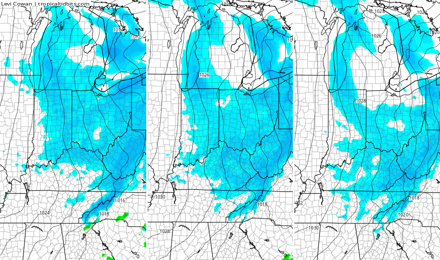
Additional light accumulations will be possible as winds howl and temps crash. Single digit lows are possible by Saturday morning with a wind chill below zero. Highs Saturday likely stay in the teens for many.
This takes us into Valentine’s Day and the potential for snow breaking out well ahead of our storm system. Don’t be surprised if we get a band of light snow to streak eastward across the region during the daylight hours.
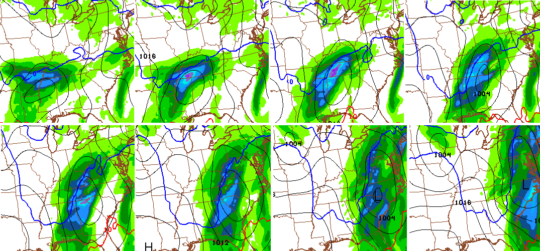
What happens with our developing storm system? That’s the question I will be tackling later today and into the weekend. The Canadian Model is going toward a significant event for much of the eastern part of the country…
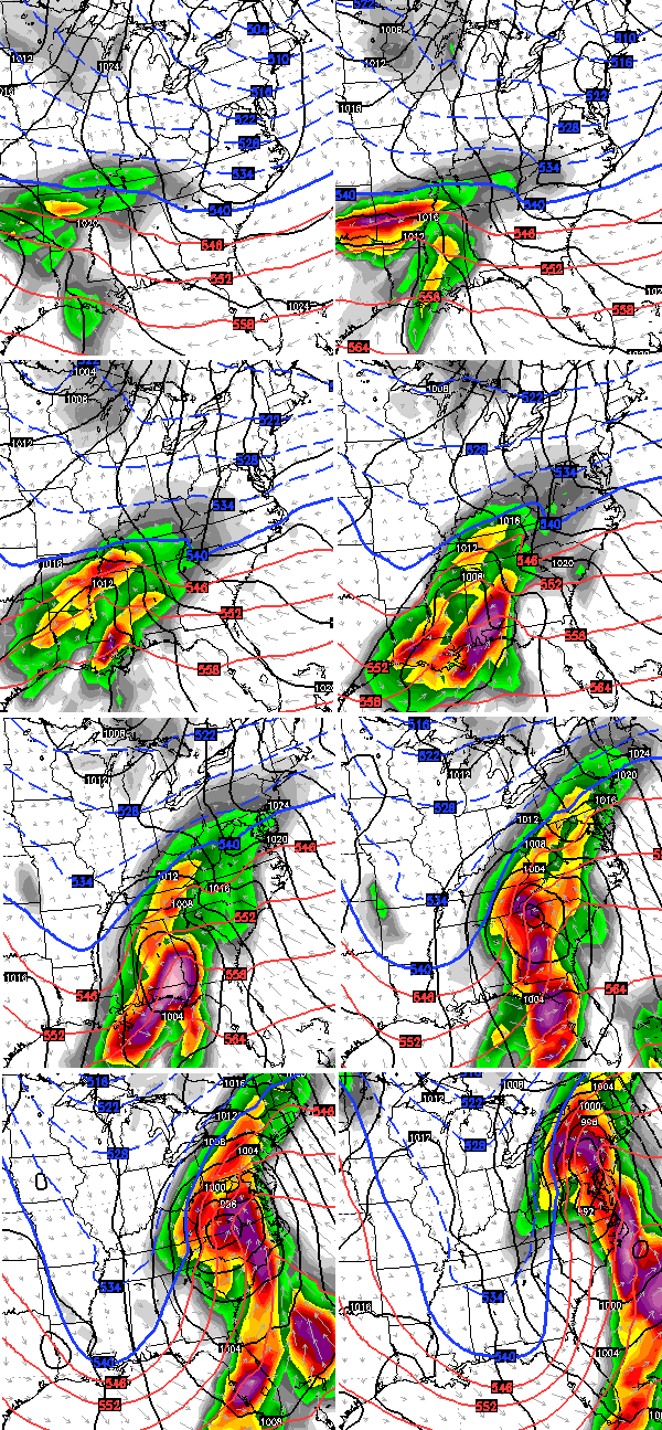
The models change from run to run, but that’s a look I’ve seen on several other models in recent days. The snowfall forecast from that one particular run…

THAT IS ONLY A COMPUTER FORECAST! It should NOT be taken as 100% true. I’m showing this because that’s what we do on the blog… show you the things I’m looking at.
The GFS is finally seeing this storm system…
The low-level temps on that model are pretty much garbage. We can’t ask too much from a model that is JUST now seeing this setup after all the other models have been showing it for a week.
What do I think of this storm potential? It’s way too early to get specific, but I do expect some kind of impact across Kentucky. Does this mean a little snow or a lot of snow where you live? I can’t answer that at this point. I’m not saying you’re getting a winter storm, but I’m also not saying you won’t. It truly is all about the strength and track of the low. How’s that for honesty? 🙂
I will have the very latest on WKYT-TV starting at 4pm, and will have another update on here this evening.
Enjoy the afternoon and take care.

Thanks CB! Fingers crossed!
Will be fun to track. A couple model runs over the past few days have had the Ohio River as the sweet spot. I like the way this is playing out with the models. Moving back to the South just enough to put us in Louisville on the Northern fringe. Let that hold true for the next 48hrs and then the NW Shift can happen and put the sweet spot back along the river. Get your syrup ready going to be some waffles over the next few runs.
Sorry snow lovers. I’m hoping for this thing to either not develop at all or for the NW shift to take this thing well into Indiana where it belongs. Looking forward to mid to upper 50’s or low 60’s late next week.
You’ve got all spring and summer for that. Whats your hurry?
Thanks CB! In spite of all your cautionary efforts, some with selective reading will still do what they do 😉 🙂
my thoughts are 6-10 INCHES with start of a mix to snow. join us a Fans of Chris Bailey facebook page!!
Oh boy, I am not sure I want this thing to pan out like that last model run. We was hit hard with the last big snow, picking up 18 inches. I am starting to get snow fatigue, I am ready for spring.
Some of those models looking similar to the BINGO snow much of KY received three weeks ago! Rodger loves tracking this stuff; he also reads a lot of met blogs, Facebook posts, videos etc and none of them are better than Mr Bailey! Rodger in Dodger
I look for this one to move near the Ohio River. At this point, who knows. Something else fun to track!
Chris says 18″ for my back yard. I can’t wait to go spread the news to everyone
He said only a trace in my back yard, haha
We are only 3 and half days away , I understand chris that you don’t want to say what you think will happen, because in today’s world people take that and run with what you think will happen and say it Will happen.
But to be honest if we COULD keep our mouths shut, it would be nice to know at far out what you PREDICT will happen.
But we will continue to watch and see and get better handle later …i hope your trigger finger don’t get stuck…i hope you pull it soon
Even TWC has ky in the sweet pot for snow.
then it wont happen
Let’s not even think that way. 🙂
When will the models become trustworthy with this storm? Tomorrow?
Saturday Morning when it finally coms ashore.
With this type of setup, a measure of residual Arctic air and a low that will have abundant access to the Gulf of Mexico, the medium range models will have constant difficulty in ironing out the details for our part of Mixed Precipitation, USA.
Another words folks. Something is going to happen. The question is what. Some people are going to get a lot of precip. The question is where. Welcome to the Ohio Valley.
And what type!
Touche’
If those snowfall maps turn out correct that will mean somefolks approaching 40 inches in 2 storms,
unheard of in these parts!
Did that last year in EKy. We had two major storms to hit.
If you look back to the early – mid 90s you will find we got some big snows around MLK day & Valentines Day. January’s snow was the end of week for MLK. We know what Sunday is. Snow forcasts for those times always scare me. Hoping it all misses us.
Does anyone else find it difficult to get excited about a big snowstorm when a big warm up follows the snowstorm?
I do also find it difficult to be excited…
This. A combination of being big snow jaded and shovel weary 😉
Seems sleet (hopefully not ice) could be a player for a lot of folks- if it pans out, of course.
I get more excited about the big warm up. Would like to see that without any snow involved.
I smell a cutter, CB, but I’m hopin’ middle TN can stay in the cold sector long enough. No more NW trend for me.
Another OLD SCHOOL coming to town!!!!! some biggest snows come after mix period then to HAMMER TIME!!!! Fans of Chris Bailey facebook page tracking the weather!!!join up..
Like I said yesterday.. the big snow will be north of Louisville in Indiana. South of Louisville plain cold rain.. WAA always wins… take it to the bank
Yeah Josh….Just like last years two big storms.
And this year’s 😉
I think a lot of Kentucky will receive freezing rain, with south eastern Kentucky getting a lot of rain. I`m hoping Shepherdsville is all snow and lots of it.
I am in Rolo’s corner. This COULD be an OLD SKOOL event.
I’m in Louisville, 1/8 mile from the Ohio river near downtown.
I see and feel it coming. Along the Ohio river is going to be the swwweeeeeettttt spot. At least I hope 🙂
Thanks for all you do Chris. You go above and beyond everyday.
I think you should have a sainthood. ALL hail Saint Chris
LIKE….I am in Schnitzleburg and I am thinking it will trend NW as it gets wrapped up and strenghens. Won’t know until sometime after tomorrow night or Sat. morning. Hope we are correct and the OHIO river counties get the smack down.
I`m originally from Germantown ,many years ago.
Let’s bring it a little farther south to central KY cuz!
All rain for kentucky and even southern ohio.temps just above 32.
Wanna bet?
I like that reply.
10$ On the meteorologist!
My money is on Chris!
I’ll put my house up on what Chris Bailey says
Like! But I have noticed wkyt Temps for Monday gone from 28. Now to 32….where is your bet line in ky (where do u think it will mainly rain?
If in Tennessee, maybe.
The low is for now looking Tennessee bound.
I’m liking all these comments a few days before an event. Good times, y’all. Thanks Chris.
Love when this blog is getting ready for a big storm!!!!! Bring on the SNOW!! Hope we get 20 or more inches!!!!! My family loved the last one. Hopefully Chris will be putting this site into full winter storm threat mode soon!
Nws backing off the threat in there latest discussion. Saying more of a rain scenario
The big storm looks like more of a rain event for Southern KY according to the 5:00 forecast
Hopefully not the ice type.
Thelma Lou always pulls for the mudder when there’s a chance the iceman cometh!
Let’s hope louisville and the surrounding counties in indiana receive at least a foot of snow!! Seems like eastern Kentucky receives more snow than we do. They have an elevation advantage, and are in an area where they receive snows from East coast storms. Lucky for them.
Will central ky get any snow anyone
how about along ohio river or just north? Rain? Snow?
I think snow….
Loving watching the model runs! Would love a big snow here in the ‘Ville before spring officially arrives!!! As a teacher, don’t want to be in school until the middle of June, but love the outdoor winter activities with my daughter. The only other place besides Nebraska that we can experience all of the seasons and crazy weather!