Good evening, everyone. Harsh winter weather pattern rolls on across Kentucky. That’s basically the headline and is something I’ve been trying to drive home now for the past few weeks. Light snow, bitterly cold temps and a potential winter storm are on the weather menu for the next several days.
We have a quick-hitting light snow band targeting the southern half of the state late tonight and Friday morning. Light accumulations are possible with this, but it may be enough to cause some slick travel to develop. A Winter Weather Advisory is now out for the southern half of the state because of this possibility…

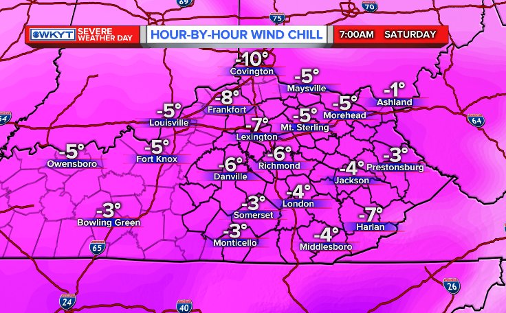
Snow showers and a few squalls will then kick in across central and eastern Kentucky Friday evening into Saturday morning. Light accumulations will be possible out of this.
The cold and wind chills take center stage. Look at the numbers from the NAM by Saturday morning…
From here. our attention turns toward a developing winter storm possibly impacting the region from later Sunday through Tuesday. The models are throwing an initial band of snow our way Sunday afternoon and evening. Here’s what the NAM has for that…
 The main storm system follows that up Monday into Tuesday. The track on that is likely to work across Tennessee before turning the corner up the eastern slopes of the mountains. The operational models are trying to figure out how to play this system and seem to be struggling in how to handle the temps. The new run of the GFS is catching on to the cold more than earlier runs…
 Take those with a grain of salt as I think it still has a lot of work to do with the temps as the storm comes in.
The European Ensembles from WeatherBELL show more of a statewide impact…
 The control run hammers central and eastern Kentucky. We’re still a bit away from the models fully understanding the depth of the arctic air ahead of this storm.
I will have another update and likely upgrade coming tonight. Enjoy the evening and take care.

Jump ball.
Looks like the models have back off of a big impact. But if I’m right the same thing happen the last storm. I’m not taking these runs as of now with three days to go.
Thank you so much for taking the time to update us three times a day in the recent weeks. I think it’s safe to speak for everyone when I say we really appreciate it!!
I’m not liking central and western KY getting the shaft on that GFS run. Yuck! No thank you.
Need SNOW!
Thanks Chris. Looking forward to seeing how this develops. Appreciate all you do. Have a great night all.
Just when we thought we were finally going back to school…..oh well. Tomorrow’s inch or so will keep the busses of the road and Laurel looks to be in the heavier end of the possibilities for the big storm. Time for more puzzles.
Are we seeing snow on the radar that reaching the ground? Looks to be developing early.
Good evening. Dew points and humidity levels related to current temps are way apart. Equates to a very dry atmosphere. Will be quite a while before precipitation reaches the ground.
Dew points and Temps are identical at least in my backyard
Again really looks like plain rain for southern and central ky . Rain and sleet for northern ky.and southern ohio.central and north east Ohio looks to get all snow.
The reason for my thinking is in contrast from the last storm the high pressure is absent and suppression of this storm is not likely. There for mostly rain is likely.
Hoping this system materializes. Looks like all the ingredients are there. That low needs to track across TN, we need to keep the cooler temps, but not too much dryness, no warm air aloft, the models need to all come to agreement on one last thumping for CKY.
I mean we did get new sleds and snow boots we’d like to use.