Good afternoon, everyone. It’s full steam ahead toward a harsh weekend of winter weather across our part of the world. Snow showers, below zero wind chills and the potential for more snow and a winter storm highlight the forecast.
This morning’s snow in the south is winding down. Now we wait on snow showers and a few squalls to kick in from the northwest as arctic air floods in…
Light accumulations will be possible this evening into tonight. Winds are going to crank as temps drop to around 10 degrees. Wind chills drop to 0 to-10 by morning. Highs stay in the teens for many on Saturday.
Snow breaks out quickly from west to east by midday Sunday…

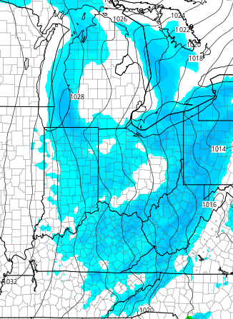
We have one system diving in from the northwest with another storm developing across Texas. How these two decide to play together may wind up being the big determining factor on just how much snow we get from this point on. Initially, they combine to throw a shield of decent snow across the entire state into Sunday night…

The NAM keeps the northern stream system a little stronger and that keeps our main storm just a littler farther to the south and east by late Monday…

Even with that scenario, the NAM puts down some nice snow totals…

t actually has a wide swath of 3″-6″ across the region with locally higher totals in the southeast.
The GFS has the same snows Sunday into Sunday night and also wraps up the main storm just to our east by late Monday…
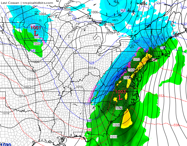
Snowfall through Monday from the GFS…

The usual model bias from the GFS is to be too far east in a setup like this. That doesn’t mean it will correct westward, but we have seen this happen NUMEROUS times in the past.
The Canadian snowfall map looks similar to what it was showing last night…

It has quite a bit of snow across our region, but looks too disjointed for my taste.
Here’s my take… I want to see what the European Model does this afternoon and then I want to see what tonight’s 0z runs do. This will get us within the 48 hour window when true trends usually lock in. I’ve seen similar scenarios to this one wait until within 24 hours to show these true trends. This actually reminds me some of the storms we had several years ago… The ones that had us in the snow sweet spot until the day before and then putting that to our north and west some. Well, we aren’t in the model “sweet spot” right now… that’s just to our east and south.
It’s going to snow and the entire region will have snow on the ground Sunday into Sunday night… a few inches to several inches. Can we get this storm to come together in a fashion to take this thing to another level? That is still a possibility and one we have to be mindful of.
I will try to update this evening, but I’m emceeing Father Daughter date night at UK Gymnastics. Who am I kidding? I’ll find a way to do both. 🙂
I leave you with your tracking toys…


Enjoy the afternoon and take care.

Thanks
Go west snowman.
Still hoping for a severe MW shift. i would be happy with mostly rain at this point. Never thought I’d say that snow is on my nerves. Over it…
Thanks Chris flakes are flying now and very cold. I hope for a big one but we will see I have seen the warm air enough to make a believer out of me it can show up at the worst time at the party and cause trouble for snow lovers. Enjoy tonight and the time with your daughter that’s what counts family. Does she like weather as much as the old man lol? Thanks for all you do.
Thank you for the update. Have fun tonight.
stinks there’s not a big high building in behind this thing. If there was, we might at least get some snow on the back side of it down here in Tennessee.
This is one of the few times the NW shift is our friend.
Where are the typical maps showing qpf of sleet and frz rain that Chris will normally post?
So will Central Kentucky get hammered with the storm anyone on Sunday
Looks like the uro cuts and runs the Apps.
That would be Euro..he he
Do you have map?
yes
are you able to share it?
Sunday thru Tuesday morning 6-10 inches of snow area wide. Fans Chris Bailey facebook page join up.
That’s a real bold prediction but I like the optimism
I`m hoping Shepherdsville receives at least 8 inches out of this system. An App. runner would be awesome, although I`m afraid rain or freezing rain will be an issue.
Hoping here in the Pikeville area we see some decent snow. Here in Belfry we have been lucky lately (for snow lovers) and i hope that trend continues. Thanks for all you do Chris! Even though I live in Kentucky all my local news channels are out of West Virginia so your blog is a great resource for me and others in my area. Thanks Again!!
Well Mr.Bailey, I’m hoping for this NW shift so we have a possibility to be in the “sweet spot” but if not then I guess I’ll have to deal with it… gotta get my senior year over with sooner or later.
(P.s have fun tonight)
I am not doubting Chris on the snow potential but I ain’t seeing it being more than a couple inches or so for the lexington area. them streets and roads people been clearing em pretty good. i hope those in our area are not counting on any snow days. Ain’t no school on Mondaycause its lincoln or somebody birthday they will probably have everything cleared and ready for em by tuesday. I hope that this is the last of winter my old lady dont want to shovel are driveway anymore this season. Soon spring will be here and I will have to convince her to push mow our yard. she aint ready for that either.
Charleston mets are saying that the latest runs are coming in warmer.
Thanks Chris! We got 1 + 1/2 inches this morning.
I`m afraid we`ll get very little from this system. If the GFS pans out, the main low will go too far south and Bowling Green may receive something, but Shepherdsville will get very little if anything. If the Euro is correct, then we`ll all see rain, changing to snow later or freezing rain. It shows mid 30`s for our area, but I think it will be more around 30 to 31, which gives us freezing rain to snow. We`ll see.
Trust the European model on this one
CB’s point I think and without being accused of hyping is this system looks the opposite of the ones that usually miss the area. These type of systems that usually show us in the sweet spot now- miss us.
That said, even if we are more in the main flow, the mix factor is the wild card.
Could it finally be a SEKY sweetspot?
When is the “most accurate” window for forecasting usually? And thus far (this winter) what has been the most reliable model? I’m guessing it’s <48 hours and the Euro but it's hard to keep up with the wealth of knowledge we have here.
I'm just curious if anyone has semi-tracked what's seemed to work this winter.
Hats off to Mr Bailey. I wouldn't want his job! Sure is fun tracking with you guys though!
Does anybody besides me have trouble dropping off the site with an iPhone. Seems like every since Chris started using the interactive radar I’ve had problems.
Same thing happens to me all the time! Anymore, I avoid using the site from my iPhone unless I’m just really itching to get an update.
i downloaded the Chrome app and go thru there for this site. Safari didnt like the interactive.
Yes, it’s been happening to me for a week or so.
Models have Whitley/McCreary with a dusting to an inch. Knowing our luck..We’ll probably get all freezing rain/sleet. 5+ to the north east south and west of Whitley/McCreary county, now that’s indeed complex
I bet the gfs trends West on the 18 z run. We will know here shortly.
Chris had 3″-6″ for Sunday`s snow in BG. Regardless of Monday`s outcome I will be happy with just the 3″-6″ forecasted for my area; however, if we get another foot I definitely not complain.
Can u post his Sunday map? Cannot find it on Wkyt. Thanks
What exactly is “the entire region” that will have snow on the ground?