Good afternoon, all. I will get you another update in a couple of hours, but I wanted to drop by for a quick update on how things are looking with our Winter Storm THREAT for Sunday into Monday.
I have no changes to my initial thinking. Snow develops quickly from west to east Sunday into Sunday night with a few to several inches likely. Then we watch to see what happens with the Monday part of the storm.
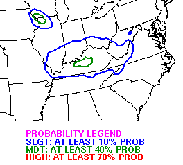
The WPC has the entire state in the risk area for 4″+ snowfall over the next few days…
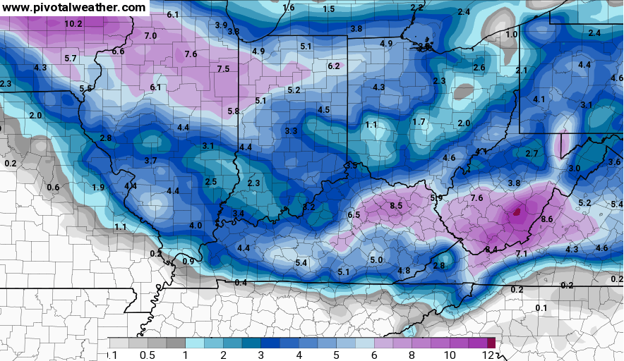
 The NAM continues to be a steady model in what it’s forecasting. Here’s the current model snow forecast through Sunday night…

It adds to those totals for some with the Monday part of the storm…
The GFS continues to give us a different look with each run that comes out. That’s pretty incredible it can’t settle on a solution a day away. Still… it shows this for snows…

I’m getting asked why there are no Winter Storm Watches or Winter Weather Advisories anywhere in Kentucky. I can’t answer that. We’re within 24 hours of the first snows starting… and nothing has been issued… for a holiday in which many people make dinner and travel plans.
I will update the snow maps in a few hours. Take care.

Where is your 1st call for snow? People have been asking for that as well. 😉
CB might not be to comfy with the models. Either he is winter weary, or not too confident in them.
I know from your past posts that your an analyst of some sort but I wonder if you’ve ever dabbled in psychological analysis before. Just a thought. 😉
Everyone is a critic and a psychologist 😉
Ha! 🙂
He said 2 to 4″ for i64 corridor and north. South of that was 3-6″.. I would start watching WKYT. He put it out yesterday afternoon.
Thanks for the update. The nws will hopefully do something by mid-afternoon. Churches and others need to make plans, esp for Sunday night since this is the Valentines weekend. The earlier we get news the better we are.
Thanks CB for all you do! We are supposed to be going to a birthday party tomorrow evening from 6-8, not so sure about that now. Wish local Mets would say something about their thoughts on timing.
Louisville is saying 2 to 4 inches for Sunday. A dry snow starting out then wet snow towards the end, which tells me the temperatures will keep climbing. With a 36 degree high on Monday, most of that snow will melt. They are saying rain on Monday, but that could change.
I guess no warnings are being issued because no one knows. 24 hours away and no one knows whats going to happen. Amazing
Thanks for the update CB! This is a HUGE weekend for people getting out and about, especially tomorrow. I have a feeling a lot of updates from the NWS and you hardworking mets over the next 24 hours or so!
I think this is the worst model inconsistency I have seen not only this winter but last year’s storm forecasts as well. I still agree with many others on here that more information should be given as, without CB, we would be getting nothing useful from our local news in KY:P Most are saying “light” snow for Central and Eastern KY with a mix of rain for Monday–not very helpful is it????
Agreed. So confusing!
Thanks CB!!! I’m from Franklin meteorologist is saying in my area light snow changing to rain. I keep my trust in you. Hope all went well at the father/daughter dance. Waiting on the next weather update.
Chris, maybe there are not any advisories out because the NWS is afraid Simons will call a technical on them! (Sorry, couldn’t resist that.) Anyway I guess they are all looking at the GFS….
Thanks for the update. Looking forward to the next one.
At this time, a Winter Weather Advisory has been issued (by NWS Nashville) for north-central TN, including Nashville. But no winter advisories/watches issued for KY.
NWS Louisville has issued a Winter Weather Advisory now for Kentucky. They’re issuing a general 2-4 inches it looks like with the switch over to freezing drizzle and then rain for Monday for Central Kentucky.
Advisory just issued by NWS LOU.
I guess my guess of Cats by 8 wasn’t accurate. I hope my guess is off on snow totals too! Bring on the big numbers!
I’m confused…ok easy for me, I know. Jackson NWS expects 3-5″ for Sunday into Monday morning with a WW Advisory. In Louisville, that’s Warning or Watch criteria if an average of 4″ is expected over a 24-hour period. I do know that some weather offices hold to different standards as far as criteria but thought Jackson was the same as Louisville. I guess not….
There. I researched my own misunderstanding. Louisville and Jackson issue Warnings at least for snow when 4″+ will accumulate over 12 hours and/or 6″+ over 24 hours.
Up to 29 so far today
thanks chris!! keep on keeping on with the forecasts (Y)
No, mater what the NWS says, the bottom line is our man CHRIS :]
Does anyone have recent maps??
Is that unmet map showing all rain for us??