Good afternoon, gang. Our winter storm continues to work across the bluegrass state, and it’s looking pretty impressive. The thundersnow I talked about a few days ago has already been reported in western Kentucky. There have been reports 3″ in a little more than an hour.
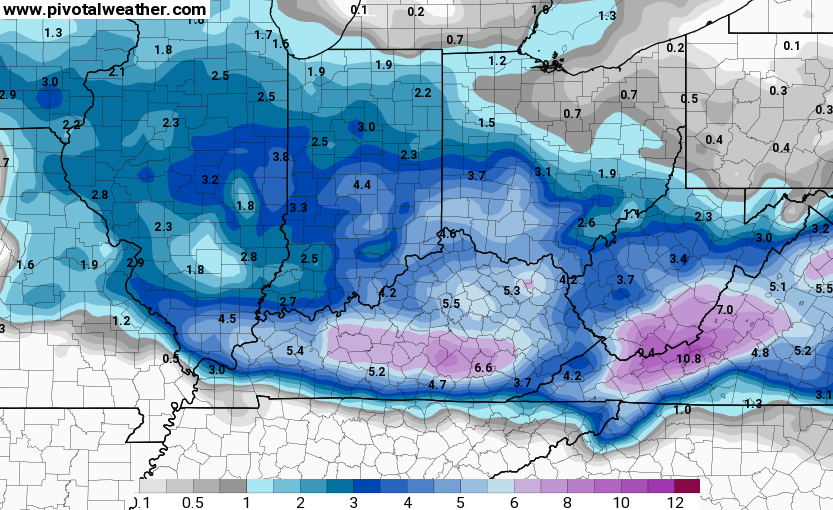
Based on actual trends of what’s happening, and the fresh model data… here’s your Last Call For Snowfall…

There will be some places in there that come in closer to the high end and some that come in closer to the low end. There could be some spots that come in just under the forecast totals. One area to watch is far southeastern Kentucky near the Virginia border.
The last model forecasts as the snow moves in…
NAM
GFS

I have you all set to track and will check back with updates as needed. I will also be blowing up your twitter feed on @kentuckyweather
Track away…


Hamburg Area from WKYT Studio
Lexington

I-75 @ Winchester Road
Lexington

I-75 @ Iron Works Pike
Lexington
I-75 @ Clays Ferry Bridge South
Between Lexington and Richmond
US 60 @ US 127 Frankfort

US 60 @ US 460
Frankfort

US 60 @ Chenault Road
Near Millville

I-75 MP 127
Georgetown
I-64 MP 97
Winchester
Mountain Parkway near Slade

I-64 Near Morehead

US23 at 119 Near Jenkins

I-71/I-75 at I-275
Near Covington

I-275 at Mineola Pike
Near Covington

I-275 approaching KY 20/Airport
Near Covington

Bluegrass Parkway Bardstown
I-65 MP 32
Downtown Louisville @ 2nd & Broadway
Louisville

I-64 @ I-264
Louisville

I-264 @ Freedom Way
Near Louisville International Airport

I-75 at MP 36
London

I-75 at MP 23
Corbin
Owensboro

-65 @ 234
Near Bowling Green

Natcher Parkway MP 5
Near Bowling Green

US 41A Gate 5 Fort Campbell Entrance
Fort Campbell
I-24 MP 4 @ US 60
Paducah
Louie B Nunn MP 3
Near Glasgow
Happy Valentine’s Day and take care.

Looks awesome chris, but…..no mention about monday/tuesday. … what’s ur thoughts, seems everyone else says rain, what about your thoughts?
Perhaps not mentioning it speaks enough. Cold, cold rain.
12z models are beginning to think otherwise. Time will tell.
Shhh! I’m baiting CB do give an answer 😉 🙂
lol I know how Bubba works! Honestly, tomorrow and tomorrow night is a 1-2 degree difference between rain and heavy snow. Tough call.
Chris, just answer me this and I’ll be able to enjoy my Sunday nap……Is there a chance that tomorrow’s rain could remain all snow? It would be such a peaceful nap knowing that is the case.
most forecasters are saying more rain than snow
Very likely if CB thought snow, he would mention it. Probably does not want to rain on people’s snow parade today.
BubbaG, I think you’re on to something there! 😀
We are (im)patiently waiting the main event. Just a light snow at our house in CKY. Hoping we are more on the 8″ than the 4″ before the rain comes and washes it all away. Thanks Mr Bailey
About 4 1/2 inches of snow in Hopkinsville, starting to switch to icier stuff now.
We’ve had flurries flying pretty quickly here in Lawrence Co. for over 30 minutes now.
Unless it starts filling in from behind, Central KY, Versailles and Lexington in particular don’t look to see to see much.
2.5-3 inches in Southern Warren Co as of now. Roads are an absolute mess ! When is this thing supposed to wind down today ?
Thanks for all the insight CB! Keep up the great work!
Oh no, is it the return of the snow dome in central KY? According to radar, it’s been snowing impressively over Fayette County for an hour and not a flake has made it into my yard in southeast Fayette.
I don’t want the dry air to eat up all the pretty snow.
And unless we see one of those intense snow bands, I don’t see how we can approach even the low end because we’re seeing the end of the snow shield on radar already.
I just have to believe, have to believe, have to believe . . . .
Southern and SE Ky deserve one too!
Right on! As of right now, it looks like the Southern half of the state will get the most through early tonight, but no one looks to win tomorrow:(
Hate to be a negative nellie, but if this underperforms, I’m good with that.
I’m right there with ya Jeff!
This storm is Looking to be about 3 to 6 inches of virga here in Versailles.
If Louisville gets a inch I’ll be surprised lol
Radar not looking promising at all for central parts of the state. Two big dry slots look like they’re on a trajectory straight for Lexington. Not to mention the back edge of the precip shield is already approaching SW Indiana. Not far at all. Looking like an underachiever for central, but possibly an overachiever for many in the southern half of the state into Western KY.
I was looking at the radar thinking the same thing and wondering why Chris didn’t lower totals for cent ky?
Mixed precip already in western KY appears to be way ahead of schedule
Temps a bust today. Which leads to higher snow ratios.
4 inches in Bowling Green now.
Snowing now in Clay County. Roads are already white within 15 minutes of snow starting. I just hope its not all gone in the morning. I was hoping for one more decent snow for kids to sled in, before spring arrives. Please temperatures, stay below freezing. Rain keep away!!!!
I have maybe .25 of an inch and that’s pushing it near Iroquois Park in LuMetro and from the radar it’s half over for us. I hope those in So. Ky. get better than what were getting along the river.
Wsaz giving light snow tonigt and rain tomorrow
Just started to snow at West Irvine (about 3:00).
Morristown as well as Jackson NWS just dialed back their totals a bit for my area. This thing is moving too fast.
Link?
Finally starting snowing in my part of Richmond around 3:00… I love the snow – I hope we get all of it!
About 4 inches here Western part of ky, Union.co. Just heard that its trending to all snow tomorrow. Time will tell.
This is the first time in my entire life I’ve been rooting for the minimum snow totals and at this point it’s looking promising! I’ve been nervous for two days that my surgery tomorrow morning will be canceled and if it is that cancels my trip on Tuesday, so I’m still holding my breath!
Snow coming down with some sleet mixed in here in Nelson County.
We are getting snow pellets rather than flakes in Louisville which will cut our totals but it’s making the roads hazardous.
Stay warm and safe! 😉
You too, pal.
My total is being hampered by snow needles mixed occasionally with small grains of snow…0.6″ in Valley Station today, counting this morning. Snowing moderately though.
I have about .5 in Cloverleaf. And yes, snow grains are killing totals.
4 inches and still pouring!
not near that here in Knox maybe getting close to an inch
My sister lives in Bimble and they have way more than an inch. I just saw pictures.
Pouring in Harlan county. Inch or so in last hour.
Not too impressed in CKY. Oh well.
At least Mr Bailey mentioned winter not being over yet. I’m ready to start tracking the next one!
If by some chance tomorrow’s low took a more southern jog, we could absolutely get hammered. Very impressive QPF for tomorrow.
blue on radar not a flake to be seen
If the models miss these temps by 1 degree, could easily see over a foot in SE KY
For the record, Temps have dropped 2 degrees since it started snowing
Sleet mixed with freezing rain in Bowling Green for the last hour. Still showing up as snow on the radars I’ve viewed…warmed from 24 to 26 over about the same period of time.
24 here in Warren co. A mixture of sleet and freezing rain. Probably about 5″ of snowfall.
2 inches in northern Kentucky so far. Roads a mess. 75 north backed up from Florence to river.
Got 3 1/2 inches so far in the middle of Whitley County and still coming down hard
We had sleet mixing in in East Louisville, near Shelby line for a few minutes. Gone back to just snow now.
The snow dome lives in Woodford County!
So happy to see Jenkins camera added to the blog site… My husband and I were on our way to church this morning as I was looking at the blog. I was scrolling through the different camera shots and thought the one look like a very familiar area , Then I looked at the name of where the camera was located… It was exactly where we was driving. What a coincidence , I was looking all over to the try to find the camera , then realized where it was. it must be new to the area. It is snowing. Got bad really quick.
Is it just me, or are temps in central ky much colder still than anticipated?
Really starting to come down in Masterson Station. Has been grainy up until this point.
I have nearly doubled my total in one hour. Now at 1.1″. Cannot see my part of Jefferson County getting to 2″. Snow shield is about an hour away from ending here.
2 and 1/2 here in Harlan and now snowing at a rate better than an inch an hour:) I am hoping for a big wet snow surprise tomorrow and not the dreaded rain–you just never know:P
It would be nice to catch up with the rest of the state but the only thing we seem to excel at is rain.
What are the chances that tomorrow is mainly snow rather than rain for the Ashland area? What are the newest models suggesting?
Ok, so temps have actually dropped from 27 to 24 over the last few hours, but I’m not optimistic SE is notorious for freezing rain and sleet in these setups
19° with 3″ of snow in the CVG so far. Stay away, rain!
5″ in Middlesboro and still snowing very very heavy.
Is the heavier stuff later? At this rate, we might get 2″ out of this.
Richmond has about .5″ if rounding up.
I have around 4 inches here depending on where I measure sleet coming in to play now as well
Corbin has a bit over 4 inches. Not underachieving here. Gonna be lots of rain tomorrow though!
I guess it went it skipped us over, since inches more north and south. Just like old times. A little nostalgia kicking in. Getting misty here!z
Louisville is not that far NW of us, so looks like we might be part of the less than map folks CB mentioned. No shoveling, so I call it a win 🙂
Carter Co. has about 2 inches and snow is pouring down steadily. Temps at 21 degrees. I hope everyone planning on eating out this evening gets home safely. Or better yet, have a great meal at home.
Precipitation has ended atmosphere at my place
stupid tablet
Look SW though, it is filling in through North Central TN and South Central KY:)
Over 4 inches in Harlan now:) By the way of the amount of precip on radar I PREDICT over 8 inches in Harlan by Monday morning without considering any wet snow POSSIBILITY tomorrow–if I am wrong–this is not my weather blog nor CB’s fault!
I hope for more snow
All sleet in southern Pulaski / Laurel county. Warm air aloft always wins
Pouring in Harlan county right now. Imagine if the rain threat was not there tomorrow. We would be talking about two feet of snow. Warm air looks to win out though. Was hoping for the possibility of a colder solution but looking like that isn’t going to happen.
Lexington official total was 0.6 inches as of 4:00 P.M. Probably picked up an inch or a bit more since then. I think I am safe in saying the official total in Lexington will be much closer to he 4 inch total than 8.
Sleetfest in Whitley 🙁
Sleet has gone back over to all snow in Bowling Green, holding around 27 to 28 degrees.
Chris, I really enjoy your blog and it comes in very useful to me. One issue I am having….. Any time I zoom in using my IPhone 6 the website goes into error and reboots the webpage. This started happening about the same time you started using the new radar. Curious if any others are having this issue. Thanks.
I missed the latest forecast from Chris at 6:30. Can anyone fill me in?
Easily 5 inches in east Frankfort!
and the worse case scenario has happened, freezing drizzle in Corbin. Funny thing is none of the models showed this and radarscope says snow, lol. This area needs some major upgrades or etc. Anyhow is this stays freezing we’re in major trouble down here, trees are already stressed to the max
26.2 degrees btw
It has absolutely been pouring the snow.here in greenup