Good Wednesday, everybody. We have a weak cold front bringing scattered showers and storms to the region today. This is the first of two fronts set to bring some rainfall our way over the next several days. We will briefly touch on that, and also look longer range toward some interesting CFS Model runs for the next month or so.
This is a blowout post, so get ready.
Today’s front will bring a scattered shower or storm our way, but it’s nothing to get overly excited about…

That front actually may slide just to our south on Thursday, allowing slightly cooler and drier air back in here. The threat for scattered storms increases into the weekend as another front works into the region. I suspect a lot of what happens then may be dictated on what happens off the southeastern coast.
Days ago, I detailed the potential for something tropical developing there, and we are now watching Tropical Storm Juia…
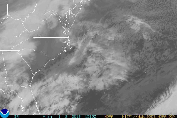
I love when a weather plan comes together. 🙂 That may hug the coast all the way to the Carolinas.
For a while now, we have been noticing the operational models signaling some massive cold blasts into the country in the extended forecast period. These haven’t been showing up as modeled, but many times it’s just the models signaling what they are seeing farther down the road. They sometimes just get overly excited and jump the gun.
It’s interesting to note the CFS is now seeing a much colder (relation to normal) setup taking shape in the coming weeks. Let me preface this by saying it’s a seasonal model that should always be taken with a shovel full of salt. 🙂
Weeks One and Two…
 Weeks Three and Four show the switch to colder…

I started looking deeper into the recent runs of the CFS through October and they are showing a very blocky looking pattern developing. For fun I pulled up the recent WeatherBell CFS snow forecasts for the next 45 days. The latest run…

The run before that…

And the run before that…

Again, this is all for fun in looking at those models, but I have never seen them showing anything like that before Halloween.
Looking into the winter forecast from the same model, we still find the big warm pool of water in the Gulf of Alaska…

That warm water was there in the historic winters of 2013/14 and 2014/15. I said back then, the warm pool was driving the overall winter pattern. Last year it was muted by the Super El Nino. This year we only have a weak La Nina or Neutral signal showing up. Hmmm
Have a great day and take care.

A lot of areas still have not measured a drop of rain this month. The lack of moderation is frustrating. Through the summer it rains seemingly every day. Then Sept through Nov we can’t buy a drop.
My area missed rain during the heavy times. Just missed a lot. Even on precip. models where were in the near average range. But my area was definitely below average. Places not far from here, however, did get average to above-average. The only benefit was that not as much moving was needed. Creeks near my house have been completely dry for a while which does not happen often.
Knoxville is only about three inches below normal for the year. But go the short distance down to Chattanooga (near where my folks live) and they have a deficit of over 13 inches.
That is typical though…Sept and Oct are the two driest months of the year on average. Shoot, we missed all the rain here in Harlin during August with less than 3 inches for the month!!
What’s interesting about Juia is it formed over land..Never heard of that happening before..
I’m not real good at reading weather maps so in layman’s terms what does that say for Northern Kentucky?
Snow in October? Yes, please!
I absolutely true doubt that is going to happen
It’s rare, yes. But there is always a chance.
Truly not true
yes it can happen, I remember back in early 90’s we had a white Halloween here in western ,ky. just enough to cover the ground.
We had about 5 inches here in SE KY (in the valley)on that date. I was 10 years old…last year trick or treating in the snow!!!
I know it can happen Halloween 1993, 23 yrs ago. The chances of snow in October is extremely rare in these parts. Much better shot of hitting 90 in October then getting any sort of measurable snow.
I agree. Every year, people harp and harp about getting the biggest snows in April when the reality is that it happens a couple times a century…last one in KY was like April of 1986. I have even argued would people over the years who claim the March super storm of 1993 was in May….never seen measurable snow in May, much less a blizzard
Halloween of 2014 brought snowflakes and high winds to Laurel County while trick or treating. Cold kids in costumes!…could we see more?
With this year’s model trouble, I would think anything is possible next month. It is terrible that even a tropical storm overall path can’t be predicted 24 hours out right now!
I’ve seen it snow in October as a kid growing up in the 90s. It was enough to make the ground white during Halloween. Also watched it snow in October an hour before midnight on Halloween just a couple of years ago. So….people can’t say it doesn’t snow in October cause I’ve seen it happen many times. I just hope the snow holds off a little longer this season. I’m not a huge snow lover as I use to be.
To add…I’ve seen it sleet in September as a kid while I was at the world chicken festival. It was weird, but it did happen. It was also the coldest day in September that I’ve ever experienced.