Good evening, folks. I wanted to drop by for another update on the bitterly cold air and the potential for some winter weather over the next week.
Tonight is not going to be nearly as cold as what we had last night, but a few spots will hit the single digits for lows. Thankfully, winds aren’t a big player.
That changes over the next few days, as a monster winter storm/blizzard rolls up the east coast, with an arctic front moving into Kentucky. This will produce snow from Florida… FLORIDA… To Maine…

As expected, we are now finding the computer models starting to see the snow showers moving in from late Wednesday into Thursday…

That strong northwesterly flow will combine with arctic cold temps to squeeze out lots of snow showers and flurries. Local accumulations will be possible during this time. There could be another snow shower or flurry maker moving in on Friday.
Air temps hit the single digits again by Thursday morning, with zero or below possible by Friday and Saturday mornings. Winds are going to be gusty during this time, creating dangerous wind chills…
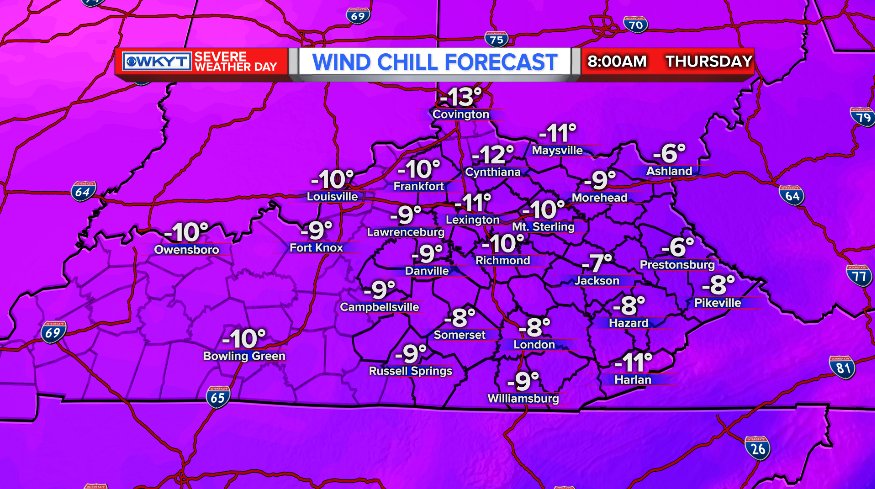
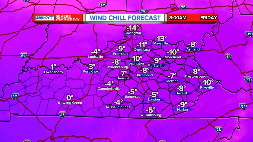
What you see for Friday, is what you’re gonna see on Saturday. The dangerous wind chills are going to be more widespread than what we had this morning. Take precautions now.
The system Sunday into Monday continues to set off alarm bells in my head for the potential for icy conditions. The models are slowly coming in colder, but just cannot fully understand that low-level arctic cold does not get pushed out without a strong system.
Still, the GFS is trending toward more winter weather…

Even if temps do go above freezing, with some rain falling, the ground is frozen and road temps will be crazy cold. I have seen many, many instances of ice developing in this type of a setup.
Another shot of bitter cold comes in behind that, with some snow showers for Tuesday and Wednesday. Another winter weather maker should follow that up a few days later.
I will see you guys later tonight for another update. Enjoy your evening and take care.

Thanks Chris. Boy if that map could just be snow! Oh well. The cold is definitely in play. And my sisters in the “Sunshine State” are getting ready for their own brand of winter weather. What crazy weather. Have a good night everyone and stay warm!
Chris it’s already in the single digits, at 8 pm. I’m thinking tonight may be colder than last night in some spots..
True haha
I do not like the look of the Monday system for far southeastern Kentucky. Cold air has a tendency to get trapped here resulting in major ice problems.
Got an ugly , similar look to the February 2015 storm….the one with only mix/rain forecasted but pummeled Harlan with wet snow/mix then rain at the end of it…you never know when arctic air is in place as it is hard to push strong highs out.
Already 8 degrees at 8:45 in Knox.
Already 6 degrees in wolfe county
Just spoke to my sister in East Texas…snowing there. They have already had a two inch snow this year. Here, in Fleming Co. KY…half-inch. Go figure. Must be global warming.
Global warming causes problems at both extremes.
This is true. No local weather event proves or disproves climate change.
Still touting leftism?