Good evening, folks. A developing winter storm continues to take aim at areas of the bluegrass state. This will bring snow and ice to many tonight, but it’s still a fine line we are walking across the northern half of the state. North of the line is pretty much nothing, south of the line you can get a lot of snow and ice.
I’ve been trying to update the blog for more than an hour, but the server is struggling to handle all the hits today. As Coach Cal says… You people are crazy! But… I love you guys and our awesome weather community we have on here. 🙂
Since I’m having issues updating, this is a bare bones one without all the models I had planned to show. 🙁
We finally have a Winter Storm Warning for far southeastern Kentucky with a Winter Weather Advisory for many other areas…

The Advisory should be a bit farther north in the east and we should have more counties under a warning in the southeast.
A mixture of snow, sleet and freezing rain will roll into these areas later this evening, with the bulk of the winter weather arriving late tonight into Sunday. Given the mixed precipitation types, it makes it difficult to talk specific snow totals. Areas that get more freezing rain will obviously come in on the low end of the snow totals. On the flip side, those who get less freezing rain will have quite a bit more snow on the ground.
As mentioned, it’s a VERY fine line between no precipitation and the band of moderate to heavy wintry precipitation. These lines are not the end all be all of where this thing winds up, as everything could shift a little farther north or south. Here’s my updated call…
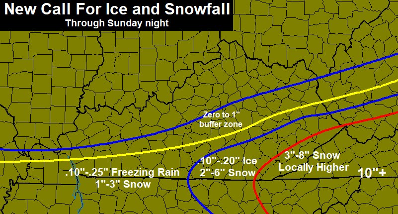
I will get a final call out later this evening as I get a better handle on just how far north this may or may not get.
I will throw you another update later.. If I can log in to do so. You guys are crazy. 🙂
Here’s regional radar to tide you over…

Have a great evening and take care.

Thanks so much! I sure appreciate all you do!!
Thanks Chris. We promise we will try to be good so you can update…. . Thanks for all your hard work for us. We know you love it as much as we do! By the way had to run to Kroger to get something and you’d have thought it was a grand opening! Had to park all the way out to the outer parking lane! But they did still have milk and bread! They were out of turkeys for 29 cents a pound!
Thanks Chris… Sure hope that Pikeville stays in the heavy area. Missed out on the couple storms around last winter.
We are right on the fence it seems, gonna be interesting too see how it plays out here in the Pikeville area.
We wuv our Weatherman !
Ditto! Agree totally.
Chris + snow potential = broken internet Good problem to have, I guess!
Any chance this can go North enough to reach Hopkins County KY(Madisonville)?
I’m really hoping it treads a little more north, I’m not one for snow but I actually want to see some. Oh and with this site being down and NWS being down as well, it’s been hectic to say the least
What a headache this storm has been for mets. I literally lol’d at the afternoon discussion from Jackson as they were describing how crazy the models have been the last few days.. Looking forward to tomorrow to put it to bed finally.
Rolo, where are you? I’d love to hear some thoughts on the radar!
we might see some thunder snow in se ky, jkl has some decisions to make
Go north! Go north!!
Thanks Chris for your dedication, I’m quietly in the corner watching all the updates!! Cold & calm in the Belfry area.
Snow being reported in Middlesboro
Yes. Light snow and freezing rain.
Winter Storm Warning for parts of southwest KY now…sounds like more of an ice threat there.
Wish Ashland Huntington area got in on this. Maybe Next time!
Enjoy your snow, snow lovers!
radarscope showing the freezing rain turning to snow in se ky, i cant confirm because its not here yet
Sleet in knox
Can’t be freezing rain…since the Bell County airport reports 36 degrees. Might be sleet or ice pellets?
snowing in Harlan
Hopkinsville in western Kentucky forecast of 0.2 – 0.4″ ice. Yikes!