Good late Saturday evening, folks. I’m dropping by for a quick update on our winter storm that is trending father north compared to earlier runs. Sleet, freezing rain and heavy snow are in the works for a pretty big chunk of real estate across the bluegrass state.
Winter Weather Advisories and Winter Storm Warnings are up for many areas…

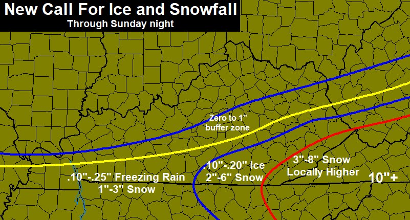
Significant amounts of freezing rain are very possible in some of the counties across the south and south central. That’s before some of these areas go over to snow. Power hits are possible in some of these areas.
Given the sleet and freezing rain issues, the snow forecast is a tough one. Obviously, areas seeing more freezing rain will get much less snow. That said, for those areas getting more snow… look out. A heavy, wet snowstorm is likely in those spots and that could also cause some tree and power issues. This will NOT work out perfectly because of the mixing issues, but it’s what I’ve got to show…
I do want to take a quick look at a few models that are throwing some big numbers out there for both snow and ice.
NAM Snowfall

NAM Freezing rain forecast 
Hi Res NAM snowfall forecast

Hi Res NAM freezing rain forecast

Here are some tracking tools…

Fort Campbell

Kentucky/Tennessee border on I-65

Bowling Green


Pine Mountain

Jenkins

Mountain Parkway near Slade

Richmond

South Lexington

Morehead

I will update later. Take care.

Chris you have 0 to 1 for Morgan co and Chris Johnson had 1 to 3 which one is it
Starting to get icy in Monticello
Sleeting heavy in Harlan County.
My in-laws in Bowling Green are reporting a little freezing rain.
So far, Nashville is all rain with temperatures just above freezing. Nashville is expected to be about on the southern fringe of winter precipitation.
Boo! Some the heaviest precip entering Harlan but mostly rain with just a bit of sleet now. I had the cars barely covered with snow before the wicked turn. 33 so barely above freezing rain….SUPER, SUPER COLD RAIN. The longer this last, the worse it will cut the totals☹
Temperature has risen 3° with heavy rain for the past hour and a half. This will drastically cut down totals here and unless the temp heads back down soon here in Middlesboro, this won’t be a happy ending for snow lovers…I’ve seen this scenario play out like this numerous times before and the rain always wins
I guess one positive is that the precip is regular rain. Very cold, but slightly above freezing helps. GFS was wrong on the amount of moisture, but unfortunately, the model appears correct on the atmosphere. I hope it changes over soon.
It’s early December, folks. No need to get upset over a winter that has not officially started yet.
raining in harlan at the moment
Heavy sleet for the past hour.