Good Friday, folks. It’s a windy and wet day as low pressure works right on top of the region. As this low weakens and another low strengthens to our east, colder air comes into play tonight and Saturday. That will lead us to some snow showers and even a few periods of light snow.
Let’s begin with today’s rain. It’s heavy this morning across central and eastern Kentucky, but more showery across the west…

Temps in the east may spike into the low 50s for a time today as the west chills into the upper 30s later in the afternoon.
After a small break in the precipitation this afternoon and early evening, more showers quickly return. Later tonight, it gets cold enough for a few rain and snow showers. That’s a trend taking us into Saturday, but we will be watching for a band of light snow to sweep across the northern half of the state by evening. Some very light accumulations will be possible through Sunday, but this really isn’t a big deal.
Hi Res NAM
 NAM
NAM
 It’s been amazing to watch the GFS totally miss the snowstorm to our west and northwest.
There’s another system working across the state with a quick hitting band of rain and some snow Sunday night into Monday…
 I will have updates later today, so check back. Make it a great Friday and take care.

Looks like Illinois Mike may get a decent hit after all as NWS changed his forecast to 6 inches + with an Advisory. GFS looks to be losing this one so far.
Right, Terry. It’s a drizzly, foggy 35 degrees here this morning, but the snow is on the way from early tonight through tomorrow afternoon.
A Winter Weather Advisory is in effect for the entire Chicago Metro Area from tonight through Saturday. A general 3 to 6 inches of snow is being forecast, with the heaviest amounts coming overnight and away from Lake Michigan. The NWS is even saying there could be localized amounts of over 6 inches.
The temp is going to be right around 32 degrees for the snow, so it’s going to be a heavy, wet snow. Our biggest snowfall for the season to date… yay!
We only got an inch of snow yesterday (but I know that would make everyone in Kentucky pretty happy if you guys were to get that much!).
As Bobt had mentioned yesterday about the fence predicted by Bailey, and if this pattern stays very zonal while the southern jet gets active going into February, Northern KY will end up with the best chance for any snow (especially Covington area) while us southern KY folks will be sitting on the sidelines in rain coats with wet faces from either tears or cold rain drops or both looking enviously towards the north, LOL. Even with as poor a chance for snow as this weekend setup is, one can already see the temperature gradient with over 10 degrees warmer shown down here in my area compared to say Bus Haynes in southern Ohio with the EURO showing better chance for snow up his way and all cold rain down here. I hate zonal patterns in winter.
Well Terry, I don’t know what to tell you. Seriously, I thought we would have more Winter weather this year. Not the case, but I’m glad your Palm trees are doing well. Enjoy reading all your meteorological comments and also Jimbo’s comments. Glad the Coffeelady is feeling better and I am looking forward to reading her positive post. Prayers to all and may God Bless.
That’s normal for Fencetucky 🙂 Even the maps show clear bias against us 😉
Least snowiest winter I can recall in East Tennessee in over 23 years, And models aren’t really showing anything through November. If we don’t get some in next 30 days chances are slim we will see any this year. But that’s ok by me!!
Depressing to say the least.
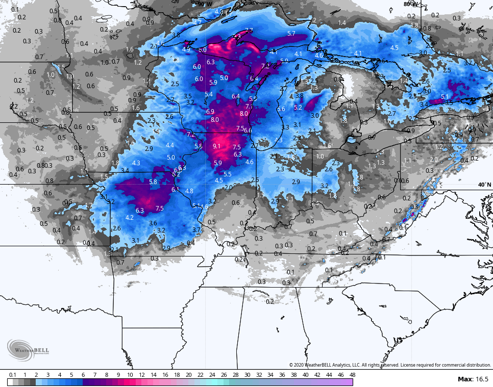
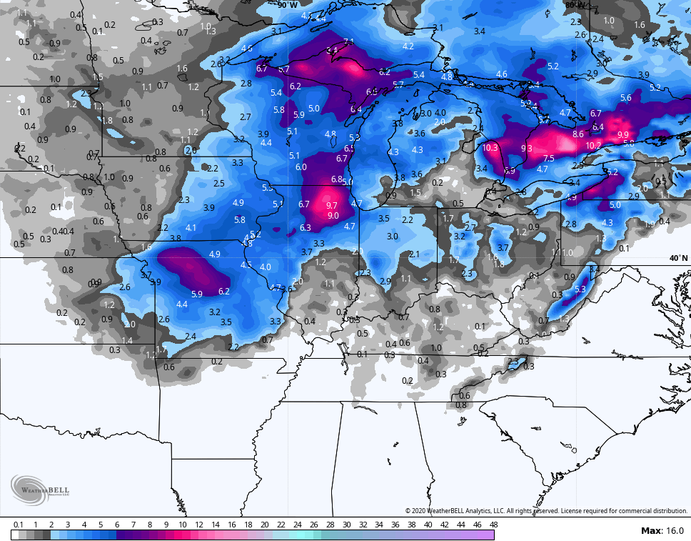
Ok, I said I was going to do this. I took CB’s persistent comments about how far off the GFS was with its westward biased placement along with snow totals and went with the maps he posted with the 0z 22nd runs of the GFS, Euro, Canadian, and NAM through Saturday morning.
So far, after just 2 random selections, Kansas City and Davenport IA, the GFS did underperform with snow totals. However, the other models overshot in terms of totals so that the difference of over and under nearly favors the GFS.
Of course, I have several locations to look at in Illinois, Missouri, Iowa, Wisconsin, Michigan. But so far, the other models were very aggressive with snow totals and NWS forecasts currently are not supporting the amounts. Could be a win for GFS? We’ll find out tomorrow.
You must be really bored
Yes I am.
Believe the first time this winter I’ve seen the euro spit out a system..It’s gonna happen..Just a little NW shift..Terry and all the gang from the southeast gonna get buried………………….With Rain…………
https://www.pivotalweather.com/model.php?m=ecmwf_full&p=sn10_acc&rh=2020012400&fh=240&r=us_ov&dpdt=&mc=