Good afternoon, everyone. A few showers continue to show up across central and eastern Kentucky, but it’s full steam ahead toward a little touch of spring temps for the next few days. That kicks off a very active pattern that has a shot at also giving us a little winter weather.
Temps continue to run in the 40s for much of the area this afternoon as our system dives in from the northwest. A few showers will continue to be around into the evening hours for some…

Sunday continues to look amazing with skies becoming mostly sunny with highs approaching 60. Monday will still see temps in the 60s as we wait for our wet pattern to kick in. Several waves of low pressure work toward the region and could spit out quite a bit of rain. There’s also the chance for some winter weather later in the week as the cold air bullies its way in.
Here’s how the GFS is seeing this…

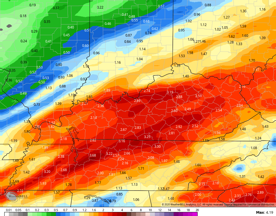
Some pretty hefty rain numbers continue to show up…
 The Canadian Model keeps showing a little more of a winter threat…
 The European Model…
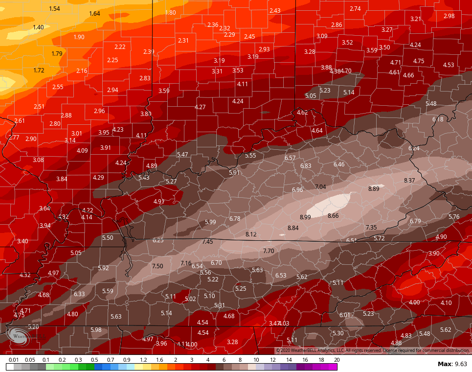
 That would be quite a bit of rain falling and my fear is, this is a pattern locking in for February. If we expand the GFS rainfall forecast out to the next two weeks, the latest run is showing this…
 In the overall scheme of things, I’m not sure I have ever seen a more consistent long term pattern than the one we have been in for the past few years. It’s really uncanny when you think about it.
Enjoy the rest of your day and take care.

Like i said RIP winter blasted by the rain train.
I know some have attacked you before when posting the RIP winter, especially early on in the season, but they have no snow to stand on, LOL. 😛
Good one, Terry! 😀
I tell ya what-I’m almost in the same cemetery as Russell, about to hand out Last Rites. It’s been a very disheartening Winter(so far). I know some have said last winter was bad, too, but I at least got underneath some rogue snow showers that put down a few inches before it was all gone within the next hour or so. Seems like a deformation band is my best buddy the past couple yrs IF one chooses to set up right on top of Bardstown.
My luck this year came with the pretty wet snow (small event) in early December. I only had 2 and 1/4 inches but the high mts received up to 6 inches, and this is better than over 80 % of you all on here have seen (sad I know). 🙁
Other than that, I had almost an inch on Veteran’s Day night and almost nothing since down here with a whopping 3.62 inches on this dismal season, so far.
Running out of winter. CB is right, hard to believe that are winter’s have turned into a rain fest. At times I kind of missed Bubba’s below 32 and dry days. We rarely go below 32 now days.
We have had many lows above 32 let alone very few subfreezing highs. We have had multiple stretches of over 10 days this winter in Harlan without a single frost. I saw a Quince and a Forsythia bush both with some flowers a few miles from my house at 2:00 PM today. Crazy, but it was the same last year as most trees bloomed in March and they will bud up fast with those mild days and nights coming.
I’m not saying it will as the sun spots goes smaller in it’s peak this year and next year this pattern may change. CB is right the pattern were in has been going on too long
Eventually the dam is going to break. When it does, it will be disastrous.
I’d also like to file a motion to have Lexington, Kentucky nicknamed “The Seattle of the East” since we have been in a period of at least 125% normal rainfall for the past four years in a row, many of these coming over and over again in the past twenty years. Sparing September 2019, we seem to get rain every two days.
A rarity too is no snow days this year for LEX schools. That hasn’t happened in a long time. I am starting to see a lot of regional schools closing for sickness, though…
This new climate is not my favorite to live in. You are right about the every other day rain. I miss the summers that had stretches of hot weather and sunshine. If you get a three day stretch of dry weather it’s rare. I looked up some stats on 2018 a while back and we had something like 20 more days of rain than what the average was for the wettest place in America.
Hoping to see a strong La Niña in the future..Supposedly strong La Niña are hot and dry but who knows in this ever changing climate.
I thought 2011 was a strong La Nina when we had a strong severe weather season but overall wet year? I may be wrong on that and need to look it up. Snowfall was abundant only in December 2010 and early January that year, then quite a bit of severe weather with much above average temps until summer which was very wet through fall and kinda cool.
Yes, late 2010 into early 2011 was a strong La Nina with the early snows (2010 White Christmas for Bowling Green, Nashville…, then in January the 18 inch snow along the TN-AL line). This was followed by the very abundant severe weather including the historic April 27 2011 tornadoes across Alabama, Georgia, Tennessee, Virginia.
Late 2011 into 2012 was also a La Nina (March 2 2012 tornadoes including West Liberty KY, Crittenden KY and Henryville IN).
But as has been pointed out before (including by Chris Bailey), no two La Ninas are alike and no two El Ninos are alike.
I agree and think other factors like the Southeast Ridge have had more dominance in our more recent, poor winters than whether or not we have had in place a strong/weak La Nina or El Nino or just neutral.
Winter isn’t over. We can get hammered end of Feb and March.
The only hammering I’m going to be doing is hammering nail to wood so I can build a boat to row out of here…..
Memphis TN of all places has had its top two single storm snowfalls in the month of March! The number one snow was back in the 1890s (forgot the exact year) with about 18 inches (Nashville TN was nailed by the same storm giving Nashville its biggest single snow). Number two snow in Memphis was March of 1968 with IIRC about 15 inches.
I was nine in Morristown TN when the Blizzard of March 1993 absolutely buried Morristown, Knoxville, Chattanooga, east Kentucky, even central Alabama (Birmingham about 14 inches).
Not necessarily saying big snows will happen later this season, but history tells us not to ignore March!
Winter isn’t over, but we just made it through 2/3 of it with most of the state with nothing more than a dusting of snow. I know it snows in February (although the first half isn’t looking promising), but if you are banking on a great winter when you are starting on Feb. 15 then I think most people will be disappointed. Here today gone tomorrow snow is what you will get in mid-February and beyond.
TRUTH!
About the longest lasting and of course the largest snowfall in March in my lifetime was the March 93 Superstorm. The only reason it lasted a whole week was the few days of arctic cold behind the storm which prevented no melting but then it went pretty fast after the 4th day:
https://www.weather.gov/ilm/Superstorm93
We had a decent snow a few years ago in March 3-5 inches I think, and it was gone the next day. It had rained so much the days prior that there was standing water under the snow. It was a mess to get out in. Since we have not had single night under 15 degrees this winter I doubt a repeat of 1993 is going to happen.
Good thing the Super Bowl isn’t today, as south Florida has been getting rain. There were t-storms earlier today with a low tier severe threat, but the roughest weather has moved on. Tomorrow will be much better in Miami if a bit cool by their standards.
Miami got about an inch of rain back in 2007 when in that Super Bowl the Colts defeated the Bears.
Speaking of severe weather, Kentucky will have its 2020 Severe Weather Awareness Week this March 1-7. Tennessee’s Severe Weather/Flood Awareness Week is set for later this month February 23-29. Tornado drill days for both states are yet to be determined.
LOL, back end mist of moisture’s gone snow scrap threat. Coating alert 😉
Mist, most. Same result 🙂
With those temps next week, I think your coating alert could even be over zealous 😛
I mentioned weeks ago how wild it would be to have THREE Februarys consecutively with a foot of rain in Harlan. Well….I may see that! I still can’t get over having two years straight with more than 12 inches of rain in the same month, let alone if this becomes three since the February monthly average is barely 4 inches. 🙂
Sounds like we better get use to it.
Um…on the local news tonight, one of the mets mentioned an Alberta clipper possibility next Sunday. Interesting but I don’t see how it can happen. It’s supposed to be near 70 on Monday and stay slightly warm until Thursday with a lot of rain. Maybe I am missing something?
Maybe in Alberta 😉