Good Saturday, everyone. We have another round of light snow rolling across the state today, bringing some minor accumulations. As we look ahead to next week, we find this active pattern persisting with more rain AND snow chances showing up.
Let’s begin with the light snow of today. Accumulations range from a coating up to 1″ of snow for a few areas. There’s an outside chance for a locally higher amount, but this isn’t anything like what we had Thursday night.
Here’s the Winter Weather Advisory to start the day…

I will have your tracking toys in a bit.
Sunday looks much better as temps warm to near 50 in the south and 40s elsewhere. Clouds will increase with showers moving in late in the afternoon and evening. That sets the stage for some wet weather for Monday…
 The potential for heavy rainfall is there and the heaviest may fall in the area we do not want to see it in… the southeast…
 That same front sets up just to our south and may allow additional waves of low pressure along it. This could lead to more heavy rain and some winter weather…
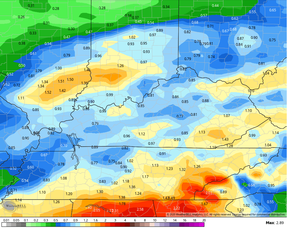
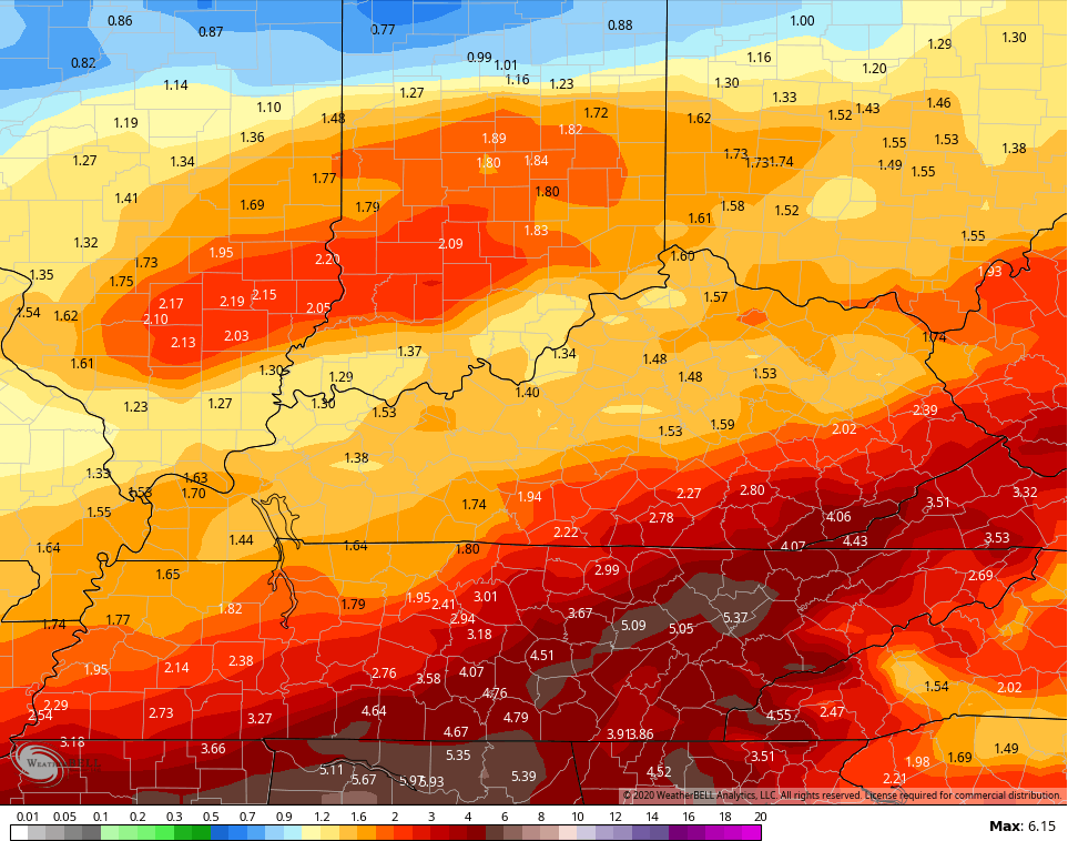
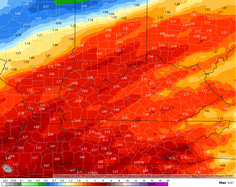
 Total rainfall numbers through next Friday are concerning…
Canadian
 Euro
Euro
 Ugh!
Ugh!
I will have updates later today. Until then, here are your early Saturday light snow trackers…

Louisville


Lexington


Covington area


Florence

Georgetown

Frankfort

E-town


Morehead

Winchester

Maysville

Mt. Vernon

London

Corbin

Mountain Parkway near Slade

Pikeville

Make it a good one and take care.

The ICON run came in with 5 to 7 inches around Harlan county, SW VA, far SE KY and especially East TN just through Friday (RAINFALL). The EURO is the lightest of all models but still over 2 inches. Incredible but scary at the same time! I have 6 inches of rainfall on the month, so I could be near or exceed double digits by just the 14th….that would be impressive for snow but this is rain people.
Is that “additional rainfall” Terry to what we already have received? If that is accurate, destruction will occur my friend. No question about it. :'( Usually the EURO is the most accurate. Still not good. The NWS Charleston has 1-2 inches for my local area Monday alone, which indicates that the ICON (I never heard of it until I just read it now) may be right this now. Not good again, for southeastern KY or southern WV (my local area). Plus some unexpected snow flurries may hit my county again…
Yeah, that will be new rainfall Monday through Friday. Thankfully (not for the Deep South obviously) the worst should stay south of us but still a lot of rain. Plus, you always got to watch those NW trends that could put us in the higher totals yet.
Not all that comforting knowing all that water on the Cumberland River has to go downriver including through here in Nashville 🙁 .
I am sorry TennMark, about sending those Harlan Co ducks your way. 😛
this time I meant to say.
On this day in history back in 1994 was the start of the ice storm that crippled parts of KY, TN, AL, MS including Bowling Green, Nashville, Memphis. My future wife experienced this event growing up in Bowling Green; little wonder that she and others that otherwise love winter detest freezing rain. Areas of rural northern Mississippi did not get their power restored for almost a month.
Although the anniversary was a couple of days ago, many here recall Feb 5 2008 was the so-called Super Tuesday tornadoes in KY, TN, AL, AR. This unusually strong winter outbreak for so relatively far north included many EF3s and even several EF4s.
https://en.wikipedia.org/wiki/2008_Super_Tuesday_tornado_outbreak
Speaking of severe weather, the Storm Prediction Center has been making some nice updates of their website. A little over a week ago, the SPC started issuing individual hazard probability graphics for tornado, severe wind, and severe hail on their Day 2 Convective Outlook. This was previously available only on their Day 1 Convective Outlook.
Pick up a couple more inches of snow today here in Southern Ohio.
Total for the year now around 10 inches.
Lucky dog! 😛
I hope I get my biggest yet before spring really sets in.
Terry I guess we were in the right spot today.
Very pretty. We all might get a big wet snow before its all over with this winter.
I think so! Obviously, only God knows for sure but I still refuse to call this the worst winter ever, and we are all starting to get more than last winter in most areas anyways.
We have gotten over 4 inches in the last two days. We use to get almost that much in one Alberta Clipper years ago. And we use to get a lot of them here where I live in one winter.
Yeah it is a crappy winter still, but I hope maybe for a little redemption. We certainly can’t call this a harsh or cold winter, even if we get a big snow at the end.
I NEED SNOW/ICE/SOMETHING, or my sneezing is going to blow KY clear off the face of the Earth!!! 🙁
Crazy little wreck on the Covington camera right now.
Nature of the beast in Cincy though.