Good afternoon, everyone. Torrential rains are moving into the region and will continue into the overnight hours. Flooding and flash flooding issues will develop and things could get rather ugly in some areas. We are also on guard for a few strong storms in the southeast.
A general 1″-3″ of rain will fall through tonight across many areas, with the greatest concentration across central and eastern Kentucky. The Weather Prediction Center has a Moderate Risk for flooding out for these areas…
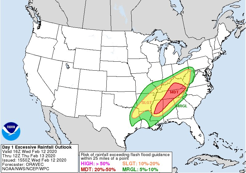 Flash flooding and general flooding are likely with this setup, so please stay alert to this potential into early Thursday.
A few strong storms may show up, especially across southeastern Kentucky. This is where we have a low-end risk for severe storms from the Storm Prediction Center…

I will have the latest on WKYT-TV starting at 4pm and will try to have a KWC update this evening, but I may be a little busy. Regardless, I have you all set to do some tracking…


Current watches

Possible Watch Areas

Enjoy the day and take care.

CB, just say Rain, and drop the mic.
CB could just automate the the date and maps and keep the same forecast pretty much all year. Headline could be “It’s going to rain 5-6 days this week”. Pretty much nail it for most of the year.
Yeah, All you would have to do is adjust the temps from time to time. I have had nothing but rain for going on 3 years. But last September I only received a trace of rain. I still don’t know what happened that month.
RIP winter its the rain train forever
Dare I say the forecasters jobs have been too EASY this year?
*evil laugh*
We should not forget how quickly things can change in the world of weather, lest we be caught sleeping when things change in the blink of an eye.
Lol. I’m just saying it would be less trouble to copy and paste the same statement about it going to rain. Link AccuWeather for the temp and maps. Wouldn’t have to make a post saying otherwise more than once or twice a week. CB could free up all kinds of time
Warmed up to the 60s feels pretty nice out atm
On the radar the rain seems to be staying west of Thursday’s hardest hit areas in the southeast part of the state. Will this trend continue or will we get the predicted rainfall in this area?