Good Sunday, my weather peeps. After stubborn clouds ambushed my Saturday forecast, it’s time to look ahead toward more active weather. That active weather finds the return of rain later today, with the potential for strong to severe storms in the week ahead.
Temps today do recover from what we had Saturday, but clouds are going to continue to be an issue. A little sun can show up before the rain arrives from west to east this afternoon and evening. Some folks may even hear a rumble of thunder.
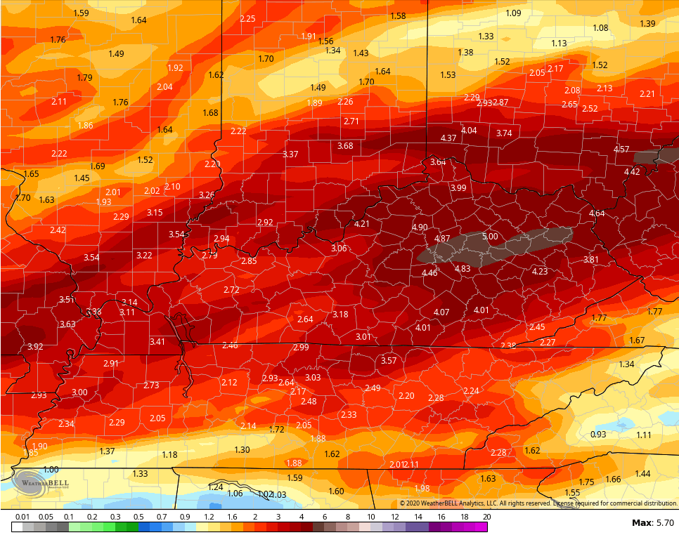
We will have to watch areas of southern and southeastern Kentucky. This area has had a ton of rain of late, so it won’t take much to cause local high water issues.
This rain moves away by Monday afternoon as skies brighten from west to east. This is ahead of a more potent system working from west to east Tuesday and Tuesday night. Heavy rain and severe storms are possible with this feature. The Storm Prediction Center has the region in a sever weather risk…

Temps spike deep into the 70s for the second half of the week as we watch a few more storms fire up. That may lead us into another strong to severe storms threat by the weekend.
The GFS rainfall forecast over the next 7 days shows the active pattern…
 I will have another update later today. Until then, here are your Sunday tracking toys…


Have a great day and take care.

Thanks, CB! Can’t get much of a break from the flooding rain 🙁 .
The SPC’s Forecast Discussion for Tuesday has damaging winds as the main “convective” threat, but with some large hail and some tornadoes. Still a couple of days to tweak this forecast.
Ohio’s Severe Weather Awareness Week is March 22-28 which includes a tornado drill on Wednesday March 25. But any adverse weather could postpone this drill.
https://www.weather.gov/cle/SevereWeatherAwarenessWeek
With strong storms a possibility on Tuesday evening…its good to
look back at some famous severe weather with famous tornadic
anniversaries…
Mon…3/23/1913…F4 hit Omaha killing 94 & F4 hit Terre Haute IN
Tue…3/24/1975…F3 hit GA Governors mansion killing 3
Wed…3/25/1901…F3 hit Birmingham at 945 am killing 15
Thu…3/26/1948…F4 destroyed 85% of Coatesville IN
Fri…3/27/1890…F4 hit downtown Louisville killing 76
Sat…3/28/1988…Supercell hit OKC…with up to grapefruit size
hail…my car was hit by golf ball size hail for nearly 20 minutes.
That’s for you TennMark one of the NWS employees in Louisville shared this in forecast discussion this morning.
1 to 2 inches of wet snow is predicted for the Chicago area later this afternoon into tonight, mainly on gra*s*s*y areas. This will add to our meager total of 22 inches at the NWS forecast office in Romeoville for the season.
It’s certainly cold enough, with temps ranging from 32-34 degrees throughout Chicagoland, and not expecting to get any higher with the cloud cover.
Could this be our last measurable snow of the season… that remains to be seen, as we had a couple of measurable late-season snows in April last year, which were very unusual.
Rejoice! LOL! That’s 20″ more than I’ve seen since our toe-tingler back in early Nov. 🙂
Haha, isn’t that the truth… even though we here in the Chicago area have received much-below normal snowfall this season, it’s still 3 to 10 times more snow than what Kentucky and Tennessee have received!
As I’m typing this, there’s a steady snow falling outside here in the SW suburbs of Chicago, and I’m going to go out for a power walk in the forest preserve near me to enjoy it!
Have a good afternoon all and stay safe!
rain and storms than more rain? you don’t say….. I sure hope this summer isn’t a soaker. eastern KY could use a lot more sun and little less rain. quite depressing. with this crisis, I hope you guys stay safe out there.