Good Saturday to one and all. We have another windy and warm day across Kentucky, but the focus is on the potential for strong to severe storms tonight. This is part of a significant severe weather outbreak from the Mississippi Valley into parts of the Ohio Valley.
Temps today will be back into the upper 70s to low 80s with a mix of sun and clouds. Winds will be gusty ahead of the storm deepening to our west. A line of strong to severe storms will develop and work from west to east later this evening into the wee hours of Sunday morning.
Here’s the current Severe Weather Outlook from the Storm Prediction Center…

Damaging winds are the main threat with this line of storms, but large hail and a tornado will be possible.
Gusty winds will blow in here for Sunday and may reach 40mph at times. Skies become mostly sunny with temps in the upper 60s to around 70.
Clouds will filter in on Monday ahead of our next system. This looks to bring some ugly in here to end March and kickoff April…
 Temps on Tuesday may not get out of the 40s.
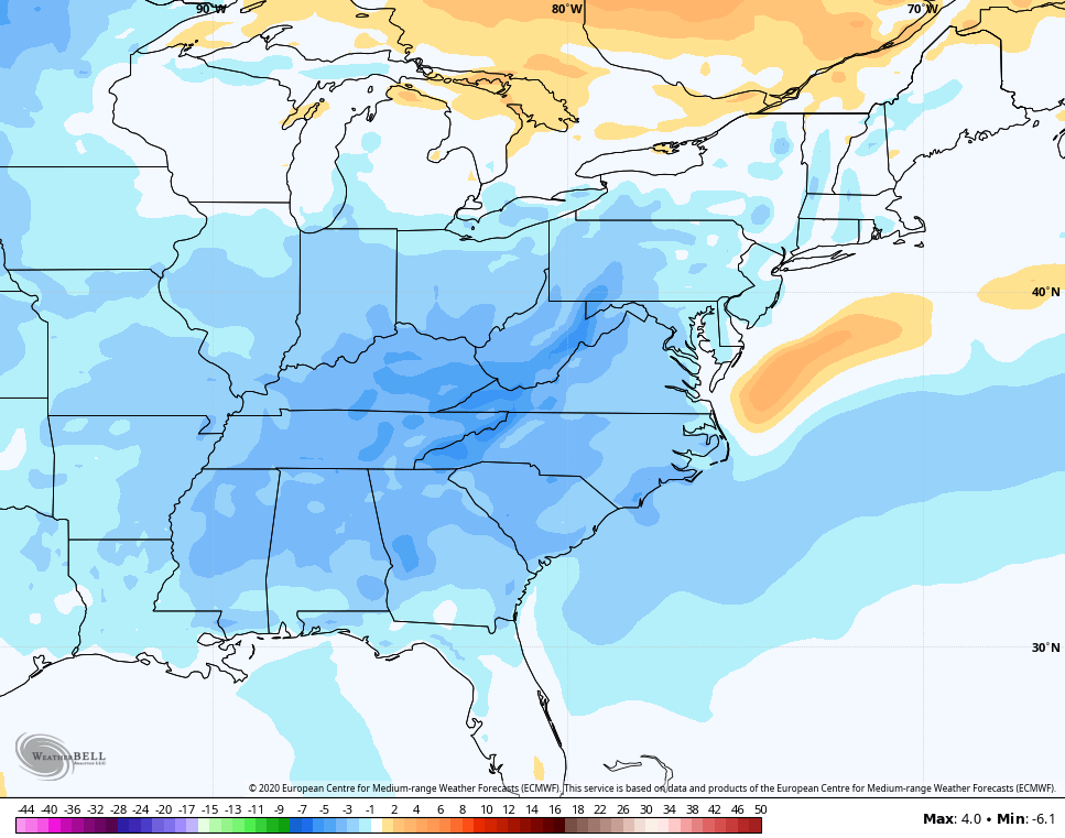
Temps will bounce back after that, but the signal for cooler than normal temps continue to show up for early April. The Euro Ensembles show the first 10 days averaging colder than normal for much of the region…
 I will have another update later today. Until then, here are your tracking tools to take you through the rest of the day…


Current watches

Possible Watch Areas

Have a great day and take care.

There’s going to be a major severe weather outbreak across Northern IL and the Chicago area later today, as the SPC has a large part of the Chicago Metro area, including the SW suburbs where I am, under a moderate risk for severe weather, a threat level we haven’t seen here in a couple of years. The SPC says they will even consider putting the area under a high risk of severe weather later today!
This is just six days after our largest snowfall of the season, over 5 inches in the SW suburbs!
It’s crazy how wild a month that March can be weatherwise!
Stay safe Mike.
Thanks, I appreciate it. The main threat appears to be late this afternoon into this evening, as a warm front approaches the area.
It’s a chilly 49 degrees now as a general area of showers is approaching.
75 degrees here in central Kentucky with very high dew points for this time of the year. As the cold front approaches later I would expect some areas to see severe weather especially west of I- 65.