Good Monday, everyone. We have a slow-moving low spinning across the region for the next few days and this is likely to cause issues. Repeat showers and thunderstorms will likely lead to flooding and flash flooding issues developing and a few of the storms may be strong or severe.
Let’s kick things off by looking at the Flash Flood Watch current in effect…

As mentioned, rounds of showers and thunderstorms will be spinning counterclockwise around our slow-moving low pressure. That means the same areas may be hit by repeat storms and torrential rains. That could cause flash flooding and general flooding through Tuesday or early Wednesday.
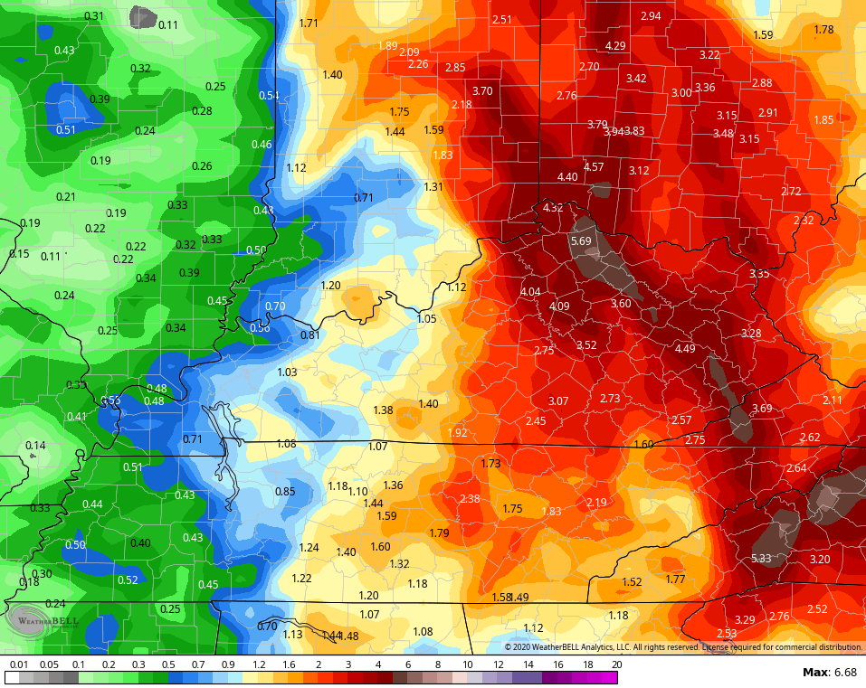
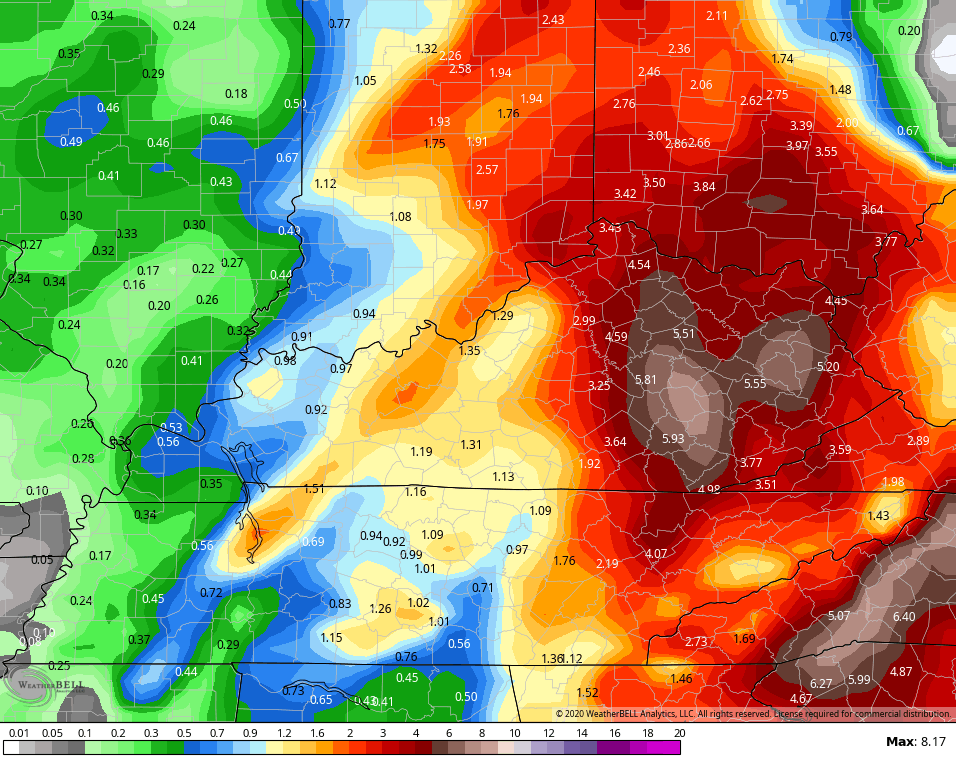
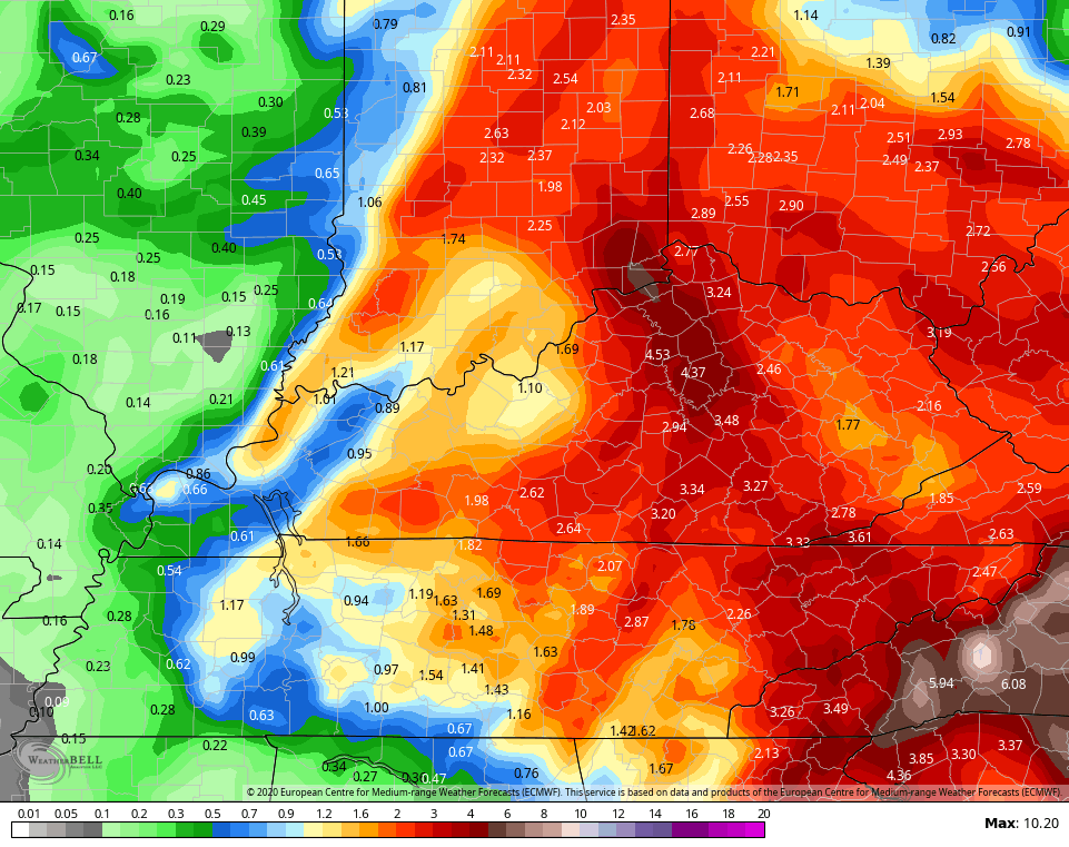
A corridor of several inches of rain is likely to set up somewhere in this region…
GFS
 CANADIAN
 EURO
EURO
 In addition to the flash flood potential, some of the storms out there today into tonight could be strong or severe. The greatest risk is across the eastern half of the state. Here’s today’s Severe Weather Outlook from the Storm Prediction Center…

I will have updates as needed today and will have the latest on WKYT-TV starting at 4pm. Until then, here are your tracking toys for the day…


Current watches

Possible Watch Areas

Have a great Monday and take care.

Prolific rain totals across the Chicago area on Sunday… 3.11 inches at O’Hare Airport (shattering the previous record for the day of 1.38 inches), 3.64 inches at Midway Airport, and 2.64 inches at the NWS forecast office in the SW suburbs. Some areas got as much as 5 inches. Many roads are closed to due high-water issues, and area rivers are above flood stage.
Since Thursday, 7.88 inches of rain has fallen at O’Hare Airport, which brings the May total to 8.19 inches. The rainfall record for May is 8.25 inches, set just last year. We’ll obviously smash that record, with two weeks left to go in the month. Pretty crazy!
I’ll watch with interest to see if Central and Eastern Kentucky will get as heavy a rainfall through Tuesday as the Chicago area did on Sunday.
Wow Mike, That is a “hell of a lot of rain” I think you have had more rain this spring than we have had here this entire year in just one week.
The upper level low that will be responsible for the predicted heavy rains and storms shows up real well on the twelve hour Water Vapor Loop :
http://mp1.met.psu.edu/~fxg1/SAT_US/animwv.html
Tropical Storm Arthur maybe causing a “block” in the Atlantic and keeping the Upper Level Low in our area through the week ? The 2020 list of names were posted this morning for the Hurricanes and Tropical Storms , which is predicted to be a very active season of storms in the Gulf and the Atlantic.
About two hours ago we had a very heavy rain shower blow through Taylor County. A brief bout of wind from the northwest. Heard thunder, but no cloud to ground lightning. Some rotation was noticed. This is an active line of storms be safe out there folks.
Heavy rain moving into Taylor County once again from the southwest to northeast. Dry line noted to the west of Bowling Green on the water vapor loop. This line is just ahead of the much advertised upper level low pressure system that is moving into our area. Take care folks.
The FF Warning for Fayette county looks like areas from downtown and points east getting in on the worst. BG airport and even the Mesonet site not showing impressive rainfall totals yet. It will be interesting to hear from Bailey how much rainfall he got at his place later, since it appears that part of the county is getting rocked.
Here is a complete summary of Sunday’s major flash flooding across the Chicago area… http://weather.gov/lot/17may2020
To put things in perspective about how historic the rain numbers were… two of the five wettest days ever recorded during any May in Chicago have happened in the past week, and last Thursday’s 3.53 inches of rain at O’Hare Airport broke Chicago’s record for the wettest calendar day ever in May!