Good Friday, folks. May is just about out of days and a cold front is sweeping in to bring some changes to end the month. These changes are being ushered in by showers and a few strong storms out there today. Once the front moves out, we get a blast of awesome weather for the weekend and into early June.
Today’s showers and storms are scattered early, but may come together into more of a line this afternoon and evening. There’s still a low end threat for a strong or severe storm going up. Here’s the current Severe Weather Outlook from the Storm Prediction Center…

This action sweeps through pretty quickly this evening, then it’s game on toward some fantastic weather. Saturday highs are in the 70-75 degree range for many with a mix of sun and clouds. That sets the stage for lows in the 40s by Sunday morning across central and eastern Kentucky…

Highs on Sunday may not make it above 70 in some areas. Lows by Monday morning may flirt with a record or two for the first day of June…
Temps are back to around 70 in the east and upper 70s west.
Temps begin to warm on Tuesday and most of us are deep into the 80s Wednesday. That will be ahead of a weak front dropping in from the north. That boundary may make it into Kentucky then slow down as a big heat ridge builds into the plains and Mississippi Valley. The Euro wants to put our region on the cusp of the real deal heat late next week into the following weekend. That could put us in the ring of fire for big thunderstorm complexes dropping in from the northwest…
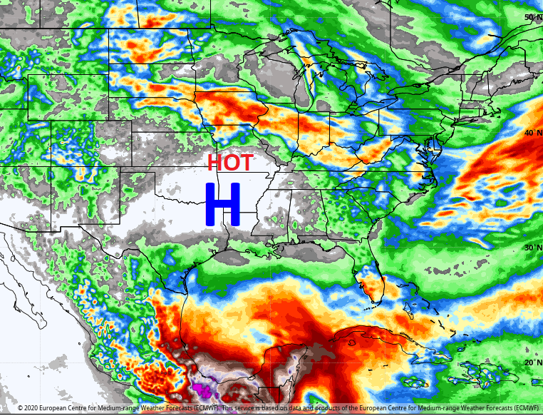
Check out the heat the EURO is bringing toward us during this time…

Ouch!!
Once again, I leave you with your storm tracking toys for the day…


Current watches

Possible Watch Areas

Have a fantastic Friday and take care.

Thanks Chris, The cooler weekend Temperatures will be most welcome to me and my air conditioning units.
Thank you Chris. Sounds like a good weekend to ride around worth the sunroof open. Or maybe a short road trip! Either sounds good! I would not mind it being a bit warmer though for the pool. But the solar cover has helped a lot with that. Looks like mother nature’s a/c will be used at least for afewdays. Have a great Friday everyone and get out in your yard if nothing else and enjoy this weather!
Yeah, that temperature map looks like two maps showing exactly the same thing, a digital carbon copy. Might want to fix that…unless you were just wanting to emphasize how refreshingly cool it will be, which is ok by me.
I’m glad I can view this site again without getting that unsafe malware possibility page