Good Monday, folks. We have a couple of very nice summer days taking shape across the area to start the week. By Wednesday, we are back into a pattern where heat and humidity ramp up, but rounds of thunderstorms are going to try to help us out a bit.
Let’s kick things off with today before looking ahead. It’s another pretty comfy summer day with highs mainly in the low to middle 80s under a partly sunny sky. That said, there’s still a slight chance for a stray shower or storm in the east early on…

Overall, this is a great day to get outside and enjoy it and that’s what your friendly weatherdude will be doing.
Tuesday is a little warmer, but still pretty nice.
We start to feel the steamy changes on Wednesday as temps begin to ramp up. There’s a big heat ridge making a run at us for the end of the week through the weekend and into early next week. How hot we get around here is going to depend on rounds of thunderstorms dropping in from the northwest.
The GFS has beaten the snot out of the EURO all spring and summer around here. The EURO can’t find rain and has been way overblown with the temps. The GFS is really hitting the storm chances pretty good starting later in the week…
 Storms on the edge of heat can really get a little edgy and we will need to be on guard for a derecho or two developing around the big ridge.
It’s interesting to look at the “best fit” analogs from the GFS for the end of next week. Check out some of the years I’ve highlighted in the bottom right…
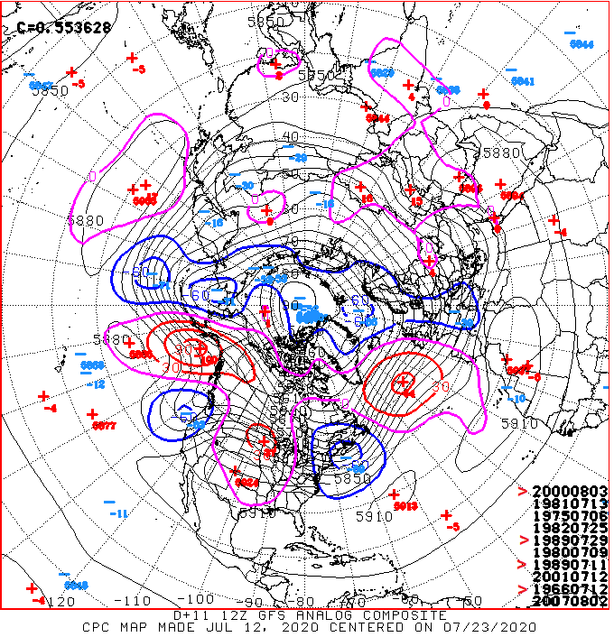 1966 is on the list and that’s a year I’ve talked a lot about since the cold back in early May. 2000 is leading the charge as the top analog with 1989 showing up twice. It’s interesting to note 1989 went on to give us the coldest December on record with 2000 giving us the 2nd coldest December on record.
We shouldn’t read too much into this, but it was something that jumped out at me when I looked at the list.
Make it a great day and take care.

Thanks Chris, The years 1966-67 we were coming off of a strong El nino. One snowstorm in early November and the rest of the Winter was uneventful. In contrast 1988-89 we were coming off of a strong La nina. After the coldest December on record which featured zero snowfall for southwest Indiana the rest of the Winter was uneventful. Interesting comparison.
Late yesterday evening we had a bout of severe weather with some cloud rotation noted. Very heavy rain, and high winds along with cloud to ground lightning. Rainfall total 0.81. Like you said Chris great day to be outdoors. Enjoy.
I am going to try to stay outside all day.
We might not see a comfortable day like today until mid September.
The high temperature at Chicago’s O’Hare Airport Sunday only reached 79 degrees, breaking an 18-day streak of high temps over 80 degrees, and a 17-day streak of temps above normal.
So far in July for Chicago, the average temperature has been 80.7 degrees, which is 6.9 degrees above normal, and would make it one of the warmest Julys on record if the average temp holds the rest of the month.
There have been seven 90+ degrees days in Chicago so far this month, while here in the SW suburbs at the NWS forecast office in Romeoville there have been nine 90+ degree days.
It’s a gorgeous day to be outside today, with a sun/cloud mix, temps in the low 80s, dew points around 60, and light winds.