Good Tuesday, folks. Temps are starting to climb as we roll into a seasonally hot pattern for later this week into the weekend. That said, thunderstorms are going to try to battle the thermometer and there’s even a dip in the jet stream showing up once we get into next week.
The first round of storms looks to arrive by Wednesday night into Thursday as a weak front drops in here…
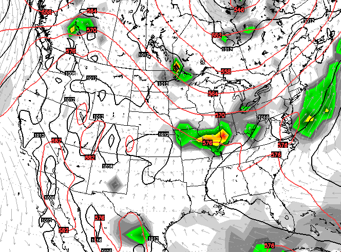
 This little battle is something the GFS has been showing for quite a while now, with the EURO saying no way. You know my thoughts on the recent performance of these two models… The GFS has been kicking the EURO all over the place.
Low and behold, we now find the EURO running toward the GFS solution. It’s finally seeing the storms and even a stronger cold front early next week…
 That’s a pretty good trough digging into the east next week on this run of the EURO…
 The control run of the EURO Ensembles definitely shows a ring of fire pattern over us for the next few weeks. Check out the above normal rainfall…
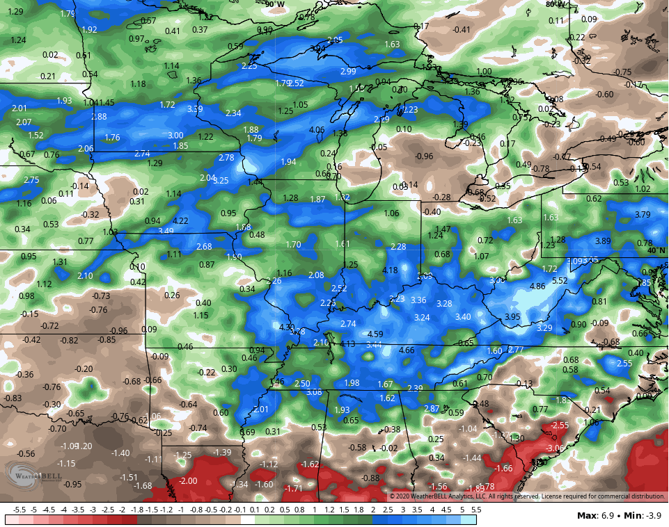
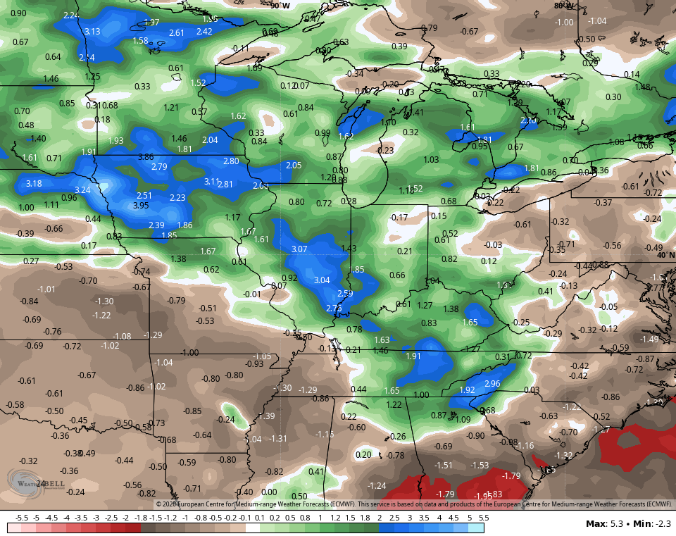 Recent runs of the GFS have a similar look over these next two weeks…
Have a great day and take care.

It’s actually been a touch dry of late in my area of Richmond. Not worried yet.
Moisture is just about right here in my county of Taylor. Great growing season so far.
As TennMark noted in Saturday’s blog comment section, this week is the 25th anniversary of the deadly Chicago heat wave, and he included a link from Wikipedia about the heat wave.
I’m going to include a link from the NWS Chicago web site, which contains a very thorough, comprehensive look at the 1995 heat wave and all the statistical numbers from it. In addition, it also examines the development of heat watch and warning criteria afterward based on the impacts of that heat wave.
To me, the most amazing statistic from the 1995 heat wave is the fact that on July 13th, the heat index was over 120 degrees (at Midway Airport) for six straight hours!
http://weather.gov/lot/1995_heatwave_anniversary
Thanks Mike, Great information from the NWS in Chicago. That was an unusual event for Chicago. I found the map showing the high pressure, which was completely “block” by surrounding low troughs interesting. At that time I was in the nursery business in southwest Indiana and we had the extreme heat (95-102) for several days, but not like Chicago had. Keeping my nursery alive was a chore, but we got through it with minimal lost of nursery plants.
The worse drought I ever been in was from 1987-1980. We thought it was never going to rain again. In May 1980, Mount Saint Helens decided to “blow her top” and push ash high into the upper levels of the atmosphere which caused the hot Summer in 1980. It was 1981-82 when the skies opened up with tons of rain thanks to a very strong El Nino. Just goes to show you that whatever happens in the atmosphere, whether it is big or small can change a weather pattern in a very short time, which makes meteorology an interesting study.
You’re welcome, it was a very comprehensive review of the heat wave for sure. Glad that you and hopefully others found it to be an interesting read.
It’s HOT today Chris with a blazing HOT Sun. Wouldn’t be surprised if it hits 90 degrees in my backyard. I am staying indoors in the AC where it is 72 degrees. Hope my old air conditioners hold out. LOL
Mike, You may be interested in this bit of information and it may have been a player in the “heat wave” in the Summer of 1995. In 1995-96 we were in a moderate La Nina and now forecasters are saying there is a 50% chance of a weak La Nina this Fall and Winter. If this happens we could have another “dud” Winter. Ugh !
I recall some posters commenting on arctic sea ice over the winter claiming it was rebounding, not really melting, etc. etc. I wonder what those same posters think now that arctic sea ice is smashing through daily records on a regular basis now and is at an all time low for this time of year? Where are those skeptics now?
I study the Arctic regions everyday and I find that the ice field is building and has been building over the Winter months for last several years. Now that we are well into the Summer months some lost of ice has occurred, which is to be expected and there was a heat wave in Siberia with record breaking temperatures. Now that the Earth is tilting towards the Autumnal equinox the milting of the ice fields has slowed. Interesting to note that snow is still around in Barrow, Alaska. Check out the Ventusky site of the current snow cover. https://www.ventusky.com/?p=48;-154;0&l=snow&t=20200715/0300