Good Monday to one and all. Our week is starting off with mild temps and a shot of rain, but this is not representative of how the week plays out. A series of cold fronts will usher in the return of winter and the action gets started late Tuesday. Each front that moves in will have colder air than the one before and each will produce snow.
The rain today slips in as a front works into the region and low pressure develops to our south and east. The heaviest rain will be across central and eastern parts of the state. Here’s regional radar…

Colder air seeps in behind this front, but the real cold doesn’t come until late Tuesday into Wednesday. That’s when an arctic front moves in with a period of snow along and behind it…
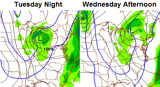
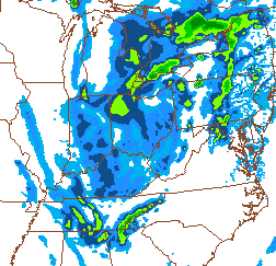
The HI-RES Nam Simulated Radar shows good coverage of the snow showers and squalls on Wednesday…
 This is a vigorous system that will also bring quite a bit of wind. I do expect some accumulations from Tuesday night into Wednesday and this may cause travel issues. Temps for Wednesday will be in the 20s for highs.
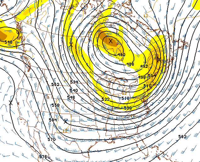
The next arctic front takes aim at the region by late Thursday into Friday. This will also bring a round of light snow along the front with snow showers and squalls behind it. Thermometers behind it look even colder as winds really crank up.
We may see another clipper work in behind that one over the weekend and that would put us getting closer to my famed “clipper mania”. 🙂
Overall, we are likely to see a couple of light accumulating snows before the week is over. Maybe some snow days? 🙂 The Canadian Model’s 7 day snowfall forecast thinks so…

The longer range call is for the late month return of some very cold air that would likely carry us into February. The GFS and GFS Ensembles are on board toward the last week of the month…
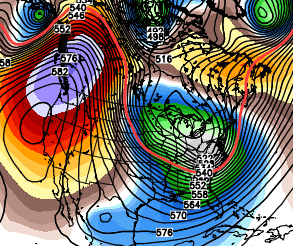 That has a wicked look to close out the month and head into February. In many ways… the worst of winter is likely in front of us. By many I mean snow. 🙂
Updates to come later today. Make it a great one and take care.

First!?! Woo-Hoo!!!
Thanks Chris. Well if it’s going to rain today it might as well be Monday! 😉 looks like winter is creeping back in. Maybe a good snow before this one is said and done. Have a great Monday, everyone.
I like this post! Were not saying anything big is going to happen, just light stuff! I just don’t like getting off school for an inch, that drives me nuts!
Here’s hoping someday!
From the NWS: 13 January 1978 → Beginning today, Lexington had at least half an inch of snow on the ground for 57 consecutive days (through March 10), a record.
I think two weeks is about the longest I’ve seen snow on the ground in the past 20 years. Even that 1994 snow melted within about 8 days.
i’ll be glad when the nonsense is over …. give me warm days on the golf course anytime. our 40’s forecast yesterday turned into a nice 56 degrees …. my heat pump appreciated it also and so will my electric bill.
Looks like a pretty boring week. Snow Globe type weather as bubbag would say. Not going to be overperforming clippers. Going colder by end of month. Hopefuly we can get a Apps Runner come through here during the next cold snap….Thanks CB for the update.
Yup I agree occasional flurries and snow showers maybe a dusting or coating other than that pretty quiet. Looks to be a breezy cold week in general. But nothing to write home about.
I bet frankfort area gets more snow this week than the southern fed overhyped past storms, 1/2 inch would be more than we got out of the last 1-4 inch miss!
Clipper mania! Hope to see the northwest flow continue.
Overhyped? Really?
the worst of winter is yet to come…which means more than a dusting …you heard it here first
haha
we hear it and read it everyday …. and those days come and go … it is always next week or next month;
bring on spring !!!!!!!!!!!!!!!!!!!!!!!!!!!!!!!!!!!
Then why do you keep coming back?
One week ago you had the coldest temps in 20 years for where you live.
the cold has nothing to do with snow …as we saw last week ,sub zero temps with barely any snow around
He plainly stated in his discussions that the snow was not going to be a big event during the Polar Vortex last week. More than once.
Again… why do you stop by then if you already know what’s going to happen?
It’s true, CB. I enjoy this blog because I’m actually learning things, adding to my life-long interest in weather. My grandad was a WWII storm chaser in the South Pacific and I’ve loved weather my whole life. I like the element of solving puzzles, and you know what, sometime the pieces fit a little differently that you once thought. It’s all part of the experience. Chris, you have our permission to block certain people from this blog. There are plenty of other places and other reasons to go and complain. Thanks for all you do!
I agree 100%.
I just wish this miserable rain would pull on out of here.
I am tired of the mushy mud!!!!!!!!!!!!!!!!!!!!!!!!!!!!
Some of us were wondering about that -0 degree reading last week. The good people at the NWS Louisville said their observation equipment registers temperature in Celsius. At -17.8 degrees C, the temperature would read -0.04 degrees F. They drop the tenths place in F and report it as -0.
I guess that means if the temperature is measured at -17.7 degrees C, the temperature of 0.14 degrees F would just be reported as 0 degrees?
Interesting and thanks for the information!
If anyone paid any attention at all to Chris’ forecast for snow during the polar vortex a week ago, you would know that he said the snow was NOT going to be the big story,it would be the temps. Guess what? He was right! He never hyped it to be a big snow maker. All the negative posters on here hype things up themselves, for the most part,and then get mad when the weather doesn’t live up to the expectations that they set forth. Chris is right–if you know so much, why DO you keep coming back?
I for one don’t mind the rain and somewhat mild temps. It gives a chance to wash off the salt and get some things done. Chris is not the only met calling for a return of the Polar Vortex towards the end of next week. If we can get the storm track to go, say 150 miles southeast of where it was last time, then we are in business for a good snowfall.