Good Tuesday, folks. The first in a series of cold fronts will cross the state later tonight and will bring some light snow and much colder temps our way. This whole setup is just a preview to what I think will become a harsh pattern for the last of the month into February.
Let’s start with the clipper coming in tonight. This will have a burst of snow along and behind it as it dives in from the northwest. A few snow showers will kick in behind it on Wednesday…
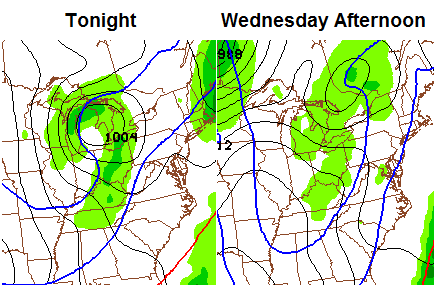
Can we get some light accumulations from this? Yes… especially in the east. That’s where we still need to watch for some enhanced snows from a weak wave to our east. Highs tomorrow will be in the 20s but will feel colder because of the wind.
The next system arrives quickly for later Thursday into Friday. Winds are going to be very gusty and could top 30mph as this clipper zips in. A band of light snow may surge out ahead of this by Thursday afternoon with another band along the actual front Thursday night into Friday morning…
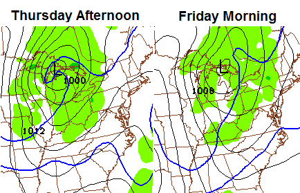
There’s some pretty good energy swinging through the base of the trough and that could spawn another wave of low pressure later Friday. The Canadian continues to point in that direction…
 That can easily lay down some light accumulations across the entire region and could be a touch more if the wave develops. That’s a lot of wind and good shot of cold that follows.
I continue to be all systems go on another stretch of harsh winter weather for the last week or so of January into February. I have very little doubt that the worst part of this winter is still ahead of us. We’ve had the brutal cold and there is a strong possibility it returns during this period. There is also an increasing potential for us to see above average snowfall.
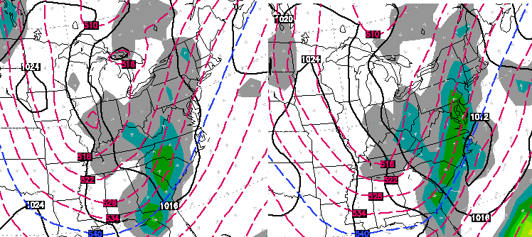
What am I seeing? The same thing I have been talking about since early Fall and that’s a building ridge into Alaska. I mentioned in the winter forecast that this would be the driving force of the winter and that’s been the case and continues to be the case. Check out the smoothed out European Ensembles for later next week…
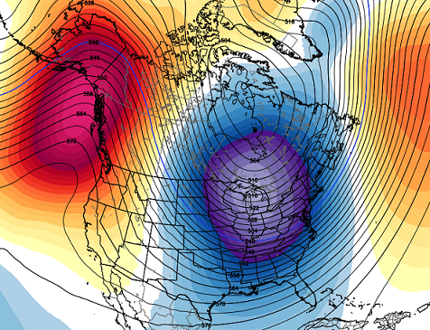
As that ridge develops, it forces a deep trough into the eastern half of the country. That can deliver bitterly cold air once again. Here’s a more detailed example of how strong that ridge near Alaska gets…
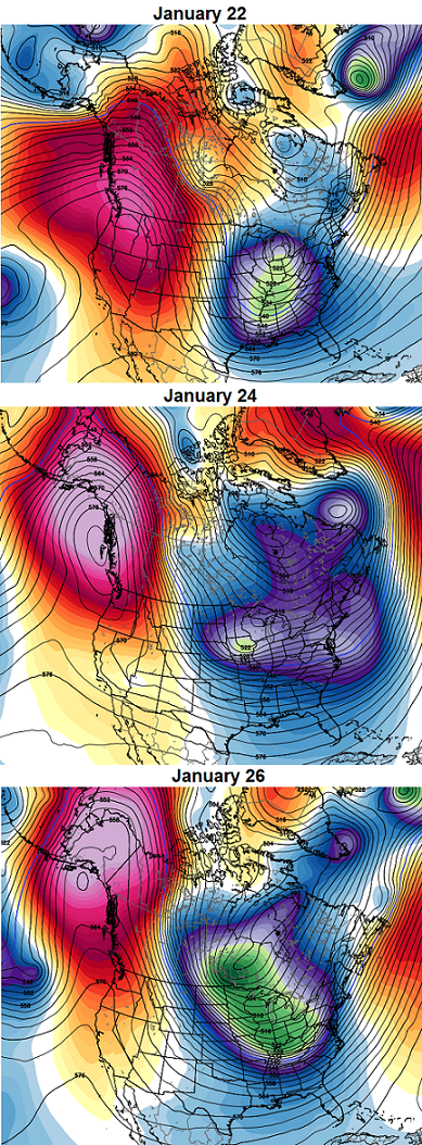
That is just massive and it also tries to connect with some blocking showing up over the top of the globe. You will also notice the evolution of the troughs in the east… it’s one right after the other and there is lot of energy digging in. That’s different from the last visit by the Polar Vortex as it just overwhelmed the pattern with cold and then split town.
This type of a pattern can produce a extreme winter storm in the eastern part of the country. That doesn’t necessarily mean it has a huge impact on our weather, but it simply means this setup can go wild.
I will update at some point later today. Make it a good one and take care.

I like the thoughts behind that data. Can’t wait to see how it plays out.
We need a big snowfall to get out and play!! I like the thoughts too. Enjoy your blog and read every day. Good job CB.
NWS issued a WWA for eastern Middle TN for 1-2 inches of snow tonight into Wed morning. Usually, we get the moisture plume straight from this part of TN. Should we use this as a gauge of things to come or will our snow be moving more east with the cold front??
While I would dearly love to see at least one pretty snow (several inches at one time) before winter is over, I really don’t want to see single digit and sub-zero temperatures. We had a pipe burst last week and fortunately we were home to shut off the water but I will be traveling the next five weeks and no one will be here during the day. It worries me.
Me thinks there will be very little, if any, snow with these fast-moving clippers. Hope I’m wrong. We need the southern stream to get involved SOON!
I agree with you there, but would rather have light snow and cold rather than cold rain to light snow. Unless we get the arctic air in here first we all know how the southern stream storms work out for most of KY. The pattern into the middle of Feb. looks promising for cold. Lets hope for a Apps runner or two.
Hey we may get some very very light snow (no snow map though–I guess it’s to light) and may get above avg snow later next week, this is exciting!!!!
Chris,
I have been a long time visitor to your site. I followed your forecast when you were on you other blog at wkyt before you formed this one. This is my first post. I visit two web sites every morning with my coffee, kyweathercenter and KSR. Although I wish it was sunny and 75 everyday, I do enjoy seeing it snow. Some of your people on the site do get off topic and complain, but that doesn’t really bother me. Most do more harm to them selves than to others when they comment complaints. I think complaining about the weather and those who try to forecast goes back to the beginning of the profession. All said, you do a great job and I think your forecast has the better possibility of being correct than most. Thank you and GO KATS.
GFS is buying into a skiff of accumulation through Sunday for the Eastern half of the state. http://wxcaster4.com/gfs/CONUS2_GFS0P5_SFC_ACCUM-SNOW_120HR.gif
Why does Bailey have two blogs? Just curious.
http://weather.bloginky.com/
he has one for KENTUCKY.COM as well as WKYT and this which is his own baby.
Black ice in north central ky was pretty bad this morning it took alot of people off guard. No major problems just alot of slipping and sliding on the secondary roads. The GFS looks like it’s catching on to the idea of convective snow showers/squalls region wide for later on tonight into tomorrow and again on Friday.
SE/EASTERN KY should pick up 2-5 inches of snow by weeks end. of course highest in the UPSLOPE mountains. lower in the TRI CITYS and north areas. as Bailey posted and ROLO says u want winter weatrher well CLIPPER MANIA for 4-5 days followed by a POSSIBLE MEGAPLEX for couple weeks or more?? then the same ones weres winter, I didn’t get no snow out that.. u said 1-4 inches and I got nothing. u will be begging OLD MAN WINTER to leave by the time he thru with us this year. the HEATMIEZER!!! and the SNOWDOME will meet its DEMIZE!!!!!!!!HAAAAAAAAAAAAAAAA
What are you seeing that I’m not?
Goats 🙂
Do you guys think that a Winter Weather Advisory will be issued for Bell, Harlan and Letcher Counties?
This seems to be one of those odd winters where the cold is readily abundant, but the moisture is not. Although the Pacific features cooler waters in the eastern equatorial region and warmer in the western equatorial region, it hasn’t been enough to create an active subtropical jet like we saw in 2009-2010. If we were in a weak el nino, rather than la nada, we’d be in a prime spot. To be sure, there is nothing worse than cold air and no snow.
Mets on some sites are just now talking about the cold period that CB has been talking about for quite some time now.