Good afternoon, everyone. Our first clipper arrives on the scene this evening and will bring gusty winds, cold temps and some snow to the region. This is a pattern that has a few more clippers lined up for the rest of the week into the weekend. It’s all part of the overall process of taking us into a harsh setup next week and beyond.
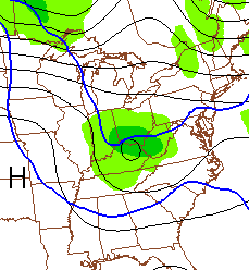
This evening’s system will race southeastward and will give us a 10-15 temperature drop in a just few hours. Winds will gust up as a band of rain showers ahead of the front turns to a band of snow showers after it passes. Snow showers will then kick in for Wednesday and these could be strong enough to reduce visibilities and slicken up a few roadways.
The next scoots in later Thursday and Friday and this one looks to pack more of a snowy punch…
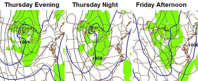
Winds will become very gusty and may top 30-35mph. That’s a nice shot of cold air that follows that up for later Friday and Saturday and could send Saturday morning readings into the high single digits and low teens for some.
That depends on how quickly the next system arrives this weekend. The models continue to point toward a clipper coming right at us on Saturday night…
As I’ve talked about for a while now… this leads us into what is likely to become a very harsh pattern for much of the country. That looks to start next week with a significant trough digging in by the middle and end of the week. That’s followed up by shots of bitterly cold air that will likely spawn snow systems.
I will stop by for another update later today. Enjoy it and take care.

Frist? Like the winter feel of the blog. Hopefully after today’s rains it will be the last we see for the rest of the winter.
Thanks for the update CB!
THINK SNOW!!!
Thank you Chris. I appreciate all you for us weather weenies;-)
Thanks Chris. Hoping for some snow love for the whole state before winter is done! Have a great afternoon all!
Thanks for the midday update!! I’ve been a weather weenie all my life and have been a follower of your blog since I discovered it back when you were at WSAZ. Thank you for all you do to keep our area prepared for what is coming in our up and down weather patterns!
I’ve followed this blog for the last three or four years of my teaching career to get a heads up on things that may impact our school day. I love it and recommend it at every opportunity to my co-workers. I have a question. A local weather man in south central Kentucky forecasted this morning temps in the 50’s on Sunday. I’m very confused after looking at this blog and those maps. Please clarify how this could be possible. Thanks so much.
Its not possible for temps to be in the 50s this weekend
Well if it isn’t going to be 75 and sunny might as well be cold and snowy. Convective snow showers and Alberta Clippers can be tricky and sometimes nightmarish for meteorologist these little quick hitting systems tend to have a mine of there own especially if they become overachievers. I know there is one met in Louisville that is not a fan of Alberta Clippers because of there chaotic nature. Apparently these clipper systems has messed up his forecast one to many times.
Marc Weinberg?
ty CB,
Thank CB for all you do. Looking forward to the daily snow threats. Hopefully everyone will get in on one or all of the clippers coming our way. God bless!
Thanks*
This will be the 5th straight day that hits 50 or better in Lexington, but looks like that is about to go to the wayside. I’ve enjoyed this “January thaw.” Now ready for some clipper mania! It seems to me clippers often overachieve along the I-64 corridor.
We are due an overachiever in the Frankfort, Lburg area, maybe it begins tonight?
Looks like we get 3 chances in the next five days. One of them is bound to overachieve!
East Ky looks to be in the sweet spot for these clipper systems, 1-2 inches in the higher upslope areas look very possible, deck dusters mostly to the west of I-75.
A “Bread & Milk” alert will surely be issued for some of these systems, stay tuned
So Joe Bastardi from Weatherbell.com just tweeted:
“I have never seen this cold a run of the ECWMF ensembles day 10-15. Outrageous”
Anyone seen that model lately who can post it?
I think the GFS is showing similar numbers. Similar to January of 1985. Looks like worst be around the 25th-30th–same thought as Chris has. I wonder what the indices are showing? Is the PNA still positive? And the NAO and AO negative? 1985 was not a cold winter overall but featured some brutal shots of cold air—and finally that elusive big snow in February 🙂
NWS Jackson about to issue a WWA for part alot of the area. Here’s the discussion…
HOWEVER…THE SNOW SHOWER ACTIVITY DURING
THE DAY ON WEDNESDAY HAS A DECENT SURPRISE FACTOR AS THE 500MB TROUGH
HAS A DECENT VORT MAX WITH IT. THIS MEANS THAT THERE WILL BE ISOLATED
AREAS GETTING SNOW SQUALLS PRODUCING ISOLATED ACCUMULATIONS GREATER
THAN A HALF INCH. HAVE KEPT THE MOST AMOUNTS OF SNOW CONFINED TO THE
HIGHER TERRAIN AND TIER OF COUNTIES TO THE EAST AS WELL AS THE
TERRAIN BORDERING THE CUMBERLAND PLATEAU REGION. A FEW HIGH ELEVATION
LOCATIONS ALONG THE VIRGINIA BORDER MAY SEE A 3 INCH SNOWFALL TOTAL
BEFORE THIS EVENT IS OVER. ALL THIS IN MIND…HAVE DECIDED TO ISSUE
A WINTER WEATHER ADVISORY FOR THE MOUNTAINOUS AREAS AS WELL AS A TIER
TO THE WEST AND KEEP THE EXTREME WESTERN COUNTIES IN A SPS.
Midnight – 6:00pm Wednesday
3 pm for my area
Thanks Chris! Are we still expecting 1-2 inches in Eastern KY tonight?
A Friday snow day would be fantastic! With MLK day Monday…4 day weekend for teachers and students!
Looks like we have a little snow coming our way,I will take it.
And here comes the leading edge of the cold front rain has begun in Louisville and the winds have picked up right on cue.
yell I just came in after working outside on my van.
the winds are incredibly gusty.
I hope Alberta brings us a gift that has a frozen concoctions as the main headliner.