Good Wednesday, everyone. Old Man Winter is about to flex some muscle and totally take control of the weather pattern for the rest of the month and into February. This threatens to take much of the country into a harsh period that features a lot of cold and plenty of snow chances.
The first shot of cold worked across the state last night and is producing snow showers and flurries today. Highs will top out in the mid and upper 20s for many today. Gusty winds will make it feel like its in the teens at times.
The next clipper zooms in here late Thursday into Friday. This is a more dynamic system that will have a better shot at putting down snow across the region…
 Yet another clipper tries to swing in during the weekend and takes a track right on top of us….

Between the late week and weekend system… I can see several areas picking up on a few inches of snow.
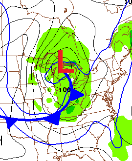
The main winter action arrives as we go into next week and beyond. I’ve yapped about this setup for a while now and the models are going wild with it. Watch how the GFS Ensembles grow colder in the coming days…
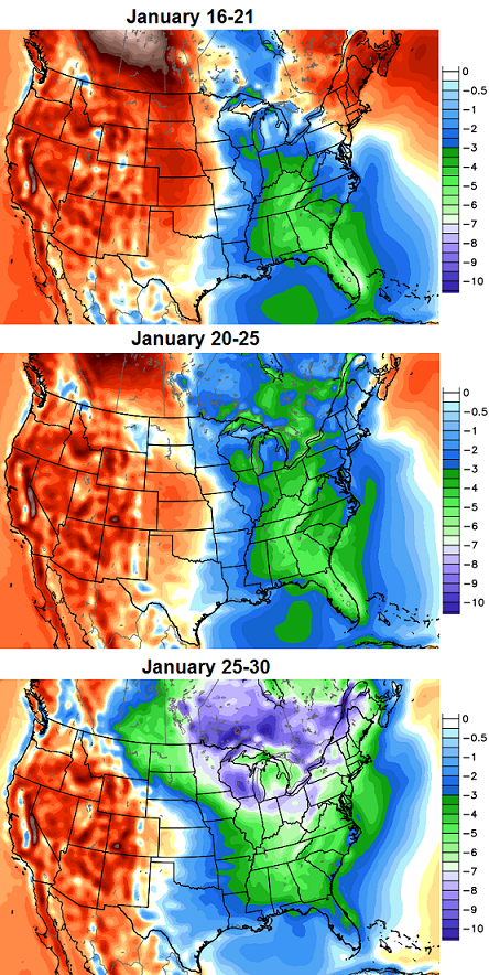 Those are temperature departures in Celsius. That’s some serious cold engulfing much of the country.
The European Ensembles for the last week of the month are also off the charts cold…
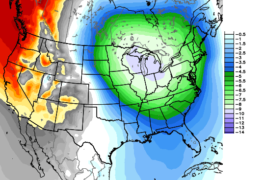 Check out how far south that cold gets. Hello, Cuba!
Extreme winter weather is a good possibility for the end of the month into the first half of February.
Have a great day and take care.

Cuba? Really Chris? Im getting married in the Keys the 25th and cant escape cold weather? Great.
Wishing you the best. I got married back in the fall (in Tennessee) and the wx lucked out pretty well for us. Nice sunny conditions, if a bit windy.
The all time record low for Key West FL is 41F. IIRC, even Key Largo FL had a brief rain/snow mix in Jan 1977 (same day it snowed in Miami and Homestead FL).
Appreciate the well wishes. Just looked at the GFS and it actually shows a significant snow here while I am gone. That would figure
My wife loves snow skiing, while I’m a bit more of a warm wx person. I have yet to snow ski, but perhaps I don’t know what fun I’m missing even though I can imagine me ending up in a full body cast 😉 . Anyway, we will likely make a trip sooner or later to a place like Gatlinburg.
It’s said that marriage is about compromises 😉 .
If the temperatures are 6-8° celcius below normal,what are we looking at here? Also,what is 1 Celcius equal to in Fahrenheit please? Anyone that has the answers to my questions would be greatly appreciated for providing the answers. Thank you CB for all you do.
I believe that 1° in the Celsius scale is equal to 1.8° in the Fahrenheit scale. So if the temperature is 10° below average in C it is 18° below average in F.
Thank you very much for that information. I really appreciate it.
Lot’s of hits came up on Google, such as:
http://www.fahrenheittocelsius.com/
Thank you for the link my friend.
Celcius X 1.8 + 32 = Fahrenheit. But like TennMark said there is loads of hits on google.
So for us average temp is 35 F. So we take this formula and say -5 X 1.8 = -9 F so take our average temp 35 F -9 = 26 F. I took all numbers as average. So when you are looking at a -5 C departure that means for us about 9 F below normal. CB can give much better detail than I can on this because he could say what the highs and lows would be. Either way it is going to be cold.
I think the best takeaway from this is to note that temps that far below normal for us mean remaining below freezing for the entire day as well as night. So if there is snow involved during the time frame, it sticks around.
Which if you took what the ensembles were showing as absolute truth it would mean we would average around 28-33 degrees for the last week of January. Which is about 15 degrees below normal.
Call me crazy, but that’s not that cold???
do you know what the average temperature is for January?
41°F highs average
Yes, but the average temperature for the month January in Louisville is 34.9°
32.9 for Lexington
35.7 for Bowling Green
32.5 for Frankfort
looking at northern Kentucky the normal high temperature is 38° with an average temperature of 31°
About 41F
Also that’s only the average high…..the actual average of the week would be lower
It’s going to warm up and rain, LOL
Seems like the perfect temp for snows, as it seems most of our big snows are usually with temps in the high 20’s low 30’s
Just saw a Louisville guy predict 58° Monday. Huh?
Any hope of getting the southern jet stream involved?
Joey, see SKYDOG three up! That is what KY gets when the southern jet gets involved. LOL.
As a kid I would get so excited watching the weatherman on TV start talking about the “JET STREAM” dipping down south then coming are way bring snow with it, but that doesn’t happen anymore! It dips south then rides the OHIO RIVER bringing RAIN with it!
Ky trends for the past 15 years. Need the cold air here for awhile before we get a Apps runner with moisture from the Gulf. And while we are add it let it stall out over Md and throw Atlantic moisture back over the Apps like the 98 storm! Now that is a dream storm?
At it!
Looks like KY’s chance for cold and snow are on the rise. My money is on the cold, but not the snow. Just trying a little reverse psychology here. I am with bhopper and perfect temps for snow in our area. Could get very interesting around here towards the end of the month.
Thanks CB for the update.
41 when I went to bed, 34 when I woke up…tough on the Swath Monster to make snow out of water without a key ingredient.
Wonder what kind of set-up produced this?
15 January 1863 → Thirty inches of snow fell on Cincinnati, OH. The snow came on the heels of 16 hours of rain.
1863? Has to be inaccurate records.
Wow. That was during the Civil War at that. Wonder if that was partly an extreme lake effect event? Lake effect snow from Lake Michigan has been known to fall as far south as northern Alabama, even if not nearly as heavy that far away.
While I usually use NWS Nashville, I also like NWS Louisville in part because of the bits of wx history they have on their homepage.
Unofficial reports of 30 inches, but officially 20 inches for this Cincinnati.
http://jbcmh81.wordpress.com/january-14-15-1863/
…for this Cincinnati storm.
Wow even back then there was a fence running down the Ohio River. Louisville and Lexington where flooded I bet.
I would love to know too @Chris Mercer!
goooooOOOOOOOOOOD Morning bloggers and BAILEY BOY………….
Blowtorch… lol.
Looked like someone rolled the dice and missed on that one. Oops
What I want the dude who said blowtorch prediction to say now is its going to RAIN ALOT!!!! That way it will SNOW ALOT!!!!!!!!
OK, I’ll play along. Heavy rains the rest of the month, with little chance of any accumulating snow. My reverse psychology worked regarding temperatures, let’s see how it works now. LOL
THINK RAIN!!
Being from Houston, I’ve never seen a white Christmas, (the one they had in 2004, I was in Lexington.) When I moved here, it seemed to rain every single Christmas, so sophomore year, I joked with friends that I was an elf, and every year I turned the snow machine on, and it rained, so that year, I would turn the rain machine on. Sure enough, Christmas of 2010 was white around here…….I was just not in town to see it, and I still remain hopeful to see snow on Christmas somewhere, some how.
That was random, but the reverse psychology comments made me think of that!
No snow in Louisville.
My part of Hardin county is now getting the best snow we’ve had all season. Fluffy flakes coming down hard and coating everything but the roads. It’s lovely.
Enjoy it, I think that’s about all we’ll see this month & next. Just going on recent history.
BPS
lol BPS makes his long awaited appearance after being dead wrong about the last system.
Dead wrong? I was dead right from one week out! I said it wouldn’t get as cold as predicted & we wouldn’t get anything as far as snow accumulation.
BPS
Ummmmm where were you??? It got every bit of what was predicted with the cold.
BPS said the temps wouldn’t get to -10 or lower like the mets were saying because, like myself, he and I both said it would be a rain only event. And it was do louisville/hardin/nelson county.
Do should be in *
I don’t remember any mets in Louisville saying it was going to get -10…I know a couple at first said maybe -5 but none officially said -10 or lower
That’s correct & thanks Shaak. At the time the actual temperature at my location was 61 degrees. Lows from -5 to -10 were being called for. We said there was no way we’d see a 70 degree drop as there had only been one or two of those in recorded weather history in KY. It hardly snowed at all or just rained & the low temp wasn’t close to -10.
BPS
Pretty snow lightly falling on the east side of town.
Had a nice little snow squall in Lawrenceburg. Temp dropped to 26 during it. Now back up to 31–most everything has melted.
Occasional snow squalls in western KY today – some of them moderate intensity for a short time. Central and east KY usually do better with clippers; most have missed us in recent years. Best one I remember was in 1997 when a clipper dropped three inches on Owensboro. Back then, when we’d miss out on a good southern snow event, we could usually count on some half-way decent snows during very cold outbreaks. That really hasn’t been the case in recent years.
yep BJENKS WRAPAROUND stalled out storm, remember that was what haqppen in 1987 wasn’t it? SE KY got drilled as we headed into spring, that I remember more than 98.
we left Clay County and there was 20 plus inches on ground as we headed to Indy to play the state champs after winning the STATE TITLE in basketball.
Crazy as it sounds, once we get past the first ten days of February the chances of a super cold and snowy period really start to go down. That doesn’t mean it can’t snow or be cold, it just means the chances of super cold go way down and any snow that falls likely won’t stick around for long.
My memory may be a bit hazy, but I think the first week of February 1996 is the last time we had real arctic shot in that month. And while 2010 featured two big storms in February, it’s really tough to get anything cooking past the middle February. Maybe this winter will be different, but if things don’t match up in the next 20-25 days or so, we may have missed our window.
What we really need is the southern jet to become active. The cold has been there all winter, but the moisture hasn’t paired up with it too well so far.
I pointed this fact out last week and was not well received. I said if we don’t get a big snow in the next several weeks our best window will have closed. Average high in Lexington February 28? 50 degrees.
Here’s hoping one of the next few weeks has a good snow for all of us.
the term Arctic is used far to much. I’m hoping we will have more than 1 snowfall to exceed 1 inch totals so far the only thing to write home about is the few days of below 0 temps but we are at the half.
I would agree that the chance of a prolonged period of cold goes down. However, some of our biggest snows have been in Late February and March. They just don’t usually stick around very long. The exception to this is 1960–winter really got started in Mid-February. From Mid-February to Mid-March most of Kentucky received 30 inches or more of snow and temps went below zero in March.
Any idea how much snow SE/KY gets tomorrow night?
My guess would be about the same as we saw last night and today…..absolutely nothing unless you’re in an extremely high elevation.
Again, I have to state that the storm of the century was in March and April, 1987 we had 3 feet of snow and neither of those were in January or February. Like Chris said, plenty of snow chances yet to come.
Interesting map showing which states were hotter or colder than normal in 2013.
http://www.ncdc.noaa.gov/sotc/service/national/Statewidetrank/201301-201312.gif
Where is the one for the moisture
Here is a link for the article
http://www.ncdc.noaa.gov/news/ncdc-releases-2013-us-annual-report
In addition to occasional snow falling in Kentucky, a little snow now being reported in Clarksville TN and to the southeast of Clarksville on I-24. Just cold clouds for the moment in Nashville.
The Tennessee Plateau might get some minor accumulations this evening.
Chris – MJ – etc…
That difference in the Airport and mesonet in Lexington is driving me crazy!! If anything, the mesonet was always the “slightly warmer” of the two…..and now that BGA is warmer, something is wrong….I had a sneaking suspicion the “official” low (which was -4) at BGA, yet it was -6 at the mesonet makes me wonder had the BGA apt thermometer , which used to be slightly always colder than the mesonet, could have actually tied a record of -7 that morning…….who knows……but someone needs to check the accuracy of that thing
I had -7 in Lawrenceburg. Up until about a year ago, my low temperature almost always matched that at Lexington. Now I am consistently 2 to 3 degrees colder.