Good Friday afternoon. Snow showers and squalls continue to do their thing across the state today. My suspicions of thunder and lightning being noted with some of these turned out to be correct. Lots of folks across central and northern Kentucky had some loud booms this morning.
Additional accumulations will be noted in the heavier squalls this afternoon and early evening. Winds will continue to crank as temps drop into the teens. Wind chills may head close to zero at times. Lows tonight may hit the high single digits and low teens.
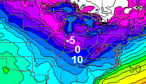
The next clipper zipping in from the northwest looks to pack a pretty good punch. Take a look at the simulated radar from the NAM…

That has the potential to bring a swath of 1″-3″ snows with it… especially across the northern half of the state with slightly lower amounts in the south. Winds will be gusty and that means some blowing snow is likely.
The cold air overwhelms the pattern early next week. Temps Monday will drop through the 30s and 20s as a srong front drops in with some light snow into Tuesday. That’s when highs drop into the teens and try to stay there for the rest of the week. Low temps may threaten to hit 0…
 There will be a couple of snow systems diving in here next week. One comes Monday or Tuesday… another by late week… then watch next weekend into the following week. That’s the period to watch for our first storm threat as the polar vortex starts to work southward again.
We have a brutal stretch of winter weather ahead for much of the country. You’ve been warned for a while, now. 😉
Have a good one and take care.

Let me know when SE Ky is expected to get more than 1 inch of snow
Let me know when you’ll get quit stalking my posts.
You the man CB. Thanks for all your hard work!
Thanks Chris, and good call on the Thundersnow, Frankfort had some this morning, fun times coming if you like winter 🙂
Little drizzle mixed with a few flakes in knott co earlier that lasted about 5 mins
Nearly 3″ in NE Louisville. At 2am this morning, wave 3 Weather blog had Louisville metro getting between a dusting to 1/2″ of snow. Isolated 1″ amounts North of the river.
So, it is nice to see snow over perform around here.
Lets Hope this is a new pattern developing, overachievers 🙂
I’m all for it!
The bad thing is if you listen to them this morning they act like they called for this 1 or 2 inches since last night…they won’t admit that they were wrong and that it iver achieved.
Well, the Noon forecast from Wave 3 has tomorrow’s system putting down, yes, you guessed it…1/2″ or less of total snow through Sunday.
Let’s see how it plays out. I am leaning more towards Chris’ 1-3″. Idk what Wave 3 isn’t seeing with these clipper systems. Yes, they are fast moving. But, can pack a punch in a short time frame.
I measured 2.8″ officially. However, Louisville is about as backwards as it comes with their “official” snowfall totals that go into the record books, always coming from SDF (airport), where there is ALWAYS going to be natural heating being put off by all the jet fuel, etc…
Makes zero sense to me why any city would ever want their official snowfall reading to be from an island that routinely has temps a good 4-5 degrees warmer than the rest of Louisville.
c-Biv, Most weather folks push the Global Warming/Climate Change agenda/religion. Placing the official temperature gauge for the city at the airport gives them the warmer results they are looking for and help them show other they are right. It is all a scam.
Thanks, Chris!
The good news is that it’s finally snowing here in Harlan County. The bad news is that it isn’t sticking. 🙁
Congrats on the thunder snow call yesterday, Chris! Not sure the NWS offices even know what that is … lol.
That NAM simulated precip takes on a big comma shape not unlike a big juicy southern storm! Here’s hoping it takes a track favorable for at least 2″ for most of KY!
Been snowing all day in MadCo and NOTHING to show for it. I am officially resigning myself to the fact that my poor child will never see a snow like I did when I was her age (back in ’77 and ’78.) Good thing I have pics to show her. 🙁
MJ, on his Twitter feed, seems interested in the storm on or around the 24th. If the PV is heading south, one of these systems is bound to generate a big storm in the area. Of course after watching so many skirt by to the north, now we’ll probably have to fear a suppressed track to the south! Ahh, life as a snow lover in Kentucky.
Yeah if Chattanooga gets a good snow while we get a skiff, I’m gonna lose it. However I’ll be in key west so we prolly get thumped.
Thanks Chris! Glad I read your blog! I knew to wear my long johns today! 😉 We’ve had everything from sleet to big snowflakes to graphel this morning. Right now, we have flurries with the sun trying to peek through. Hope to see some more of those heavy snow squalls come through. Love watching it snow! ONe of theses days,m we are gonna get fooled and get a BIG ‘un! Stay safe and warm fellow weather lovers!
Meant to say that the winds have picked up a lot and the temp is going down in a hurry! Down to 25, and windy here now. Brrrr!
We are up to 2.5″ here and it is still snowing off and on.
The official NWS total for Lexington is 0.3″ as of 1 pm. Seems a bit low. In SW Lexington we have around an inch or so. Maybe the airport didn’t get under that heavy snow band we had a while earlier.
Clays Ferry didn’t get the heavy snow band that you did either. my deck is barely dusted with snow.
The official total for the day ended up .3. I don’t know if that is true or not–I drove over to Louisville this morning–easily 2-3 inches here on the East end.
Thanks Chris! You’re awesome! Is there a meteorological reason the Lexington/Nicholasville area seems to miss out on the snows? (Other than elevation when compared to some areas.)
Not sure why you missed out. I have 2″ south end of Lexington.
We’ve just got a dusting. Guess the scattered nature of the squalls prove Chris right again! 🙂
That Hi-RES NAM map looks great…but then again, it’s the NAM. Can’t get too excited based on its performance this year.
Reader who rarely posts but here in E-town we probably have an easy 2.5″ . It’s been snowing all day and at times it was very heavy…and big beautiful flakes! Finally, a nice snow!
All this snow is really putting a crimp on my motorcycle riding!!!
That is hilarious!!!
Moderate to heavy snow shower in Valley Station. Not much to look at on radar, but signatures depict quick hitting band. I’ve had two bands move through in 20 minutes. Put down another 0.1″ or so. These flakes are less wet than this morning’s.
I have just under 1″ snow depth.
Man what runs the models are showing lately…As some alluded to watch the 25th time frame..Also Feb. is looking awesome..The Atlantic looks to finally cooperate..Blocking keeping the cold air in place for an extended time..Southern stream finally coming alive..Man I’m excited…If we don’t receive a Big,Big snow some where in between Jan 25th-Feb-15th i will officially hate winter from now on..