Good afternoon, gang. The blog is now in Winter Storm Threat mode for the increasing potential of 4″ or more of snow across parts of the region. If my confidence increases, then an upgrade to Alert will take place late today or tonight.
Here’s a look at the early call on snowfall…
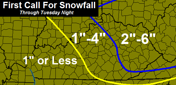
We have an artic front diving in from the north and this will have a wave of low pressure developing along it. This wave looks stronger with each model run. With arctic air pouring in… snow ratios will be greater than the typical 10-1.
Regardless of how much snow falls where you live, this will be a high impact travel event across our region. Snow develops late tonight and it’s likely to be snowing at a good clip during the morning rush hour. Wind gusts of 30mph will be likely during the day and this will create some blowing snow.
Thermometers drop into the high single digits and low teens by early Tuesday evening. Readings may flirt with 0 or a tad below by Wednesday morning.
Another arctic system dives in late Wednesday and early Thursday and may knock our temps down even more. This may also deliver another shot of light snow.
Additional snow chances will be with us this weekend into early next week as arctic blasts continue to take aim at the state.This is a harsh period of winter upon us.
Your friendly weatherdude is scheduled to be wheels up to Minneapolis later today for a business trip. As of now… that is still the plan, but could change.
Take care.

Thanks for the update CB! Is it safe to say probably no school for the rural counties surrounding Louisville? Bullitt, Spencer, Shelby etc. ?
Shelby is closed Tuesday anyway, since it is a professional development day for the district.
I respect your forecast Chris but I will not get my hopes up and expect more salt than snow as has been the norm in Knox County. Have a safe trip
Andy,I hope you get a big snow before winter is over my friend. You deserve it.
Thanks Ben
Will all the dry air factor in again? I feel like it was ignored with the last clipper.
I don’t believe this is a clipper and moist air from the gulf will be in place, I think.
This is what JKL says about the dry air….
FOR SPECIFICS ON THIS SYSTEM…THERE WILL BE A SIGNIFICANT LOWER
LEVEL DRY LAYER PRESENT OVER MUCH OF EASTERN KENTUCKY…SO IT MAY TAKE
A FEW HOURS FOR PRECIP TO HIT THE SURFACE…ESPECIALLY WITH WARMER
AIR IN THE VALLEYS OVER THE SOUTHERN CWA.
Alert…’business trip’???
I hope this snow forecast (sticks) pun intended 🙂
6 inches would shut down east KY schools for the rest of the week!
2 inches does that
come down and drive some of these moutain roads with one inch on them
try 2 weeks if the Polar Vortex shows again
True!
Some of the mountain schools will be going half the summer.. Oh well, just the way it is living in the hills. Its our gift and our curse!
I always hear that, but it doesn’t actually happen. Kentucky law states that once a school has reached 20 snow days the rest can be forgiven. Most of these schools are nearly there and most had built in days + were scheduled to get off a week before June. The most they’re ever in is the 1st or 2nd week of June.
Don’t leave us! I need to know what’s going on!
Chris enjoy all that beautiful snow up North and have a safe and pleasant trip.
Chris, thanks a buch… I hope that your “business trip” is about you becoming the new QB for the Vikings and not a new weatherdude up in that area… Keeping my fingers crossed… 🙂
Thanks Chris as always for watching over us.Maybe we will all see a little snow.
WSAZ is just calling for my area to have 1-3, w/the WV mtns to have closer to 6..I know that 1-3 is in the 2-6 that Chris has on his map..but gosh I’d like to have closer to 6 than to 3!
WSAZ should just publish CB forcast as it is correct more times than their own.
Thank you CB for all you do. It is greatly appreciated. Have a safe trip and please put in a good word with the Snow Wizard so they will send some good snows are way. Have a great day everyone.
*our way
Wow! What a difference a few hours makes! This morning it was a chance of light snow to now threat mode. I love it! Hope it happens and overachieves. Have a great trip, but make sure to come back to Kentucky.
Do we know the timing of the snow in central Kentucky? I wonder about buses on the roads for students.
I remember just 5-6 yrs ago all stations local mets would forecast 1-2″, 2-4″, 3-5″, 4-8″, 6-10″
there weren’t ranges of 1-4 and 2-6 back then….I guess its gotten harder to forecast qpf with all the new upgrades to computer models?
NWS sounds gun shy on putting out any advisories in KY, they don’t trust the models, I can’t imagine why?
Staying positive today for hopes of a better outcome this time!
Looks like they found their darker shade of blue though. Changed most of their 1-2″ areas to 2-4″ and their <1" areas to 1-2".
That was NWS in Jackson by the way.
Looking at preliminary readings from short-term models suggests to me that this will likely become a high-impact event for tomorrow morning’s commuters. Therefore, widespread Winter Weather Advisories will be forthcoming.
Betting the farm on 1 inch or less for Wayne County!
Advisory up in Northern KY for 2-4 with locally higher amounts!
This Michigan girl is wishing for a nice deep snow (which here in KY means at least 2″!!). I will take that for sure. And Chris, I am addicted to your blog!!! Hoping Matt in Richmond isn’t having a premonition! Don’t leave us!
For those asking..snow should be developing right around/before daybreak
This is a clipper system however what’s going to happen is a low is going to develop along the front this low should develop over eastern KY. This low will getting organized fairly quickly. The biggest problem is figuring out exactly where the low forms in eastern KY dry air should not be a issue with this system the low that develops should dominate and quickly scour the dry air out. The system will be developing right on top of us so it’s going to be really hard to gage snowfall amounts. However CB’s maps look good. The further east you go that’s where the heavy snows will be. Advisory’s will go up. Would not be surprise to see some winter storm warnings for eastern half of KY.
Looks like I’ll be missing the fun on this one. Just an inch or less forecast for my area.
Me too 🙁
Not really sure what to expect, since my county is split between the 1″-4″/2″-6″ zones. The NWS in Jackson is still forecasting less than an inch for Harlan County.
Have a safe trip, Chris!
Easy, 0″-6″ that’ll do it!
Inch or less for the metro which is par for the course. I’m reliving that 3.9 inch snowfall we had back in December. Those were the days.
For Louisville metro???
well who told u a bigger snow was coming for us MTS peeps.. I see a WSWARNING ISSUED BY 4PM AND A A even stronger snow than even bailey see now. we are going see a heavy snow in a quick period, BUT I also see signs of a possible STALLING out to. not a done deal, but if it does as the low trys pull out look out BACKLASH for east/SE KY. sticking with my 4-8 as I postd early for now.
not the 1st time you have seen something that just didn’t happen ole buddy 😉
Rolo, please, just don’t. 4-8″ just isn’t going to happen.
DRY AIR not as poster said the low will develop close to us in ky and will RAPIDLY DEVELOP, OUR SNOW not coming from west it will explode right on top of us and roate inm around the low.
only bad news is BABYSITTING SUCKS..
This is a Nowcasting storm if their ever was one, a low developing in eastern KY all depends how fast it developes on top of us!
My money is on east of I-75 getting anything more than 2 inches, west of I-75 cross your fingers for 1 inch!
Thats pretty much my thinking too. I dont think mother nature is gonna give us in central KY much love outta this one. Hoping I’m wrong.
Hope we get a good amount of snow in Louisville. We are in Chris’ 1-4″ range so I hope we get closer to 4″.
I used to live in Minneapolis for a year (one winter.) It was during the warm 2011-12 winter. About 20 something inches fell that season and it was one of warmest and least snowiest winters. I should have taken advantage because I was really disappointed that winter because usually there’s 50″ in an average season but it was 20″ which is high for ky standards. Even Minneapolis least snowy winter on record was 14″.
Expect widespread winter weather advisories from NWS offices in Louisville and Jackson with some embedded warnings for far east KY. This is based on preliminary readings from some short-term models. Amounts do not look impressive yet, but the storm part of the forecast is not factored in yet. Give it a few more runs. By this evening, potential amounts may become clearer.
Okay Chris, we need to talk about these, “business trips”. One does not take a business trip to Minnesota in winter, one goes to the Bahamas for winter business and Minnesota for summer business. 😉
Job Interview?
Come on Chris that would be taking your love of winter weather to a whole new level!
Weather Nation 😉
WWA posted for most of the Louisville area
Thank you Chris! Please don’t go if this trip means you could be leaving us. We lost you once and finally got you back home.
I was only joking Char
You never let anybody know your looking for a new job (except your wife) until you have nailed down. Chris isn’t choice g anywhere.
Until you have it nailed down.
Chris isn’t going anywhere.
I hate this iPhone spell check
It did occur to me that maybe he was moving on to a state that really did have snow. I wouldn’t blame him being the snow lover he is!!
Problem is people in Minnesota hate snow, we would to if we got as much as they do. Good to see you back on the blog
Been here all along just no comments.
Yeah! I have a FB friend who lives there. She said she send some of hers down here. Hope you and your family are well.
NWS has wwa for 1-3 inches for Laurel….come on guys, we can do better than that…maybe??
Where is this system right now?? Perfectly sunny and 49 deg here in the Capitol City
not formed yet per NWS discussion
A BLAST OF ARCTIC AIR AND A STRONG UPPER LEVEL DISTURBANCE WILL MOVE
SOUTHEAST OVER THE AREA. THIS WILL TRIGGER AN AREA OF LOW PRESSURE
TO DEVELOP JUST TO OUR SOUTH EARLY TUESDAY MORNING…
Keeping fingers crossed and hoping for a surprise. Someone will see a decent snow….hope it’s me!!!
CHRIS BAILEY is at a CONVENTION/TRAINING u dummies.
I have tweek my totals 3-6 inches.
Going the wrong way
Rolo stop being a jack@$$.
Snowfall totals are being increased to the east and Neast of us! Maybe that trend will move further west into our area?
GFS has jogged a little more south putting some of Eastern Ky in the sweet spot…Tonight’s run will probably show nothing..lol
Likely scenario given our luck with winter events
Always the bridesmaid, never the bride
Man Chris we miss you in WV.. you were always so spot on for Mingo County…. So glad this shows us too…. thanks for including us when you can!
Would love for someone to post a link to the latest GFS
http://grib2.com/gis-snow-overlays3.php3?BASEHR=18Z&STATIONID=MRX
That’s the NAM, right?
umm my bad
http://coolwx.com/ptype/
and a GFS snowfall map http://wxcaster4.com/gfs/CONUS2_GFS0P5_SFC_ACCUM-SNOW_120HR.gif
06z we are looking for 18z
Thanks Troy and Andy Rose.
18z GFS centered at Jackson.
http://wxcaster.com/gis-gfs-snow-overlays2.php3?STATIONID=JKL
11 degree drop in the past 90 minutes in garrard co.
Definitely doesn’t seem like temperature will be much of an issue with this system.
Ironic you mention the temps…just looked at the NWS LMK forecast discussion and the met said higher than forecast temps today could result in rain snow mix before changing over. Also mentioned dry air impacts. Temp has gone from 52 to 39 in a little over two hours so we’ll see how it plays out.
Weather Nation based in Minneapolis Mn.
You guys crack me up. If Chris wants to take another job that is good for his situation and family, good for him. Not sure how one trip out of town would justify such thinking? At any rate, I’m pretty sure he maintained this blog even while working in West Virginia. Not sure why it would be any different the next time.
But he wasn’t on t.v. here when he was in W. VA. You know, it’s the fear thing. He left us once, so we’re paranoid that he’ll leave us again. I do want what’s best for Chris though. (Home!) LOL
Temperature is 28 degrees here in Clay County. Temp. go up to 55 degrees today.
What time does new gfs and nam come out?
dry air once low starts evelop aint going hurt us, what u see out NW might be not reaching ground, but by 10am tomm there be moderate snow for a lot falling ESPECIALLY SE AND E KY.
Hey Rolo! Good to see you on here. I really enjoy your posts. Hope you’re doing great!
00Z NAM has started..these runs of the NAM and GFS will be interesting
Keep us posted. Only access I have tends to be well after they are already finished.
to my untrained eye, the 00Z NAM doesn’t look as organized as earlier runs, storm doesn’t look as strong, lighter snow amounts with this run…of course we need to let CB analyze.
It does look like they are backing off.
Clouds are holding the temps at 40
just wondering when it should start in East Ky, wondering if the snow will already be here and schools will have time to call off or is it going to come after busses are already on the road, our busses start their runs around 6:45am. It is kinda hard for schools to call off for what is “Forecasted” because it may not happen, then they would miss a day for nothing, THINKING SNOW!!!!!!!!!!!
They will probably call off early like they did Friday
thanks, I hope so! it looks like the day will only get worse as it goes on!
The NWS Jackson has a web briefing video out detailing start times for the various areas in their coverage area. The northern and western part of the area had a 3-5 am time frame I think and it went down to a 6-8 am time frame (I think) for the southern counties. You can view it by going to weather.gov and clicking on the map in the center of the page anywhere around eastern KY and click on Hazardous Web Briefing at the top of the page then following the link to their youtube page.
Thanks for the info!
Looks like you all in Flatwoods will start between 3-5, us in London are looking at 5-7am. Hopefully schools will see the radar in the morning and call if off, even if it is still on the way. If not, tomorrow’s early releases would be crazy with temps falling quickly along with the snow.
Thanks, I hope it starts early enough that schools will just call off and not take a chance on getting our kids out on buses on bad roads!
can someone post the new model runs when they come out ? thx
00Z NAM http://wxcaster.com/gis-snow-overlays-40.php3?STATIONID=JKL
Not sure I buy it. Jackson NWS has been disregarding it as an outlier most of the day. Wait for the 00z GFS and some of the short range models to come in.
http://wxcaster.com/gis-snow-overlays.php3?STATIONID=JKL
A different map for 00Z NAM with more concise accumulation parameters.
NWS Louisville just extended WWA until 1900 tomorrow… raised the ante on snow totals for the LEX area to 2-3″ w/locally higher amounts… Just my opinion… a bit more juice and we will be flirting with WSW criteria in CKY… alas, this we shall see… regardless should be a pretty rad commute into the office on the ole two-wheeled steed! Woooohoooo!!!!
Snow is starting to hit the ground in SE Indiana to the west / northwest of Cinci per an observer on the Absolute Vorticity forum.
This may be a dumb question, but why is it 30 degrees in london and surrounding areas, and above freezing a lot of other places, especially out west.
If you believe in the GFS Southeast and parts of Eastern Ky get’s a nice surprise..
GFS big hit for extreme southeastern KY, not sure if it’s correct but would probably deliver half foot snow in those areas if it came to fruition. Central and eastern KY do very well also. Will be interesting to see what other short term models show
I certainly hope it is right for a change. We are completely snow starved here in Middlesboro. With a 6″ snow I could call this season a success after all though I really don’t expect that will happen.
It’s just funny how opposite the NAM and GFS seem to be. I’ve not seen a GFS snowfall map yet, but I’m looking out for one.
I know. Sometimes the difference in the two are like night and day, even less than 12 hrs out. That in itself tells how inaccurate they can both be at any given time. I;m thinking the NAM and the GFS are overdue a significant upgrade.
Humidity levels are running fairly high across Kentucky right now. Hmmmm….
Wymt is now giving inch or less for most of se ky and maybe 2 in the mountains. Boooo
If ever a storm was a “nowcast” type of event, this is the one. I would be quite happy with a 2-4 inch type of snow here in London.
And, we have our first school closing for tomorrow over on WKYT SnoGo. I would think that list will be quite full in about 6-7 hours.
Smart thing to do should be more based on the forecasr
I agree, they should do it as soon as possible! It is hard for some folks to find sitters for their kids.
I criticized Laurel’s decision to close last Friday, and later found out that the roads in western Laurel county were quite icy in spots.
Cant wait till the roads are bad before you send them home
Snowing hard on Perfect North’s webcams..and No snow machines are not on.
Check it out! It is coming down hard.
http://perfectnorth.com/snow_cams.php?view=4
Should be a great day to do some winter hiking tomorrow. If any of you guys are into that, check out the Sheltowee Trace segment here in London, especially the 2.5 mile portion going from Hwy 192 to VanHook Falls. HIked there today, and was amazed at the size of the icicles hanging off the cliffs and some of the patchy snow still on the ground in the deeper gorges.