Good Thursday, everyone. To say we are in a brutal weather pattern would be an understatement. This has the potential to go down as one of the coldest stretches on record across our region. The next week to 10 days may cause a lot of hardship in our region. This is some scary cold, folks.
Let’s start with what we have out there today and that’s some nasty cold. A band of snow moves through early in the day as another shot of arctic air sinks in. Temps may not get out of the single digits for some areas this afternoon. Gusty winds will make it feel from -5 to -15.


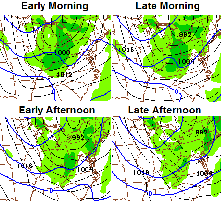
Lows by Friday morning will drop to 5 above to 5 below. Winds and clouds will begin to increase by the end of the day ahead of our next snow maker. This potent system will zip in here Friday night and Saturday with snow becoming likely. Check out the NAM…
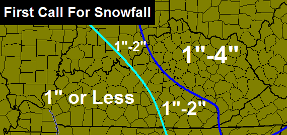
Accumulations are likely across the state with the highest totals in the central and east. Here’s a VERY early first call map…
Winds may gust to 40 mph at times on Saturday and that will create blowing snow and hazardous travel. Saturday looks ugly.
Sunday starts in the single digits and ends with temps running toward freezing on a gusty wind ahead of our next arctic front. This front plows in here Sunday night with a band of snow.
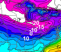
Temps behind this will drop like a rock. We’re likely to fall into the single digits by late Monday afternoon and may go below zero before the evening is finished. Temps by Tuesday morning may go well below zero. Here’s the GFS for that time…
Next week as a whole looks scary cold. Daily highs in the single digits with mornings below 0 are very, very possible. A prolonged period of this kind of cold can cause serious problems here.
I am traveling today and may not get to update the blog until late tonight. Follow me on twitter for my latest thoughts. Take care.

The NWS is calling for rain and temps near 40 on Sunday. Is that for real?
Seriously?
WKYT extended forecast published in today’s Herald-Leader also shows 40 for a high on Sunday. I don’t remember if it indicated rain or not.
Thanks Chris.
Need to get prepared. Heating fuel at 0. Been on list but they were filling up those who were out or close first. Now we are showing out. They called and said they were bringing some today but never showed. With the snow already on I am wondering if they can actually get the truck here before the next snow. If not gonna need a heat source so looking like some kerosene and electric heats.
Really not looking forward to this at all. Hope we get lucky and miss these temps.
Snowing big time in Cynthiana. Nothing on radar, but everything covered with a fresh layer of snow.
How come the NWS and local weather do not seem concerned. Lowest high temp for the next ten days is 17 and the lowest low is 1.
Seems like every channel has different temps for next week. I just hope it doesn’t get that cold here. I’m done with the cold and snow…bring on spring.
What do you want them to do? Warn you that it’s cold out? Common sense is becoming lost.
Bazinga – your comment is out-of-line and disrespectful. I believe CoalMinerD was simply pointing out that while Chris seems concerned about the cold, the NWS and local meterologists do not seem concerned. Please go to Chris’ post for Monday afternoon, January 13th – he addresses the type of comment you posted.
NWS is part of the machine that doesn’t believe in global warmin. They trust in misinformstion instead.
another nice little coating here in Lexington.
Ok I’m just an amateur here, but the NWS forecast that its going to warm up on Sunday and rain is laughable. With this much cold air in place and snowpack in order for it to rain would take a tremendous southern flow and gulf moisture. If that would be the case. it would have me worried about an ice storm not rain.
they are actually 4 degrees colder today for Sunday than they were yesterday for Sunday
at least for me
Read an interesting article about the warm ridge in California and their on going drought seems this could be the most severe drought since 1985, an analog year for this winter. Cool to see a solid relationship between overall weather patterns and the models.
The Sunday system is turning warmer for our area. The low is somewhat stronger than originally thought so the stronger the low is the more northerly track the low takes also takes the real good accumulating snow more to the north the weaker the low the more southerly route it takes and gives us more snow, models since about yesterday have all decided to go to a northerly track so this will allow a southerly wind to kick in. How warm it gets is yet to be seen even if it does get in the 40’s it won’t last long the artic front could careless.
Morning all and thanks Chris for the update. Saturday sounds like the kind if day to just stay inside and read or watch the Cats. Unfortunately it’s my day to work so guess I won’t be doing that. Today is going to be a cold one. Make sure to wrap up and wear those gloves when you have to be out! Have a safe trip home Chris, and everyone have a great day!
Wow that is some hellava cold weather heading in here next week. Not that it is not cold now, but below zero and single digits for three to five days is no fun. Hopefully the Sat. system is an over achiever and Sunday’s is no rain and all snow for the entire state.
Snow on Snow on Snow hasn’t happend in this area in a Long Long time. Stay warm all…..THINK RAIN!!!! Thanks for the update during your busy schedule CB……
Question
I’ve heard to pour rubbing alcohol into your drains is good to keep pipes from freezing……But how does that stop the actual water from freezing?
I can tell you this………My master bathroom is the only area in the house that has plumbing on the outside wall………and the day we stayed at 1 or 0 degrees all day and then went below zero that night, at around 4 am that morning I was up and taking a shower, and when I turned my water on at the sink in the bathroom, it made a funky noise. I was like OH NO…..but then it ran fine…….I can imagine an entire week of single digits and below zero causing pipes to freeze and bust…..what a mess that would be………
Alcohol has a much lower freezing point than water in the case of rubbing alcohol it’s -128F.
It would be better to use pool antifreeze or rv antifreeze in the p traps/drains. If you are really concerned about your water pipes freezing they have a heat wrap that you can apply. Will have to have access to the pipes and electrical outlet. Works we’ll for me.
I found an several interesting articles during the last arctic outbreak referring to the use of road salt… sodium or calcium chloride… It did the job on my tub drain once the outside air temp came up above 5 degrees…if you want more information on it, let me know.
Road salt or rock salt is very corrosive!!! Would not use on anything but asphalt.
Good point, and I did read that. Had to flush the drain several times with boiling water and cleaner afterwards.
I’d be surprised if your pipes under your sink are in the outside wall, with your/our neighborhood being all new since 2000 they should come up through the floor. Regardless, and especially if they are indeed in the wall, if you’re concerned keep your cabinet doors open so warm air can circulate in the cabinets when we have these brutal cold snaps.
I’m ok with this map. The Tuesday storm had Louisville in the 1-4″ range and we ended up with 4-6″ depending on what part of the city you lived. So, hopefully, this will be another over-performer!
It sure is nice to be the warm spot in the state this morning!!! Having had little to no snow on the ground does indeed have its advantages. If it means keeping temps here several degrees warmer, I’m glad to have no snow!
could be the front hasn’t made it your way as well 😉
Chris still saying temps make a run at freezing Sunday, so he is not so convinced as others are about the 40 something temps?
Hopefully the Sunday low comes in weaker and drops 100 or so miles to the South. Keeps us in the cold and snowy threat. Stronger the low the more North it will stay and we warm up with cold Rain.
Longer range models are showing for a warm up back to cold again for the mid/late February period. We need a bubba buster 10-12 inch snow to make this winter A real winner among us snow lovers.
yeah because 1.5 inches just isn’t going to cut it
Agreed. A southern storm with big snow would make this a winter to remember, for sure!
OK. Chris and Brian Goode are both saying temps next week will only range from negatives to single digits for several days, at least. That’s a consensus in my book. I am really concerned about the pipes. I have been dripping my faucets, but I want to know if there is something more/different that can be done. Any ideas?
I’m also afraid we could have major water main problems.
Does anyone anticipate a Wind Chill Warning being issues next week like it was around the first full week of January? Excuse my ignorance, I know very little about weather.
The path of the low for Sunday could change based on the snow pack. A lot of times the low follows along that path
Unfortunately, not in this case. If the low is forecast to get stronger, than it will take a more northerly path, but if weaker, it will take a more southerly path on us. The models have been trending stronger and stronger, meaning farther away from us. Snowpack does absolutely nothing in this case.
Snowpack will not influence the track of the system. The track of the system will be determined by how far south the upper trough drops.
MJ… do you care to offer some guidance on why there is currently such a disparity between forecasts for Sunday… I watched the Bastardi clip and understand most of it, just looking for additional input… and viewpoints! I love this stuff!
I’m not aware of what he said. Can you fill me in?
http://www.weatherbell.com/saturday-summary-january-18-2014
I’m pretty sure I didn’t make this comment, so there must be two of us!
You didn’t, I did. I’ll use a “y” at the end from now on
Endleswavz, OK, I watched it. I don’t have any real issues with it. Worst cold is yet to come, but the pattern will end up breaking down in early Feb. The Feb pattern will still be cold, but we’re likely to see more see-saw temp swings. My current thinking is that we’ll be -2 to -3 below normal for Feb with well above normal precipitation.
Wave 3 midday now has temps only reaching the low 30s Sunday with a chance of snow, no rain or 40 degree weather was mentioned!
Looks like NWS thinks lex gets 2-3 inches tomorrow night into Saturday.
You didn’t, and I will use a “Y” instead of an “I” from now on. And I read some where that there was some skepticism about the track of this low based on snow pack, I also know that the stronger the low, the more northerly track it will take.
meant to post that in a different spot. Sorry
Chris tweet says 4 plus inches of snow coming for some Friday/ Saturday period, WSW should be going up soon if this is the case!
To reach winter storm criteria by the numbers, an average of 4″ within a specified time period could constitute a WSW.
Unless I misread his comments or map, it appears 4″ was an upper limit, not an average.
Criteria is listed here. LMK’s is similar to JKL’s and PAH. IND/ILN criteria is a little higher, while OHX and MRX’s are lower.
http://www.crh.noaa.gov/lmk/?n=winterweather
Can you imagine if we have the snow that’s on the ground now, and the storm Saturday to add to what’s already on the ground…..ONLY for it to warm up enough Sunday and rain to melt it, then get bitterly cold. That would be CRAZY……….If it’s going to be cold I really hope that doesn’t happen…….Because I’m starting to get sick of these crazy temps ….hopefully there will be snow with them all the way to the final warm up whenever that happens..
Even if it gets into the 40s Saturday, I’m not seeing rain enough to get rid of all the snow, some METS are backing off those 40 degree temps today anyway, TWC and a few others are the warmest and not very reliable! Chris says low 30s!
Todd – not talking about the Saturday system……but the Sunday one…..I guess we will see what happens soon enough……
I’m still trying to wrap my mind around it being 7 degrees in the middle of the afternoon…….
I meant Sunday my bad!
And with the sun out no less. Thank God for heat.
If we do get above freezing for some time, it’d help melt the icy roads before the next cold snap comes through. FCPS has been missing school like crazy, not one day of school this whole week, and potentially 2-4 more days off next week. At this pace, schools will be open ’till late June!
Late 1970s when I was in school we missed 6 straight weeks, I think that then governor Carrol pardoned alot of those days so we could still have a decent summer break!
A good snowfall with these kinds of temps.
Then I can tell my grand kids this is how it was
Way back when. Or this is how it was in the old days
Haha I’m talking about the 70s way back when.
Did MET surfing at lunch to see temp differences for sunday here’s what I saw:
WKYT – high 33
18 news – high 36
36 news – high 33
TWC – high 41
WLKY – high 46? (LouIsville)
Wave 3 – high 34 ( Louisville)
based on this low 30s seem to be the consensus at this time!
According to my thoughts and viewing others, I think mid 30s is likely, possibly upper 30s near 40 in Louisville.
Probably a good call, these number will go up or down a few degrees in the next 24 hours or so, If we get a few inches more snow before Sunday I think a downward trend will happen?
I think it depends on how much snow falls in southern ky, because on sunday warm air advection from the southwest. It’ll cool down the air with a good snowpack enough for the temps not to warm as much in central ky.
It wont snow enough down here it hasnt yet why would it change
Travel Safe today Chris and stay warm!!! 🙂
I recently mentioned that College Station TX (home of Texas A&M) doesn’t get much winter wx. Well, they and other parts of south Texas are about to receive some. Unfortunately for them, an ice storm could be part of the equation 🙁 .
It’s not often you see a Winter Storm Warning in effect on the Gulf Coast (includes Houston and Galveston TX).
http://www.srh.noaa.gov/hgx/
BTW, currently 18 in Nashville TN. Looked up Minneapolis/St Paul where Chris Bailey is, currently -8 there.
Whoops, my bad. I’m “TennMark”
The latest NAM has lou,f.fort,&lex in the 2-4 inch range.
Could you provide a link to that map?
go to Brian goode Facebook page
wave 3 weather
I will paraphrase he likes the nam ideal on how the snow totals will fall.
Btw are u brian goode.lol
Naw, I’m just Brian Sorta-Okay!
12z NAM
http://grib2.com/gis-snow-overlays3.php3?BASEHR=12Z&STATIONID=JKL
I wish you would have posted about 2 minutes earlier. it would have saved me sometime from the keyboard.
anyway good job getting the info out to the public.
The last little burst of snow puts me to about 8 inches in Lawrenceburg for the season. Should be over 10 inches by Saturday. The real question–how cold does it get tonight? I had -9 on Wednesday. I haven’t seen it -10 or lower here in 18 years.