Good Monday, folks. Our week is starting off on a soggy note across the commonwealth as rounds of showers and storms rumble through. The action we are seeing today is all part of a very active weather pattern that looks to continue through much of the spring. Moral of the story… I don’t see a shortage of rain and storm chances ahead.
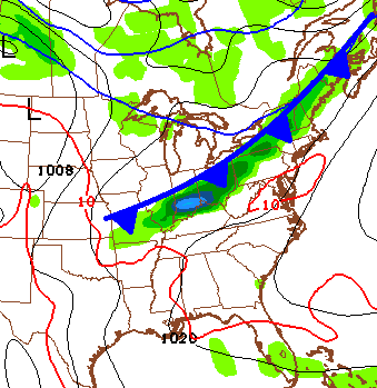
Today’s action is along an area of low pressure working in from the south. This will lift across the state this afternoon and we are likely to fire up a few strong storms. These could be hail and high wind producers to go along with heavy rain.
Let’s track the day…

Today’s Risk Area

Current Watches

Possible Watch Areas 
That low will lift to the north this evening and that allows for a break in the action. The upper level low will then swing in on Tuesday and that could deliver more hail producing showers and thunderstorms. Winds will be very gusty as chilly air moves in.
Temps will rebound toward 70 for Thursday and Friday. That’s when a weak front settles in from the northwest and brings the next shot of showers and storms…
 Temps will then crank up over the weekend and could make a run at 80 degrees on a strong southwesterly wind. This warm air will meet much colder air pushing south across the northern part of the country by late this weekend into early next week…
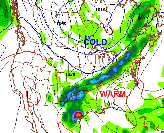 That could produce some big storms and heavy rain across our region. There is even a hint of a taste of winter following that up for a day or two.
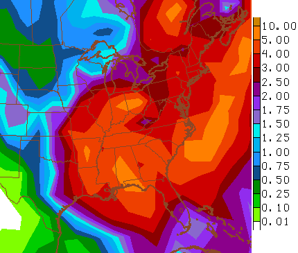
I mentioned this is part of a stormy pattern that has a lot of rain with it. Check out the 2 week rain forecast from the GFS…
 Enjoy your Monday and take care.

Interesting to see the latest GFS shows some light snow glancing over north KY with the system early next week.
I know this is a little of topic but I saw this weekend here in charleston we cracked the top 5 for snowiest march and have had over 55 inches of snow. That’s impressive.
Off
“April showers bring May flowers”
Talk about a bust of a forecast that I will take. Yesterday everybody said that by this morning, there would be heavy rain everywhere you look…at least in the Cincinnati area. Got up this morning and it was dry as a bone and thanks for some schools still having Spring Break my commute into work was a breeze.
Go Cats!!!
That’s actually not a good sign. Here in Lexington some sun is trying to poke out of the clouds meaning more instability, which could fuel stronger storms. It almost seems like we’re in a type of unexpected dry slot waiting to fill in soon. SPC already has a slight risk stretching from Central and EKY, into southern Ohio which is where the dry slot is at this morning.
Yes, severe wx for us was fairly low on the cards; the severe stuff was expected to stay well to our south and southeast. But it just goes to show that there are elements of art as well as incomplete scientific knowledge in forecasting wx.
Although what may suppress the severe threat are the temperatures. Not rising much at all and staying in the 50s.
Some areas still got some good rains. The KY Mesonet shows up to about 1.25 inches have fallen in parts of far western KY.
Cincinnati now reporting heavy rains via a thunderstorm!
Perhaps the same batch of moisture that produced t-storms in Louisville a few hours ago.
All day yesterday that heavy rain was supposed to be hitting around the morning commute but that was a no-show when the sun rose.
I’ll take any victory I can get when it comes to weather.
Now to see if any storms get fired up across Kentucky proper…
Yea, last night the radar showed what looked like a good swath of rain headed into KY. There were some decent overnight downpours in TN, including here in Nashville. But in a bit of a surprise, most of the heavier rains ended up staying in TN.
We (Nashville) just had a brief heavy shower (you can see the line on radar, it formed from Nashville to north of Bowling Green), we now have bits of sunshine. As poster ‘Israel’ touched on earlier, interesting if this sun will fuel instability later on. The Storm Prediction Center updates its severe storm outlook in about an hour from now. As Chris Bailey mentioned, there was small twister threat for central/east KY later today.
BTW, as always, thanks Chris for keeping us informed!
Thick clouds in frankfort not going anywhere anytime soon, very little storm chance in this area, just another grey cool day here!
same with most places things are not panning out as some expected.
SPC now has a Mesoscale Discussion for a possible watch (perhaps tornado watch) for central/east KY and southern OH.
A couple lines of t-storms popping up now, one east of Bowling Green and the other south of Cincinnati.
Just imagine if this would’ve been the middle of winter and a snow system. QPF forecasts from every met ranged from 0.75 to 1.5 for CKY and SKY, that would be equivalent to 9-18″ of snow and we would’ve only gotten an inch or two. On the other hand, it has gotten VERY windy quickly! Wind speeds constantly gusting to 35+mph and several 40+!
Had a few short heavy rain showers here today.The wind is just awful since just before dark.Not really letting up at all.With all these swaying trees around I am a bit nervous tonight.Sure hope the winds die down soon.Howling around the corners like there is a blizzard going on.
Just had a 43mph gust at my house
Nice line of t-storms approaching Ashland KY.
But at least the SPC no longer has a slight risk of severe wx for our area.
shouldn’t have been put out to begin with
The farmers almanac predicts a wet stormy spring.then some hot rainy weather in the summer.gonna have a late garden I guess….oh well…could be worse.plenty of rain in aAlexandria Kentucky/windy