Good Friday to one and all. We have a taste of summer air blowing into town for the weekend, but it may come with a bit of a price. A few thunderstorms will be around before temps take off and a big temp plunge is on the way for next week.
A cold front is crossing into the region today and this is touching off scattered showers and thunderstorms. This is not a washout of a day, but you will need to keep the umbrella around to be safe. Temps will be a little tricky because of the scattered nature of the storms.
Areas without storms will see temps nearing 70. Those with storms will be closer to 60 degrees. Track away…
Current temperatures


Temps this weekend will take off and will likely flirt with 80 degrees before all is said and done. Winds will be rather gusty and there is still the smallest chance for a stray thunderstorm popping up.
Most of the showers and thunderstorms will hold off until a strong front arrives later Monday. That will bring some heavy rain and the potential for some strong boomers. Will we see a wave of low pressure developing along the southern end of this front as it slides up the east coast? Many models have been hinting at that of late and the European Model advertises this well…
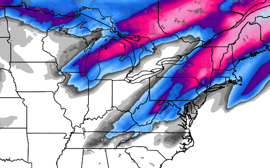
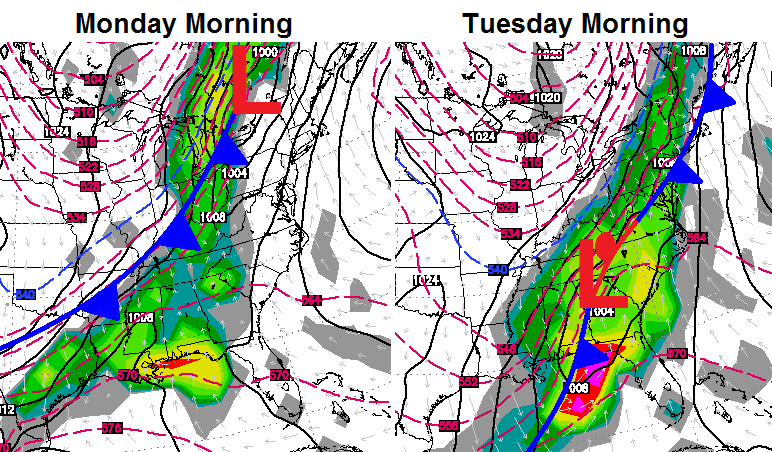 The European Model continues to produce a swatch of winter weather with that second system on Tuesday…
Ummmm… No, thanks! We will have to wait and see if there is any truth to that run. Regardless… temps will warm quickly by the end of next week.
Enjoy your Friday and take care.

Not that I am complaining, but this seems the wimpiest spring so far for bad storms. If hurricane season is wimpy and we get another colder trending winter- I calling in the start of a mini ice age.
Hey, if the media can out of context data and short term trends for their agenda- I can too! 🙂
My reaction to that last pic……
ugghlth.
There is still a possibility for a hard freeze next week. In Lexington, the average last day for a hard freeze (<29°) is on April 2, and for the last freeze (<33°) is on April 14. Cover up those fragile plants if we do get that low Tuesday night.
On the other hand, we're making a record for the latest first recorded EF-3 or higher tornado of the season. We have broken the last record on March 31 and still going. And of course, this is a good record to break and would be welcome anytime. I'm still wondering when the bottom is gonna fall out and severe weather season really starts.
Consistant nice weather is never here until after derby so this is about the normal pattern of most years I’ve lived in KY!
Todd, I hope you get your rainfall this year and it doesn’t keep missing you even in the midst of a wet summer like last year, that’s if this summer is wet.
I fully expect my area of frankfort to be dry this summer, two wet summers are rare in my hood!
This is the official NWS forecast for my location for Tuesday!
A chance of rain and snow showers. Partly sunny, with a high near 51. Chance of precipitation is 30%.
Snow flakes on tax day? Would be fitting, i guess…
Is this line of rain moving through at noon the rain for the day, or will there be more popping up later? Got big plans for this evening!
This is more than just a scattered showers. It is thundering and lightning here on the Ashland/Catlettsburg line. I see very little rain!! I was expecting rain but not all this other stuff. When I look at the radar all I see is green which to me indicates just some rain. I wasn’t prepared for all this lightning. Ok here comes the rain. It was just alittle late. I don’t mind thunder but lightning scares me to death. Ok my vent for the day. Hope everyone stays safe!!!!
Looks like dogwood and red bud winter may both hit early week
Beautiful several days an counting
Here on the farm throw a few cool whimsy
Days next week we can handle it sweet sweet spring chickens