Good Sunday, folks. This is about as nice of a weekend as you will ever find here in the bluegrass state. Temps around 80 and sunny skies have teamed up to throw a summer tease our way. While it feels like summer now… Old Man Winter fights back for a few hours this week.
Highs today will likely hit the lower 80s for most of the state. Winds will be rather gusty as clouds increase from west to east. These clouds are ahead of a powerful cold front that swings in here on Monday. Rounds of showers and thunderstorms develop tonight in the west and will roll eastward tomorrow.
A few of the storms could be strong or severe as we transition from summer to winter…
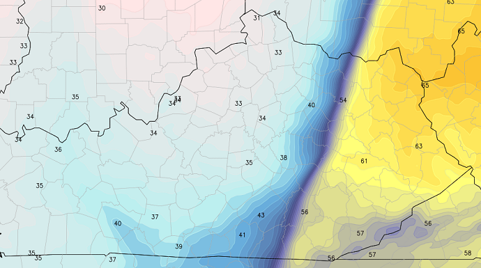
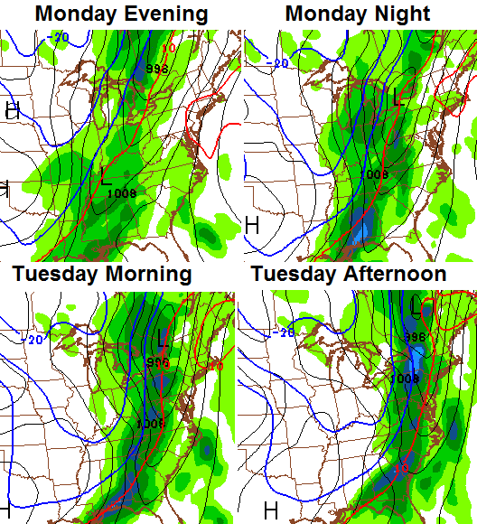 The temperature drop behind this front will be dramatic. Readings will drop 30 degrees in an hour or two. Check out the Hi-Res NAM numbers as the front slides in Monday night…
With temps heading toward freezing and lingering moisture around, a period of light snow and flurries will be possible into early Tuesday. Some of the models suggest a grassy accumulation…
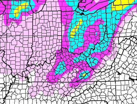 That it likely a bit too aggressive, but I can’t rule it out. If that produces any flakes across the state, it would mark the 7th straight month it has snowed in Kentucky. While I haven’t had a chance to do the research, I can’t imagine that has happened more than a handful of times in recorded history.
Highs Tuesday will stay in the 40s with lows in the upper 20s for Wednesday morning.
Temps will rebound into the 60s by Thursday into Friday. That’s when another rain maker rolls in with a drop in temps for Easter weekend…
 There’s some ugly in this pattern through April and into May.
Enjoy your nice Sunday and take care.

Wow this is gonna be one huge temp swing. I’m certainly thinking the ground will be too warm for much accumulation though.
Chris I thought we were through seeing snow flskes?
So define ugly. You use the word ugly often. What exactly does it mean? Does it simply mean weather that is not blue sky and eighty degrees? Or is it more nuanced? Does it refer to stormy weather? It’s a sincere question. Since mid-February ugly has popped up more and more. It just seems a bit of a subjective adjective clouding up impartial data in a scientific field. It also seems like it caters to one specific audience and reinforces weather stereotypes. Anyway. If it’s not too much trouble, define ugly for me. Thanks, and please don’t kick me off your blog.
As far as I know being on this blog for a year and a half, when he says ugly in the winter, it means ice. When we get into spring he refers to weather that’s damp and cool/cold, cloudy obviously. I don’t think I have heard him say ugly in the summer before unless it could be because of flooding or so? Not so sure but this is as far as I know.
I was wondering if there would be any ugly summer days. High heat, high humidity-type thing. It is interesting how entrenched the idea of good and bad weather is.
I guess that could be another one but I don’t think he a*ssociates that with ugly.
“There is no such thing as bad weather, just different types of good weather.”
Not wanting to jinx us, but this could end up being the wimpiest storm season in recollection for this area. Bubbacast is already calling for a similar winter to the last. We are at the footsteps of a mini ice age. Brrrr! 😉 🙂
Predicting a Bubba Buster this winter? I hate how we had such a cold and pretty snowy winter but the systems with the potential for significant amounts of snow busted.
I am not looking forward to another below average snow fall season and below normal temps if its a repeat of last.
First yard mowing of the season today, and the yard work begins 🙁
thanks Chris! Yeah, don’t mean to sound “ugly” but that big temp swing is mud ugly!
Hats off to the UK baseball team-off to a great start this year.
Speaking of “jinx”… 😉
I have already mowed once. With my allergies I dont look forward to spring and summer. Hopefully it will be nice and cool. I was disappointed in the winter we had, cold but not alot of snow.
5″was the biggest one day total we had in Richmond.
After this beautiful dry weekend, I just say no to snow, and of course , no to cold!
Cold you have had your run, see ya next year with the next wildcats basketball run!