Good Monday, friends and neighbors. Our summer weekend is now in the rear-view mirror and we are staring at something ugly through the windshield. Winter is ready to blow back into the bluegrass state and deliver a does of ugly stuff over the next few days.
Today is the big day of change as a monster cold front pushes across the state. Widespread showers and thunderstorms will be noted ahead of this front and a few of the storms could be strong. Winds will be very gusty as temps surge toward the 70s ahead of the boundary. Watch how quickly the bottom falls out…
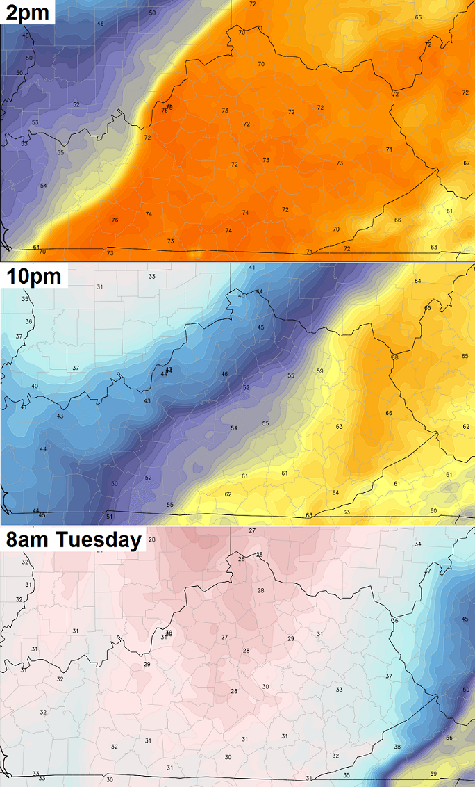 That is just a wild drop that will be accompanied by winds gusting to 40mph. The cold air looks to catch the back of the precipitation shield and switch it over to a period of light snow and flurries late tonight and Tuesday morning…
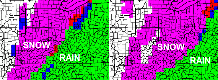 A grassy accumulation is possible across much of central and eastern Kentucky. I’ve seen situations like this put down a narrow band of heavier snow. That will be something to watch for as it’s happening.
Highs Tuesday may not get out of the 40-45 degree range with a wind chill in the low 30s. Mid 20s are possible by Wednesday morning and that could result in a hard freeze.
We look to rebound into the 60s by Thursday with another rain maker lurking for Friday. The big Eastern weekend looks cooler than normal with the chance for a shower or two hanging on.
Let’s track today’s big changes…
Current temperatures

Winds


Enjoy your Monday and take care.

No big deal. Typical April weather.
Well thats not to bad.I seem to recall having snow as late as May.
Really don’t want any more snow for awhile though.Sure hope there are no bad storms as it makes it way across Ky.Certainly not looking forward to all the wind.I suppose it won’t be good for the things that are growing right now.My tulips and jonquils may lose their pretty blooms.
Hanging in here for one more round I guess since I don’t like extreme heat either.Seems like it has been such a long,drawn out winter.
We’ll be back in the 60s and 70s a few days after this storm. I have an animation of the cold front progression (temps) on my blog if anyone wants to see that.
Unfortunately, most fruit trees have started to bloom. Local apple orchards must be sick to see 20’s back in the forecast.
For perspective, the record for latest snow is May 24 for Lexington. Anyone know the average date of the last snow?
Average last dates for snow in Lexington…
Last inch: February 28
Last measurable: March 22
Last trace: April 7
So if we do get snow, it is late in the season. If we do get measurable snow, that is quite rare in mid April, usually the last measurable snow is around mid to late March.
Thanks. We’ll see what, if anything, we get. Looks like as it currently stands March 25 was our last measurable snow and March 29 last trace.
The sustained wind is very bad.I think its higher than some of the sites are saying.Maybe its because I live on a hill.Wind makes me nervous with all these swaying trees along the fence lines.
Ryan,I checked your page.I like it.
jdthom,I haven’t lived in Ky long enough to see a May snowfall personally.I do recall reading about it at some point.I sure hope we don’t have a May snowfall this year but the way the weather situation has been it sure wouldn’t surprise me.
I am really hoping these winds die down but its not likely till late today.{[:^)
“There is no such thing as bad weather, just different kinds of good weather.”
Just think about that for a second…
We’re in a freeze watch, here is what the NWS has to say…REGIONAL AGRICULTURAL EXPERTS HAVE INDICATED THAT THE GROWING SEASON HAS PROGRESSED FAR ENOUGH THAT A HARD FREEZE WOULD BE IMPACTFUL TO SPRING VEGETATION. TEMPERATURES…TEMPERATURES LATE TUESDAY NIGHT AND WEDNESDAY MORNING COULD DROP INTO THE MID AND UPPER 20S. A HARD FREEZE IS LOOKING INCREASINGLY LIKELY DURING THIS TIME…
Impressive how far south this cold could go. Freeze watches/warnings almost to Austin TX.
So much for hoping for a good fruit crop this year, nasty cold spell always ruins the party in KY! Hoping for clouds and wind Tuesday nite???
I know this is a cpl weeks away but would appreciate any info on the weather for Laurel County May 17th. I’m planning a party for the outdoors and was very curious about the weather & I know CB is the one to ask. Thanks….
SHANKS they can redict weather 3 days out much less a month, lord what a question
This coming from someone who predicts “old skool a comin” three days out then changes his mind to “move along folks nothing to see here” the day before.
This
Nashville TN hit 82 yesterday.
Now the cold front about to enter western parts of KY & TN. Parts of Missouri and Arkansas are already down into the 30s 🙁 .
Dry as a bone mowed 2 achers
Beautiful spring day
Looking at radar trends, the snow chance looks small and hopefully the cold air for Tuesday nite is over done by the models!
Maybe it will stay above freezing.I would hate to see a lot of plant life destroyed.I suppose its not that unusual for it to be very cool around Easter.