Good Wednesday to one and all. After snow and a hard freeze in the middle of April, there is only one way to go from here. Temps will begin to warm out there today and will really ramp up in the coming days. While this isn’t a very warm pattern, it’s not too bad going forward.
Highs today will rebound into the mid and upper 50s for much of the state under a mostly sunny sky. Thursday will see readings back into the mid and upper 60s and that’s about normal for this time of year.
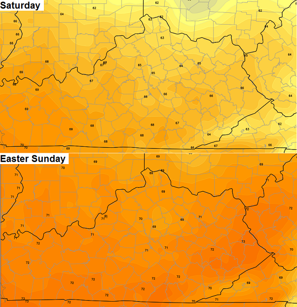
Friday will see a weak cold front dropping in from the northwest. This boundary will deliver the threat for a scattered shower or thunderstorm. With that system looking weaker, the Easter Weekend weather is looking better. Check out the highs from the European Model…
There could be another weak system working in for early next week with another threat for scattered showers and thunderstorms. Most of the models are trying to pop a warm pattern for the middle and end of next week…
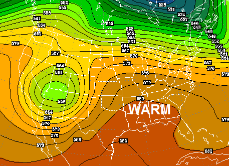
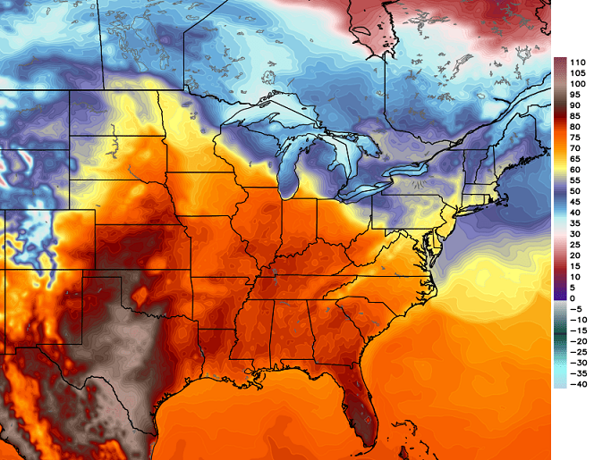
That’s what the GFS is seeing. The European Model is also showing some pretty toasty temps…
 Enjoy the day and take care.

Thanks CB.
after the last couple of days, I think we will take a high of 65. that sounds right about at the perfect temp for spring anyway. thanks for keeping us updated on the snow and hard freeze, Chris. I was able to get all my stuff covered and brought in.
Minimal frost damage in my area of frankfort, thankful not as cold as I thought at my house, 26 and very little frost on the ground this morning!
But were in a frost advisory tonight, forecast tonight is around 33°, we’ll see if we get more or less frost tonight than last night.
Places like Louisville, Bowling Green and Nashville will be somewhat of a close call. But warmer to the west.
BTW, Nashville had a trace of snow yesterday morning; the first snow Nashville has ever on any April 15 since official records started in 1884!
Nashville’s latest trace snow is May 19 1894.
Got my tenders into the greenhouse.. WITH a small heater it dropped to “only” 32F so it was a close call! Outside we were 20F overnight.. the pear and plum blossoms are goners..
On this date in 1998 was a tornado outbreak which included several F3 tornadoes in Kentucky, the well publicized downtown Nashville tornado, the so-called “Forgotten F5” in south-central TN, a tornado at Cleveland TN (very near where I lived as a teenager) as well as a very costly hail storm in Bowling Green.
NWS Nashville
http://www.srh.noaa.gov/ohx/?n=19980416
NWS Louisville
http://www.crh.noaa.gov/images/lmk/pdf/April_16_1998_Poster.pdf
The Cleveland TN twister caused one fatality and kind of shocked me out of my teen funk in downplaying severe wx. It’s partly what motivated me to learn more about weather and to become a SkyWarn storm spotter. This and watching endless replays of the Nashville tornado hitting downtown.
I arrived in Bowling Green during the fall of 2004 to attend WKU. But even at this time there were still a large number of “hail cars” (vehicles covered with huge dents) still on the roads 😉 .
Mark, I’ll have to check but I think my aunt (who lives in Gallatin) bought one of those above ground storm shelters due to that tornado your talking about.
It could have been one of the 1998 twisters.
Also, Gallatin itself had an F3 tornado on April 7 2006.
In 1998, I was a teenager near Cleveland TN. The scary thing about the Cleveland twister (only an F1, but still bad enough) is not only that it happened near me, we were not aware of it until long after the fact.
My future wife was herself a teen in 1998 Bowling Green. The cars were ok as they by luck were sheltered. But among other things, major roof repairs were needed to stop the leaks that resulted from the huge hail stones.
Hit 25 in Carrie with minimal frost on the ground this morning, nice day today, nice jacket weather