Good Friday, everyone. I’ve been hawking a very busy pattern for a while and that pattern is just about upon us. A surge of summer air this weekend will bring rounds of showers and storms our way for early next week. That’s a setup that could lead to strong and severe thunderstorms.
Speaking of showers and storms… we have a few of those out there early today. This action will be across central and eastern Kentucky early today, but will push out of the state in the first few hours of the afternoon. Skies will become sunny with temps ranging from the upper 60s to low 70s.
Follow the action…
Current temperatures


The weekend weather looks amazing. Highs on Saturday will range from the upper 70s to low 80s and then into the low 80s for Sunday. Skies will be partly sunny both days. Some late day showers and storms will be possible Sunday and this will begin our thunderstorm train.
Rounds of thunderstorms look to sweep across the state from Monday through Wednesday. Check it out…
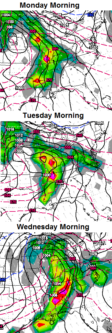 In addition to the severe weather threat… repeat rounds of heavy rain could cause some issues.
The huge upper level low coming in behind this stormy pattern is still on track. Areas that get under this low will see the ugliest of the weather conditions with damp and chilly stuff lingering for days. Check out how massive this low looks to be…
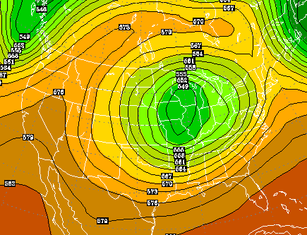
That’s a lot of ugly for much of the country for the second half of next week. Here’s hoping it’s all gone by Derby weekend, but I have my doubts.
Have a great day and take care.

Thanks Chris!
Seems like it’s cool and damp here in knott co every year for the trail ride/derby week. Dogwood winter
Thanks Chris. We’ve had a pretty good storm here this morning, with lots of streaking lightning and thunder, and heavy rain. Right now, it is pretty calm although still cloudy. Radar looks like we have another round of rain yest to come before we are done with it until Sunday night or Monday….so, everyone get out and enjoy the next two days and a half! Chris, will be checking in frequently on the blog to see your thoughts as the next week unfolds. Happy Friday, everyone! Thanks again Chris for all you do.
You can see the deformation comma so typical with many winter storms forming on the radar.
I love it when thunder is my alarm clock, my favorite sound to wake up to!
Yeah. I was boomed from bed this morning too.
Its 2:12 in the afternoon here and just had a windy light shower come through harlan chris.
Back edge of clouds seen to be hung up around Louisville area! Bring on that sun!
We had very little sunshine today.Seemed overcast for most the day and very windy.It has calmed a lot but still blowing somewhat.Didn’t rain a whole lot but gave every thing a rather nice soaking.Did get a bit of yard work done this afternoon once the showers finally moved out.The air had an almost chilly feel to it.Not going to complain because that beats roasting as far as I am concerned.Not really looking forward to a stormy week.Sure hope it won’t get to bad.