Good Sunday, everyone. It’s a much calmer day across the Commonwealth as our potent storm moves away. Even with a calm few days ahead, the overall pattern remains very active as the trend is finally pointing toward winter across much of the country, including here in Kentucky.
This is a transition week toward that winter pattern, with the main change showing up next weekend into the following week.
Let’s begin with where we are today and roll forward. Clouds will linger into part of the day, especially across the north and there could be a couple of early day showers…

Highs stay in the 40s north and 50s south.
Monday is another calm and pleasant day, but Tuesday could bring some additional rain into southeastern Kentucky. The NAM is most aggressive with this…
 Another system crosses the region Wednesday and brings a few showers with colder air coming in behind that for Thursday. The main shot of cold arrives behind a much bigger storm on the weekend…
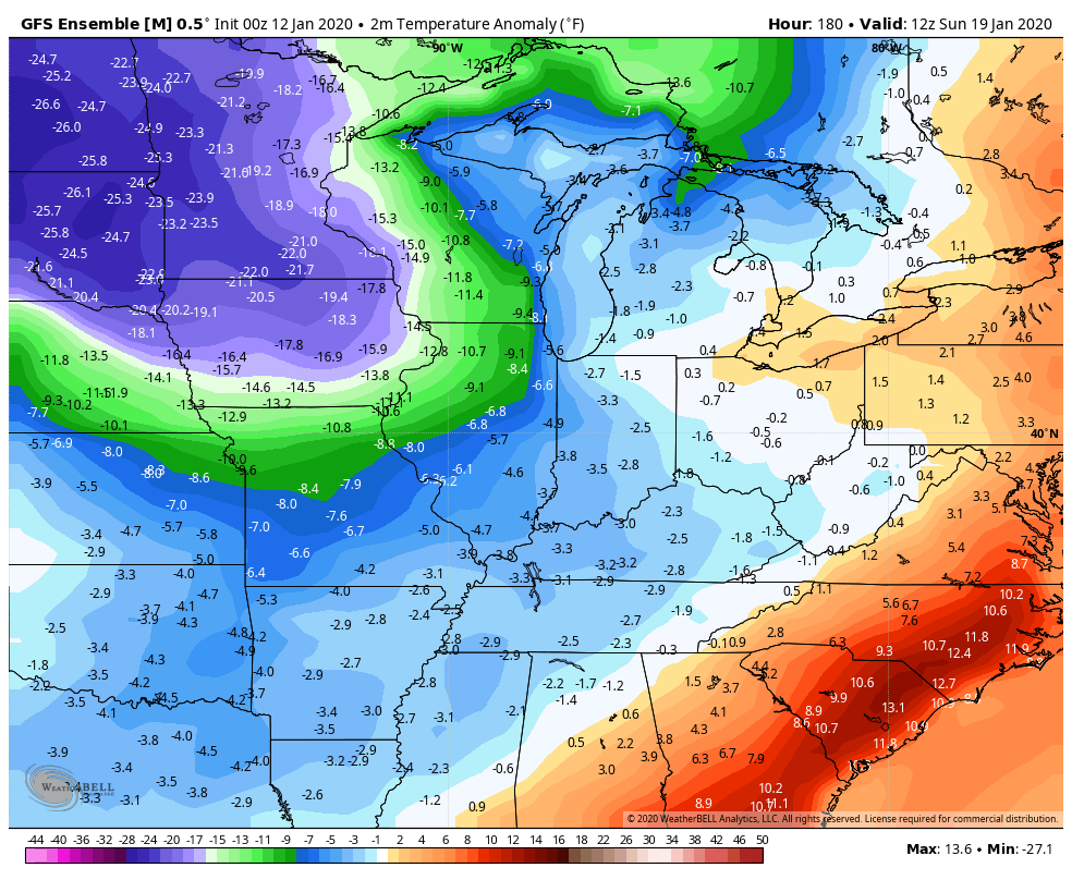
 With a ridge going up in the western US, that allows for cold air to take control of the eastern half of the country. Check out the temperature departures from normal on the GFS Ensembles…
 I will get more into that with updates later today. Have a great Sunday and take care.

Lots of wind yesterday afternoon along with a line of very heavy rain along with some wind damage for some folks in and around my area. According to the Mesonet my county of Taylor recorded 1.05 inches of rain, but more fell in my backyard in a very short time like around 3.00 inches plus. It is odd that lightning and thunder were at a minimum. Also noted some cloud rotation before that second squall line went through. I sure wish that we would get in on the snow action like the folks to our north and west. We need a Winter time hurricane along the east coast to change the over all pattern back to our four seasons, but it may take more than that, as that southeast ridge is really strong due to a very warm Atlantic ocean and an ENSO neutral cycle that is predicted by NOAA to last well into next Summer ? Forgot, the temperature yesterday in my backyard was 75 degrees plus with the heavy cloud cover and rain most of the day. Never have seen this in January ever ! I am going to agree with Jimbo that this is our new norm from now on in Kentucky and not just a weather cycle. Weather cycles just don’t last this long at lease they didn’t use to. Anyway, snow lovers and non snow lovers have bless and quiet Sunday.
The weekend storm, while still packing a decent punch (north winds gusted around 40 MPH Saturday), was an underperformer here in the Chicago area in terms of rain and snow.
In the SW suburbs, we got about 1.50 inches of rain Friday night into Saturday (3 to 4 inches had been predicted on Friday) and less than a half-inch of snow Saturday night, mixed with a little freezing drizzle. O’Hare Airport did get 2 inches of snow, though.
We’re up to a mere 7.5 inches of snow for the season, while O’Hare has a little more, 12.9 inches.
Illinois Mike, are you near Cicero?
I’m near Joliet and Romeoville in the SW suburbs, about 30 miles from Cicero (where my late Grandma used to live).
Interesting adventure yesterday for my family and I as we visited Bowling Green. Glad we traveled Friday evening ahead of the worst weather; still gusty on the drive up but nothing like yesterday. A non-thunderstorm wind gust of 63 mph was reported at Western Kentucky University yesterday morning before the t-storm line even arrived. By afternoon, saw a couple of large tree limbs from seemingly healthy trees on the ground and in at least one case a whole tree was toppled.
Oh, my in-laws lost power as well…thank goodness for their generator. After Bowling Green’s disastrous 1994 ice storm, my in-laws didn’t want to go through days of no power/heat again (my wife experienced the 94 storm as a girl).
Pouring rain and strong gusts on the way back home last night. In my neighborhood, only a few dead limbs on the ground. Some of our clocks/appliances were blinking so at least a brief power flicker, but our neighbor said no long term outages.
Looks like no loss of life so far in KY and TN. Unfortunately, that was not the case in other states. NWS staff will be checking out Cadiz KY for a possible tornado there. As mentioned on this blog earlier, a mobile home was flipped near Richmond KY; while likely straight line winds, NWS is checking that out as well. No mention of NWS Nashville doing any surveys as of now, but wouldn’t be surprised if some happen. A garage in D-i-c-k-s-o-n County TN was destroyed even if the (separate) house was left undamaged.
Very warm, stormy January weather is by no means limited to recent years/decades. On this day (January 12) in weather history in 1890 was a tornado outbreak. St Louis and other towns in Missouri were affected, but the most violent, deadly tornado that day was an F4 which leveled much of Clinton KY.
Even though January twisters are not unheard of for our area, more violent winter tornadoes are far less common. Indeed, this F4 at Clinton is one of only two January F4s in Kentucky’s recorded history (no January EF4s in Kentucky have happened to date, the Enhanced Fujita scale replaced the original Fujita scale in 2007). Maybe no big surprise that over the last 130 years or so, the small handful of January/February F4s in Kentucky and Tennessee have occurred in the western areas of both states. The lower elevations near the Mississippi River Valley may provide a bit more warmth and thus a bit more lift, moisture and instability to fuel any tornadic thunderstorms. Add shear (both speed shear and vertical shear) and you may have a good formula for tornadoes. In this case, January 12 1890 saw conditions in Missouri/Kentucky that are much more typical of the spring months.
For more,
https://kyweathercenter.com/?p=17151#comment-174614
Here in Southern Ohio we had wind gusts of 60 mph and two squall lines of high winds.
But I loved every minute of that warm weather we had. I had 77 degrees at one on my thermometer. I take that any day over 20 degrees and snow. Even with the wind.
Folks, temp departure from which normal is the question ? Don’t fall for it snowlovers…. fork is already in, from now to winters to come.
I’m admittedly a layman, but I remain hesitant to say this is “the new normal” regarding ANY weather pattern in the world and I’m certainly not a proponent of the “climate change” conversation.
With that said, we can’t really make any conclusions on our climate locally and it’s pattern when we have only 120 or so yrs of weather data and I venture to say much of that is not entirely reliable due to a lack of technology and data.
And with that said, I just wish we could have one big snow….just one.
Look up melting permafrost.
The fact that you think we only have 120 years of climate data is probably the reason you aren’t a proponent of climate change. If you understood it, you would be.
There is a lot going on in the world over the past 48 hours. Super warm and stormy over half of the US to a strong earthquake in Puerto Rico to a decent volcano eruption in the Philippines.
Yesterday’s official high at Charleston was 80. The only 80 ever recorded at that site in January. I don’t think it is the last 80 we will see in January, maybe no more this year. But with the current trend. I think there will be more to come. Yesterday there was frogs chirping, Easter lilies popping out and people mowing their lawns, ahh Winter in the Ohio Valley. Who needs Florida? South Carolina?
My new fronds on my palms are fully opened now with a second spear starting on my Windmill!
Already almost 60 in Harlan today, and the next 3 days look to approach between 65 and 70 until average cold returns by Friday.
80 is incredible, but like you, I think it is just the beginning. I have already posted before on this, but I take a different type of stance on Global Warming and do believe it but believe it ties in with the Bible and it clearly mentions that man would destroy themselves in the last days. People can disagree with me and that is fine but I am one that thinks God and science are tied together and I am not here to preach on a weather forum, so I will leave it at that.
Will we ever get snow this winter, or is it safe to say it’s just a repeat of last winter?
Repeat, repeat, repeat essentially, there will be anomalies in coming winters, except reverse from what it used it to be. The anomalies used to be 60 to 70 degree days, the anomalies will now be 15 to 20 degree days
Highs in the 60s and 70s have been very common in SE KY for many years now with the frequency of days around average (mid 40s in Dec to Jan, low 50s in Feb) becoming far less consistent.
Since the start of the 21st century days that remain below freezing have become increasingly rare in my area. I have recorded numerous days in October in the 90’s and a 100 one time in 2007. A 90 in February or March will not surprise me in the least. I am still laughing at the locals here talking about the strong cold front bringing Winter like temps this week. I have mid 50’s to mid 60’s for the next week. I suppose 55 is cold compared to 80 but it is still 20 degrees above normal.
Nothing certain to say we will have a complete repeat of last year, but it has been very similar to last year through Jan 12th, except EVEN WARMER, LITTLE LESS WET.
Some of you are saying this going to be our new near normal winter climate that’s hogwash. This type of weather winter that we have been experiencing last year and so far this winter has happened before. The typing must be from young folks that don’t understand the cycle of mother nature. Have a good day!
You are incorrect…. have a good day! Might take a moment to look at what is going on around you haha
Jim B , you are absol correct!
*absolutely, not absol… Crazy phone