Good Wednesday, everyone. We are tracking a cold front into the bluegrass state and this will continue our trend for isolated showers and storms today. What’s coming behind this boundary is nothing short of awesome and it arrives just in time for Independence Day.
Let’s start with today and roll forward. Scattered showers and storms will continue with periods of sunshine in between. Highs will still be toasty with mid and upper 80s for many.

Current temperatures

The front slowly presses to our east on Thursday and will help steer Arthur toward the Carolinas and then just off the east coast toward New England.
A few clouds with a shower or spotty storm is still possible around here Thursday. The dry and cool air then settles in and takes control into the weekend.
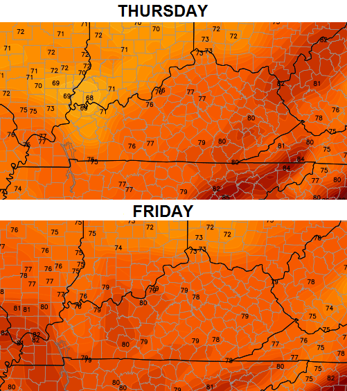
Check out the forecast highs…
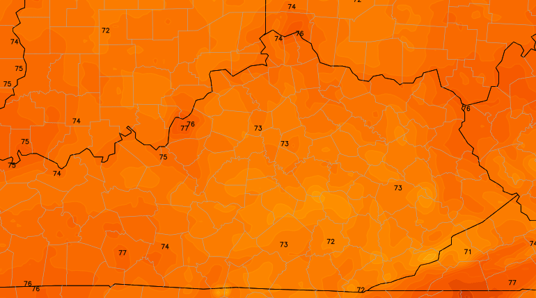
The Hi-Res NAM is even cooler with highs on Thursday…
The lows from the GFS are even cooler than before. While these are probably overdone, they are pretty awesome to see…
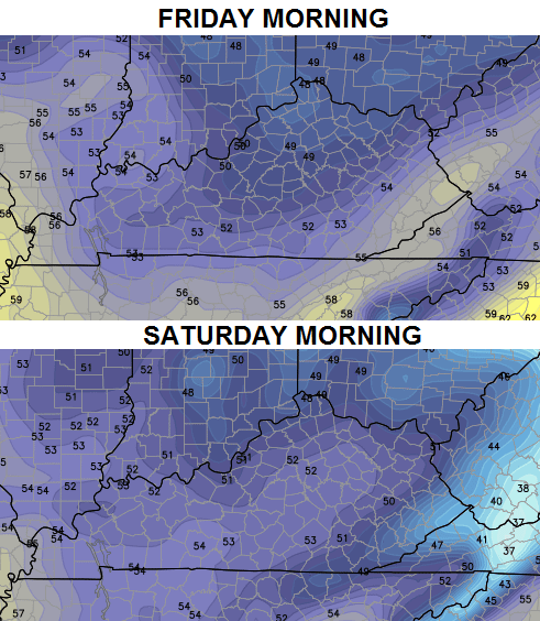 If we can get close to those numbers, it would put some areas within reach of a record low.
The long range call will be for a quick recovery in temps by late weekend into early next week. Showers and storms will also return ahead of another big dip in the jet stream…
 That would set the stage for another big temp drop for the middle and end of next week.
Enjoy your Wednesday and take care.

I found a GREAT Lexington Webam for future reference! It’s in RT
http://www.thewebbcompanies.com/centrepointecam
all that rain just barley missed me in winchester lol dang it need it on my garden
Not a drop of rain in Carrie since Saturday, just like winter we are missing all the precip
It’s the simple things in life, like a blast of cool, dry air in the middle of summer!
I agree. It will help get me to August!
Looking forward to a more relaxed celebration. #nohotflashes! Lol.
Not a drop of rain here at my home in Perry Co. All those lines of thunderstorms just fizzled out before they came this far east. My garden is dry, dry, dry, and I have such a beautiful patch of beans. They’ll be turning yellow in just a few days without rain.
Another bust for most folks in the rain department, look at the NOAA site how the rain just stopped at the Ohio river last night.
Anderson Co. Got a good storm but most other places a couple of tenths or less!
Don’t look now but a small line of showers trying to form west of Louisville, for dry areas probably just another tease!
A bit of a mild drought situation indeed seems to be on for parts of central Kentucky and central/eastern Tennessee. Even a small island of moderate drought for southeastern KY, northeastern TN, extreme western VA. This of course is no big surprise to area residents.
http://droughtmonitor.unl.edu/
Interesting how relatively quickly things can change. A few weeks ago, it was western KY/TN that had some dry conditions. But places like Paducah and Memphis have had a bit too much rain as of late, even some minor flooding issues.
thanks for posting that, some folks think that their are no drought conditions in KY, most of those are in the lucky zones that seem to get the rain all the time!
yup, not a drop here at Clay’s Ferry last night. pinning some hope on that pretty line headed this way in L’ville. I don’t mind watering the giant garden. it just takes so stinking long!
Sorry – but that radar is pitiful. It is kind of amazing when you get such a powerful cold front that moves through, yet most of us didn’t get a drop of rain. Whatever…
Agree, only in ky do such things seem to happen, that nice line of rain that was in Louisville is now drying up, wow what a weak pattern we are in, cooler weather is nice but rain is finding ways to avoid most of KY every chance it gets!
Yep drought here in Lily Ky
The rain out west of here just
Don’t make to SE Ky
Ky weather drives me crazy